
FCCInfo.com
A Service of Cavell, Mertz & Associates, Inc.
(855) FCC-INFO
|
|
W213BU from 04/25/1997 |
|
|
||||||||||||||||
|
|
W213BU Channel: 213D 90.5 MHz Hazleton, Pennsylvania Service: FX - A translator or application for a translator. Facility ID: 81931 Fac. Service: FX Programming Delivery Method: Unspecified Status: License Application Accepted: 12/24/2008 Application Granted: 12/30/2008 File Number: BLFT-20081224AAB License Expires: 00/00/0000 Prefix Type: This is a license for a translator Application Type: License To Cover FCC Website Links: LMS Facility Details This Application CDBS Application Other W213BU Applications Other W213BU Applications in CDBS Including Superseded Applications Mailing Address Correspondence for W213BU Correspondence related to application BLFT-20081224AAB Service Contour - Open Street Map or USGS Map (60 dBu) Service Contour - KML / Google Earth (60 dBu) Class: D, A Noncommercial educational operating with no more than 10W Site Location: 40-58-10.3 N 75-57-08.7 W (NAD 83) Site Location: 40-58-10.0 N 75-57-10.0 W (Converted to NAD 27) Effective Radiated Power: 0 kW Horiz. ; 0.002 kW Vert. Transmitter Output Power: 0.004 kW Antenna Center HAAT: 0 m Horiz.; 160.3 m Vert. Antenna Center AMSL: 0 m Horiz.; 607 m Vert. Antenna Center HAG: 0 m Horiz.; 32 m Vert. Site Elevation: 575 m. (1886 ft.) Height Overall*: 33 m (108 ft.) (* As Filed In This Application, may differ from ASR Data, Below.) Directional Antenna Antenna Make/Model: None Antenna ID: 31326 Polarization:
| ||||||||||||||||||
| Antenna Data for Antenna Id: 31326 W213BU FX File: BLFT-20081224AAB None - Service: FX Pattern and Field Values Include a 230° Clockwise Rotation | 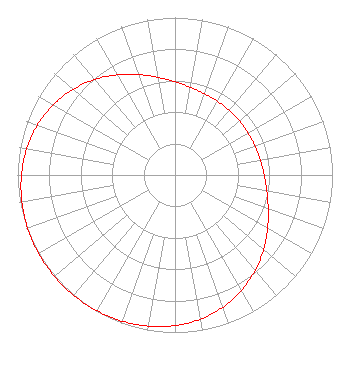 | ||||||||||||||||||
| Azimuth | Ratio | Azimuth | Ratio | Azimuth | Ratio | Azimuth | Ratio | ||||||||||||
| 0 | 0.592 | 10 | 0.566 | 20 | 0.549 | 30 | 0.540 | ||||||||||||
| 40 | 0.535 | 50 | 0.534 | 60 | 0.535 | 70 | 0.540 | ||||||||||||
| 80 | 0.549 | 90 | 0.566 | 100 | 0.592 | 110 | 0.630 | ||||||||||||
| 120 | 0.679 | 130 | 0.735 | 140 | 0.792 | 150 | 0.845 | ||||||||||||
| 160 | 0.892 | 170 | 0.929 | 180 | 0.956 | 190 | 0.975 | ||||||||||||
| 200 | 0.987 | 210 | 0.995 | 220 | 0.999 | 230 | 1.000 | ||||||||||||
| 240 | 0.999 | 250 | 0.995 | 260 | 0.987 | 270 | 0.975 | ||||||||||||
| 280 | 0.956 | 290 | 0.929 | 300 | 0.892 | 310 | 0.845 | ||||||||||||
| 320 | 0.792 | 330 | 0.735 | 340 | 0.679 | 350 | 0.630 | ||||||||||||
Structure Registration Number 1026748 Structure Type: LTOWER Registered To: SERVICE ELECTRIC CABLEVISION, INC. Structure Address: 1025 E. 9th Street Hazelton, PA County Name: Luzerne County ASR Issued: 08/05/2014 Date Built: 12/09/1987 Site Elevation: 575 m (1886 ft.) Structure Height: 33 m (108 ft.) Height Overall: 33 m (108 ft.) Overall Height AMSL: 608 m (1995 ft.) FAA Determination: 09/21/1987 FAA Study #: 87-AEA-1385-OE FAA Circular #: 70/7460-1G Paint & Light FAA Chapters: 3, 4, 5, 9 40-58-10.0 N 75-57-09.0 W (NAD 83) 40-58-09.7 N 75-57-10.3 W (Converted to NAD 27) |
P.o. Box 267 Dallas, PA 18612 Phone: 570-477-3688 | Date: 12/24/2008 Application Certifier GOSPEL MEDIA INSTITUTE, INC. 2457 Rt. 118 Hunlock Creek, PA 18621 Applicant BURL F. UPDYKE 2457 S.r. 118 Hunlock Creek, PA 18621-5022 PRESIDENT GOSPEL MEDIA INSTITUTE, INC. Gospel Media Institute, Inc. 2457 Rt. 118 Hunlock Creek, PA 18621 | |||||||||||||||||