
FCCInfo.com
A Service of Cavell, Mertz & Associates, Inc.
(855) FCC-INFO
|
|
KNWM from 07/21/1997 KNWM from 05/02/1997 |
|
|
||||||||||||||||
|
|
KNWM Channel: 241A 96.1 MHz Madrid, Iowa Service: FM - A full-service FM station or application. Facility ID: 42083 Fac. Service: FM Status: License 73.215 Station Application Accepted: 07/13/2015 Application Granted: 07/22/2015 File Number: BMLED-20150713ABO License Expires: 00/00/0000 Prefix Type: This is a modification of license for a noncommercial educational FM station Application Type: Minor Modification FCC Website Links: LMS Facility Details This Application CDBS Application Other KNWM Applications Other KNWM Applications in CDBS Including Superseded Applications Mailing Address Correspondence for KNWM Correspondence related to application BMLED-20150713ABO Service Contour - Open Street Map or USGS Map (60 dBu) Service Contour - KML / Google Earth (60 dBu) Public Inspection Files Facility Type: NON-COMMERCIAL EDUC. FM Class: A, A Zone I; I-A; or II station; with 0.1kW-6kW ERP and a class contour distance <=28km Site Location: 41-51-05.0 N 93-43-29.8 W (NAD 83) Site Location: 41-51-05.0 N 93-43-29.0 W (Converted to NAD 27) Effective Radiated Power: 6 kW Transmitter Output Power: 4 kW Antenna Center HAAT: 100 m (328 ft.) Antenna Center AMSL: 396 m (1299 ft.) Antenna Center HAG: 91 m (299 ft.) Calculated Site Elevation: 305 m. (1001 ft.) Height Overall*: 99.1 m (325 ft.) (* As Filed In This Application, may differ from ASR Data, Below.) Directional Antenna Antenna Make/Model: Electronics Research Inc. LP-4C-DA-HW Antenna ID: 89654 Polarization: | ||||||||||||||||||
| Antenna Data for Antenna Id: 89654 KNWM FM File: BMLED-20150713ABO Electronics Research Inc. - LP-4C-DA-HW Service: FM | 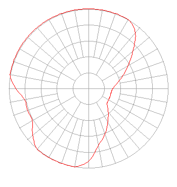 | ||||||||||||||||||
| Azimuth | Ratio | Azimuth | Ratio | Azimuth | Ratio | Azimuth | Ratio | ||||||||||||
| 0 | 1.000 | 10 | 1.000 | 20 | 1.000 | 30 | 1.000 | ||||||||||||
| 40 | 0.914 | 50 | 0.726 | 60 | 0.577 | 70 | 0.458 | ||||||||||||
| 80 | 0.364 | 90 | 0.306 | 100 | 0.289 | 110 | 0.289 | ||||||||||||
| 120 | 0.289 | 130 | 0.306 | 140 | 0.385 | 150 | 0.485 | ||||||||||||
| 160 | 0.611 | 170 | 0.726 | 180 | 0.914 | 190 | 1.000 | ||||||||||||
| 200 | 1.000 | 210 | 1.000 | 220 | 1.000 | 230 | 0.914 | ||||||||||||
| 240 | 0.815 | 250 | 0.815 | 260 | 0.815 | 270 | 0.914 | ||||||||||||
| 280 | 1.000 | 290 | 1.000 | 300 | 1.000 | 310 | 1.000 | ||||||||||||
| 320 | 1.000 | 330 | 1.000 | 340 | 1.000 | 350 | 1.000 | ||||||||||||
Structure Registration Number 1265420 Structure Type: TOWER Registered To: K2 Towers II, LLC Structure Address: 7701 Nw 158th Avenue Polk City, IA County Name: Polk County ASR Issued: 12/24/2019 Date Built: 12/06/2009 Site Elevation: 304.8 m (1000 ft.) Structure Height: 98.2 m (322 ft.) Height Overall: 99.1 m (325 ft.) Overall Height AMSL: 403.9 m (1325 ft.) FAA Determination: 02/29/2008 FAA Study #: 2008-ACE-335-OE FAA Circular #: 70/7460-1K Paint & Light FAA Chapters: 4, 8, 12 Removed expiration date from determination. Scenario 1./jjs/case#635066 41-51-05.0 N 93-43-29.8 W (NAD 83) 41-51-05.0 N 93-43-29.0 W (Converted to NAD 27) |
3003 Snelling Ave N Saint Paul, MN 55113-1501 Phone: 651-631-5000 | Date: 07/13/2015 Application Certifier UNIVERSITY OF NORTHWESTERN-ST. PAUL 3003 Snelling Avenue North Saint Paul, MN 55113-1598 Applicant JUSTIN W. ASHER Munn-reese, Inc. P.o. Box 220, 385 Airport Dr. Coldwater, MI 49036-0220 CONSULTING ENGINEER JOSEPH C. CHAUTIN, III Hardy, Carey, Chautin & Balkin, L.l.p. | |||||||||||||||||
|
| ||||||||||||||||||