
FCCInfo.com
A Service of Cavell, Mertz & Associates, Inc.
(855) FCC-INFO
|
|
WFCM-FM from 06/26/1995 |
|  |
|
|||||||||||||||
|
|
WFCM-FM Channel: 219C3 91.7 MHz Murfreesboro, Tennessee Service: FM - A full-service FM station or application. Facility ID: 66111 Fac. Service: FM Status: License Application Accepted: 04/11/2005 Application Granted: 03/06/2007 File Number: BLED-20050411AAI License Expires: 00/00/0000 Prefix Type: This is a license for a noncommercial educational FM station Application Type: Amendment FCC Website Links: LMS Facility Details This Application CDBS Application Other WFCM-FM Applications Other WFCM-FM Applications in CDBS Including Superseded Applications Mailing Address Correspondence for WFCM-FM Correspondence related to application BLED-20050411AAI Service Contour - Open Street Map or USGS Map (60 dBu) Service Contour - KML / Google Earth (60 dBu) Public Inspection Files Facility Type: NON-COMMERCIAL EDUC. FM Class: C3, A Zone II station; with 6kW-25kW ERP and a class contour distance 28km-39km Site Location: 35-48-01.2 N 86-37-17.0 W (NAD 83) Site Location: 35-48-01.0 N 86-37-17.0 W (Converted to NAD 27) Effective Radiated Power: 2.5 kW Horiz. ; 2.48 kW Vert. Transmitter Output Power: 4.16 kW Antenna Center HAAT: 231 m (758 ft.) Antenna Center AMSL: 468 m (1535 ft.) Antenna Center HAG: 152 m (499 ft.) Site Elevation: 316 m. (1037 ft.) Height Overall*: 229.3 m (752 ft.) (* As Filed In This Application, may differ from ASR Data, Below.) Directional Antenna Antenna Make/Model: Electronics Research Inc. 1093-1CP-DA Antenna ID: 60140 Polarization: | ||||||||||||||||||
| Antenna Data for Antenna Id: 60140 WFCM-FM FM File: BLED-20050411AAI Electronics Research Inc. - 1093-1CP-DA Service: FM | 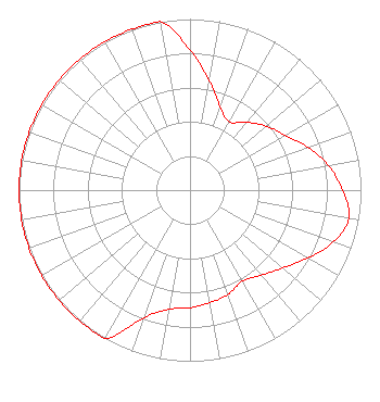 | ||||||||||||||||||
| Azimuth | Ratio | Azimuth | Ratio | Azimuth | Ratio | Azimuth | Ratio | ||||||||||||
| 0 | 0.818 | 10 | 0.649 | 20 | 0.516 | 30 | 0.460 | ||||||||||||
| 40 | 0.519 | 50 | 0.582 | 60 | 0.642 | 70 | 0.733 | ||||||||||||
| 80 | 0.822 | 90 | 0.891 | 100 | 0.944 | 110 | 0.891 | ||||||||||||
| 120 | 0.794 | 130 | 0.708 | 140 | 0.649 | 150 | 0.615 | ||||||||||||
| 160 | 0.649 | 170 | 0.668 | 180 | 0.688 | 190 | 0.708 | ||||||||||||
| 200 | 0.794 | 210 | 1.000 | 220 | 1.000 | 230 | 1.000 | ||||||||||||
| 240 | 1.000 | 250 | 1.000 | 260 | 1.000 | 270 | 1.000 | ||||||||||||
| 280 | 1.000 | 290 | 1.000 | 300 | 1.000 | 310 | 1.000 | ||||||||||||
| 320 | 1.000 | 330 | 1.000 | 340 | 1.000 | 350 | 1.000 | ||||||||||||
Structure Registration Number 1043245 Structure Type: GTOWER Registered To: GREAT COUNTRY TOWERS, INC. Structure Address: Atop Mccord Knob Kirkland, TN County Name: Williamson County ASR Issued: 08/11/2014 Date Built: 08/15/2014 Site Elevation: 316 m (1037 ft.) Structure Height: 228.9 m (751 ft.) Height Overall: 229.3 m (752 ft.) Overall Height AMSL: 545.3 m (1789 ft.) FAA Determination: 06/12/2014 FAA Study #: 2014-ASO-5039-OE FAA Circular #: 70/7460-1K Paint & Light FAA Chapters: 3, 4, 5, 12 PRIOR STUDY 1999-ASO-713-OE CHAPTERS 3,4,5,12 (1K) ADD SPECIAL CONDITION FOR LIGHTING DEVIATION. 35-48-01.0 N 86-37-17.0 W (NAD 83) 35-48-00.8 N 86-37-17.0 W (Converted to NAD 27) |
820 North Lasalle Boulevard Chicago, IL 60610-3214 Phone: 312-329-4438 Private Not-for-Profit Educational Institution | Date: 04/11/2005 Application Certifier THE MOODY BIBLE INSTITUTE OF CHICAGO 820 North Lasalle Boulevard Chicago, IL 60610-3284 Applicant JOHN J. MULLANEY Mullaney Engineering, Inc. 9049 Shady Grove Court Gaithersburg, MD 20877 CONSULTING ENGINEER JEFFREY D. SOUTHMAYD Southmayd & Miller | |||||||||||||||||