|
W270DL Channel: 270D 101.9 MHz
Milford, Connecticut
Service: FX - A translator or application for a translator.
Facility ID: 139339
FRN: 0003760436
Fac. Service: FX
Programming Delivery Method: Unspecified
Status: LIC
Application Accepted: 09/30/2019
Application Granted: 10/28/2019
File Number: 0000082854
License Expires: 04/01/2030
Application Type: License To Cover
FCC Website Links:
LMS Facility Details
This Application
Other W270DL Applications
Including Superseded Applications
Service Contour - Open Street Map or USGS Map (60 dBu)
Service Contour - KML / Google Earth (60 dBu)
Facility Type: FM STATION
Class: D, A Noncommercial educational operating with no more than 10W
Site Location: 41-20-59.3 N 72-58-21.4 W (NAD 83)
Site Location: 41-20-59.0 N 72-58-23.0 W (Converted to NAD 27)
Effective Radiated Power: 0.25 kW
Transmitter Output Power: 0.225 kW
Antenna Center AMSL: 201 m (659 ft.)
Antenna Center HAG: 67 m (220 ft.)
Site Elevation: 134 m. (440 ft.)
Height Overall*: 80 m (262 ft.)
(* As Filed In This Application, may differ from ASR Data, Below.)
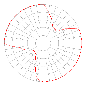
Directional Antenna
Antenna Make/Model: Scala CA-2-CP/FM ARRAY
Antenna ID: 133628
Polarization: H
| Primary Station |
| WFIF(AM) |
Ch. 0 | Milford, Connecticut |
|
Structure Information
Structure Registration Number 1045133
Structure Type: LTOWER
Registered To:
SBA Towers IX, LLC
Structure Address:
1055 Wintergreen Avenue (ct22107-a Tower #2)
Hamden, CT
County Name: New Haven County
ASR Issued: 12/10/2018
Date Built: 01/01/1979
Site Elevation: 134.1 m (440 ft.)
Structure Height: 76.2 m (250 ft.)
Height Overall: 79.9 m (262 ft.)
Overall Height AMSL: 214 m (702 ft.)
FAA Determination: 08/09/2017
FAA Study #: 2017-ANE-1825-OE
FAA Circular #: 70/7460-1L
Paint & Light FAA Chapters: 4, 8, 12
PRIOR STUDY 1997-ANE-492-OE
41-20-59.3 N 72-58-21.7 W (NAD 83)
41-20-59.0 N 72-58-23.3 W
(Converted to NAD 27)
|
W270DL(FX) Licensee Information
K. W. Dolmar Broadcasting Co. Inc.
8 Lawrence Road
Derry, NH 03038
Phone: 603-437-9337
Corporation | 0000082854 Applicant Information
William Blount
Title: President
Date: 09/30/2019
Application Certifier
K. W. Dolmar Broadcasting Co. Inc.
K. W. Dolmar Broadcasting Co. Inc.
8 Lawrence Road
Derry, NH 03038
Applicant
Joseph C Chautin, III
Hardy, Carey, Chautin & Balkin, LLP
1080 West Causeway Approach
Mandeville, LA 70471
Esq.
Scott Fybush
Fybush Consulting
92 Bonnie Brae Ave
Rochester, NY 14618
Technical Consultant
|