
FCCInfo.com
A Service of Cavell, Mertz & Associates, Inc.
(855) FCC-INFO
|
|
|
|  |
|
|||||||||||||||
|
|
KSWP Channel: 215C1 90.9 MHz Lufkin, Texas Service: FM - A full-service FM station or application. Facility ID: 39168 Fac. Service: FM Status: License Application Accepted: 10/24/2019 Application Granted: 01/13/2020 File Number: -0000087270 License Expires: 08/01/2021 Application Type: License To Cover FCC Website Links: LMS Facility Details This Application Other KSWP Applications Other KSWP Applications in CDBS Including Superseded Applications Mailing Address Correspondence for KSWP Correspondence related to application -0000087270 Service Contour - Open Street Map or USGS Map (60 dBu) Service Contour - KML / Google Earth (60 dBu) Public Inspection Files Facility Type: NON-COMMERCIAL EDUC. FM Class: C1, A Zone II station; with 50kW-100kW ERP and a class contour distance 52km-72km Site Location: 31-21-38.8 N 94-38-55.4 W (NAD 83) Site Location: 31-21-38.1 N 94-38-54.7 W (Converted to NAD 27) Effective Radiated Power: 100 kW Antenna Center HAAT: 271 m (889 ft.) Antenna Center AMSL: 353 m (1158 ft.) Antenna Center HAG: 274 m (899 ft.) Calculated Site Elevation: 79 m. (259 ft.) Height Overall*: 291 m (955 ft.) (* As Filed In This Application, may differ from ASR Data, Below.) Directional Antenna Antenna Make/Model: Electronics Research Inc. SHP-8AC-DA, 8 sections Antenna ID: 127492 Polarization: H | ||||||||||||||||||
| Antenna Data for Antenna Id: 127492 KSWP FM File: -0000087270 Electronics Research Inc. - SHP-8AC-DA, 8 sections Service: FM | 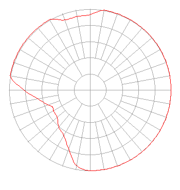 | ||||||||||||||||||
| Azimuth | Ratio | Azimuth | Ratio | Azimuth | Ratio | Azimuth | Ratio | ||||||||||||
| 0 | 0.930 | 10 | 1.000 | 20 | 1.000 | 30 | 1.000 | ||||||||||||
| 40 | 1.000 | 50 | 1.000 | 60 | 1.000 | 70 | 1.000 | ||||||||||||
| 80 | 1.000 | 90 | 1.000 | 100 | 1.000 | 110 | 1.000 | ||||||||||||
| 120 | 1.000 | 130 | 1.000 | 140 | 1.000 | 150 | 1.000 | ||||||||||||
| 160 | 1.000 | 170 | 1.000 | 180 | 1.000 | 190 | 0.950 | ||||||||||||
| 200 | 0.775 | 210 | 0.650 | 220 | 0.600 | 230 | 0.530 | ||||||||||||
| 240 | 0.520 | 245 | 0.510 | 250 | 0.550 | 260 | 0.650 | ||||||||||||
| 270 | 0.817 | 280 | 1.000 | 290 | 1.000 | 300 | 1.000 | ||||||||||||
| 310 | 1.000 | 320 | 1.000 | 330 | 1.000 | 340 | 0.920 | ||||||||||||
| 350 | 0.920 | ||||||||||||||||||
Structure Registration Number 1302151 [ASR Heights Differ from KSWP Application] Structure Type: GTOWER Registered To: LEBF, Inc. Structure Address: Golf Course Rd Lufkin, TX County Name: Angelina County ASR Issued: 05/04/2017 Date Built: 10/01/2019 Site Elevation: 79.2 m (260 ft.) Structure Height: 295.7 m (970 ft.) Height Overall: 298.7 m (980 ft.) Overall Height AMSL: 377.9 m (1240 ft.) FAA Determination: 10/05/2016 FAA Study #: 2016-ASW-7639-OE FAA Circular #: 70/7460-1L Paint & Light FAA Chapters: 4, 7, 12 31-21-38.8 N 94-38-55.4 W (NAD 83) 31-21-38.1 N 94-38-54.7 W (Converted to NAD 27) |
151 Holmes Rd Lufkin, TX 75904 Phone: 936-639-5673 Not-for-Profit | Title: President Date: 10/24/2019 Application Certifier LUFKIN EDUCATIONAL BROADCASTING FOUNDATION Lufkin Educational Broadcasting Foundation 151 Holmes Rd Lufkin, TX 75904 Applicant Tim Swanson Lufkin Educational Broadcasting Foundation 151 Holmes Road Lufkin, TX 75904 Representative BERT GOLDMAN Goldman Engineering Mgmt, Inc 560 Perkins Way Auburn, CA 95603 TECHNICAL CONSULTANT | |||||||||||||||||
|
| ||||||||||||||||||