
FCCInfo.com
A Service of Cavell, Mertz & Associates, Inc.
(855) FCC-INFO
|
|
|
|
|
||||||||||||||||
|
|
KWFN-FM4 Channel: 247D 97.3 MHz Escondido, California Service: FB - A booster station or application for a booster. Facility ID: 203664 Fac. Service: FB Programming Delivery Method: Unspecified Status: License Application Accepted: 12/12/2019 Application Granted: 03/23/2020 File Number: -0000093257 License Expires: 00/00/0000 Application Type: License To Cover FCC Website Links: LMS Facility Details This Application Other KWFN-FM4 Applications Other KWFN-FM4 Applications in CDBS Including Superseded Applications Mailing Address Correspondence for KWFN-FM4 Correspondence related to application -0000093257 Service Contour - Open Street Map or USGS Map (60 dBu) Service Contour - KML / Google Earth (60 dBu) Facility Type: FM STATION Class: D, A Noncommercial educational operating with no more than 10W Site Location: 32-58-52.2 N 117-06-57.8 W (NAD 83) Site Location: 32-58-52.0 N 117-06-54.7 W (Converted to NAD 27) Effective Radiated Power: 0.053 kW Horiz. ; 0.16 kW Vert. Antenna Center HAAT: 0 m Antenna Center AMSL: 472 m (1549 ft.) Antenna Center HAG: 16 m (52 ft.) Site Elevation: 456 m. (1496 ft.) Height Overall*: 34 m (112 ft.) (* As Filed In This Application, may differ from ASR Data, Below.) Directional Antenna Antenna Make/Model: None Antenna ID: 134796 Polarization:
| ||||||||||||||||||
| Antenna Data for Antenna Id: 134796 KWFN-FM4 FB File: -0000093257 None - Service: FB Pattern and Field Values Include a 351° Clockwise Rotation | 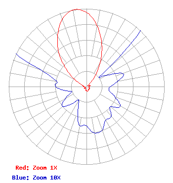 | ||||||||||||||||||
| Azimuth | Ratio | Azimuth | Ratio | Azimuth | Ratio | Azimuth | Ratio | ||||||||||||
| 1 | 0.940 | 11 | 0.770 | 21 | 0.550 | 31 | 0.330 | ||||||||||||
| 41 | 0.150 | 51 | 0.030 | 61 | 0.030 | 71 | 0.050 | ||||||||||||
| 81 | 0.040 | 91 | 0.030 | 101 | 0.030 | 111 | 0.040 | ||||||||||||
| 121 | 0.050 | 131 | 0.040 | 141 | 0.050 | 151 | 0.050 | ||||||||||||
| 161 | 0.060 | 171 | 0.060 | 181 | 0.050 | 191 | 0.050 | ||||||||||||
| 201 | 0.030 | 211 | 0.020 | 221 | 0.030 | 231 | 0.040 | ||||||||||||
| 241 | 0.030 | 251 | 0.020 | 261 | 0.030 | 271 | 0.040 | ||||||||||||
| 281 | 0.040 | 291 | 0.070 | 301 | 0.180 | 311 | 0.350 | ||||||||||||
| 321 | 0.570 | 331 | 0.760 | 341 | 0.930 | 351 | 1.000 | ||||||||||||
Structure Registration Number 1301779 [ASR Heights Differ from KWFN-FM4 Application] Structure Type: LTOWER Registered To: American Towers LLC Structure Address: 5.4m West Northwest Of Poway (89295) San Diego, CA County Name: San Diego County ASR Issued: 04/03/2024 Date Built: 08/01/1981 Site Elevation: 474.3 m (1556 ft.) Structure Height: 24.4 m (80 ft.) Height Overall: 33.8 m (111 ft.) Overall Height AMSL: 508.1 m (1667 ft.) FAA Determination: 04/02/2024 FAA Study #: 2024-AWP-2090-OE FAA Circular #: 70/7460-1K Paint & Light FAA Chapters: 4, 5, 12 OM&L to remain the same as prior study = RED LIGHTS 32-58-52.9 N 117-06-57.7 W (NAD 83) 32-58-52.7 N 117-06-54.6 W (Converted to NAD 27) |
2400 Market Street 4th Floor Philadelphia, PA 19103 Phone: 610-660-5610 Limited Liability Company | Title: Vice President Of Technical Operations Date: 12/12/2019 Application Certifier ENTERCOM LICENSE, LLC Entercom License, Llc 2400 Market Street 4th Floor Philadelphia, PA 19103 Applicant Laura M Berman Entercom Communications Corp. 2400 Market Street 4th Floor Philadelphia, PA 19103 Senior Counsel BERT GOLDMAN Goldman Engineering Mgmt. 560 Perkins Way Auburn, CA 95603 TECHNICAL CONSULTANT | |||||||||||||||||