
FCCInfo.com
A Service of Cavell, Mertz & Associates, Inc.
(855) FCC-INFO
|
|
W292HL from 03/09/2020 W292HL from 05/02/2018 W292HL from 04/16/2018 |
|
|
||||||||||||||||
|
|
W292HL Channel: 292D 106.3 MHz Troy, Alabama Service: FX - A translator or application for a translator. Facility ID: 201248 Fac. Service: FX Programming Delivery Method: Unspecified Status: License Application Accepted: 02/25/2020 Application Granted: 03/09/2020 File Number: -0000106564 License Expires: 08/01/2021 Application Type: License To Cover FCC Website Links: LMS Facility Details This Application Other W292HL Applications Other W292HL Applications in CDBS Including Superseded Applications Mailing Address Correspondence for W292HL Correspondence related to application -0000106564 Service Contour - Open Street Map or USGS Map (60 dBu) Service Contour - KML / Google Earth (60 dBu) Facility Type: FM STATION Class: D, A Noncommercial educational operating with no more than 10W Site Location: 31-48-32.0 N 85-59-50.0 W (NAD 83) Site Location: 31-48-31.4 N 85-59-50.2 W (Converted to NAD 27) Effective Radiated Power: 0.25 kW Antenna Center HAAT: 0 m Antenna Center AMSL: 304 m (997 ft.) Antenna Center HAG: 152 m (499 ft.) Site Elevation: 152 m. (499 ft.) Height Overall*: 158 m (518 ft.) (* As Filed In This Application, may differ from ASR Data, Below.) Directional Antenna Antenna Make/Model: Nicom BKG-77 Antenna ID: 133007 Polarization: H
| ||||||||||||||||||
| Antenna Data for Antenna Id: 133007 W292HL FX File: -0000106564 Nicom - BKG-77 Service: FX | 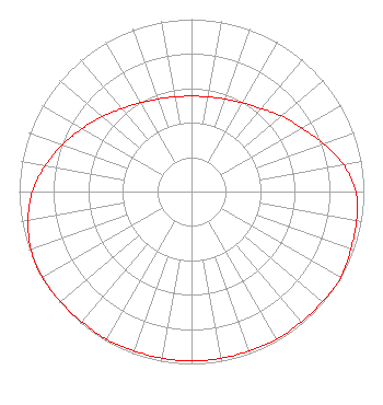 | ||||||||||||||||||
| Azimuth | Ratio | Azimuth | Ratio | Azimuth | Ratio | Azimuth | Ratio | ||||||||||||
| 0 | 0.553 | 10 | 0.558 | 20 | 0.571 | 30 | 0.594 | ||||||||||||
| 40 | 0.628 | 50 | 0.682 | 60 | 0.738 | 70 | 0.815 | ||||||||||||
| 80 | 0.897 | 90 | 0.953 | 100 | 0.973 | 110 | 0.983 | ||||||||||||
| 120 | 1.000 | 130 | 0.992 | 140 | 0.988 | 150 | 0.988 | ||||||||||||
| 160 | 0.983 | 170 | 0.983 | 180 | 0.983 | 190 | 0.983 | ||||||||||||
| 200 | 0.983 | 210 | 0.988 | 220 | 0.988 | 230 | 0.992 | ||||||||||||
| 240 | 1.000 | 250 | 0.991 | 260 | 0.963 | 270 | 0.923 | ||||||||||||
| 280 | 0.862 | 290 | 0.797 | 300 | 0.731 | 310 | 0.676 | ||||||||||||
| 320 | 0.628 | 330 | 0.594 | 340 | 0.571 | 350 | 0.558 | ||||||||||||
Structure Registration Number 1037684 Structure Type: TOWER Registered To: SANDERS TRUCK LINES LEAD COMPANY Structure Address: .6 Mi W Int 231 & Hwy 29 Troy, AL County Name: Pike County ASR Issued: 02/11/1998 Date Built: 11/01/1986 Site Elevation: 152 m (499 ft.) Structure Height: 152 m (499 ft.) Height Overall: 158 m (518 ft.) Overall Height AMSL: 310 m (1017 ft.) FAA Determination: 05/12/1986 FAA Study #: 85-ASO-2237-OE Paint & Light FAA Chapters: 1, 3, 4, 13, 21 RED LIGHTS/PAINT 31-48-32.0 N 85-59-50.0 W (NAD 83) 31-48-31.4 N 85-59-50.2 W (Converted to NAD 27) |
Post Office Box 369 Greenville, AL 36037 Phone: 334-549-3443 Limited Liability Company | Title: Managing Member Date: 02/25/2020 Application Certifier BRANTLEY BROADCAST ASSOCIATES LLC Brantley Broadcast Associates Llc P.o. Box 383174 Birmingham, AL 35238 Applicant Paul Reynolds Reynolds Technical Associates Birmingham, AL 35238 Technical Consultant | |||||||||||||||||