
FCCInfo.com
A Service of Cavell, Mertz & Associates, Inc.
(855) FCC-INFO
|
|
|
|
|
||||||||||||||||
|
|
W290DM Channel: 290D 105.9 MHz Midland, Michigan Service: FX - A translator or application for a translator. Facility ID: 202445 Fac. Service: FX Programming Delivery Method: Unspecified Status: License Application Accepted: 04/03/2020 Application Granted: 04/07/2020 File Number: -0000111400 License Expires: 10/01/2020 Application Type: License To Cover FCC Website Links: LMS Facility Details This Application Other W290DM Applications Other W290DM Applications in CDBS Including Superseded Applications Mailing Address Correspondence for W290DM Correspondence related to application -0000111400 Service Contour - Open Street Map or USGS Map (60 dBu) Service Contour - KML / Google Earth (60 dBu) Facility Type: FM STATION Class: D, A Noncommercial educational operating with no more than 10W Site Location: 43-37-44.7 N 84-10-10.0 W (NAD 83) Site Location: 43-37-44.6 N 84-10-10.0 W (Converted to NAD 27) Effective Radiated Power: 0.15 kW Antenna Center HAAT: 0 m Antenna Center AMSL: 274 m (899 ft.) Antenna Center HAG: 76 m (249 ft.) Site Elevation: 198 m. (650 ft.) Height Overall*: 107 m (351 ft.) (* As Filed In This Application, may differ from ASR Data, Below.) Directional Antenna Antenna Make/Model: Nicom BKG-77-1 Antenna ID: 132197 Polarization: H
| ||||||||||||||||||
| Antenna Data for Antenna Id: 132197 W290DM FX File: -0000111400 Nicom - BKG-77-1 Service: FX Pattern and Field Values Include a 310° Clockwise Rotation | 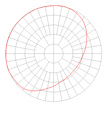 | ||||||||||||||||||
| Azimuth | Ratio | Azimuth | Ratio | Azimuth | Ratio | Azimuth | Ratio | ||||||||||||
| 0 | 0.992 | 10 | 1.000 | 20 | 0.991 | 30 | 0.963 | ||||||||||||
| 40 | 0.923 | 50 | 0.862 | 60 | 0.797 | 70 | 0.731 | ||||||||||||
| 80 | 0.676 | 90 | 0.628 | 100 | 0.594 | 110 | 0.571 | ||||||||||||
| 120 | 0.558 | 130 | 0.553 | 140 | 0.558 | 150 | 0.571 | ||||||||||||
| 160 | 0.594 | 170 | 0.628 | 180 | 0.682 | 190 | 0.738 | ||||||||||||
| 200 | 0.815 | 210 | 0.897 | 220 | 0.953 | 230 | 0.973 | ||||||||||||
| 240 | 0.983 | 250 | 1.000 | 260 | 0.992 | 270 | 0.988 | ||||||||||||
| 280 | 0.988 | 290 | 0.983 | 300 | 0.983 | 310 | 0.983 | ||||||||||||
| 320 | 0.983 | 330 | 0.983 | 340 | 0.988 | 350 | 0.988 | ||||||||||||
Structure Registration Number 1001018 Structure Type: GTOWER Registered To: American Towers, LLC Structure Address: 4625 Ashman Midland, MI County Name: Midland County ASR Issued: 02/07/2020 Date Built: 10/19/1994 Site Elevation: 197.8 m (649 ft.) Structure Height: 106.7 m (350 ft.) Height Overall: 106.7 m (350 ft.) Overall Height AMSL: 304.5 m (999 ft.) FAA Determination: 08/30/2012 FAA Study #: 2012-AGL-5801-OE FAA Circular #: 70/7460-1K Paint & Light FAA Chapters: 4, 8, 12 PRIOR STUDY 2003-AGL-6323-OE 43-37-44.6 N 84-10-09.8 W (NAD 83) 43-37-44.5 N 84-10-09.8 W (Converted to NAD 27) |
Post Office Box 373 Ann Arbor, MI 48106 Phone: 734-930-3210 Limited Liability Company | Title: Manager Date: 04/03/2020 Application Certifier AM MEDIA SERVICES, LLC Am Media Services, Llc Post Office Box 373 Ann Arbor, MI 48106 Applicant Dennis J. Kelly Law Office Of Dennis J. Kelly Post Office Box 41177 Washington, DC 20018-0577 Attorney Bruce Bellamy Munn-reese Post Office Box 220 Coldwater, MI 49036 ConsultingEngineer | |||||||||||||||||