
FCCInfo.com
A Service of Cavell, Mertz & Associates, Inc.
(855) FCC-INFO
|
|
|
|
|
||||||||||||||||
|
|
K274DF Channel: 274D 102.7 MHz Denver, Colorado Service: FX - A translator or application for a translator. Facility ID: 202881 Fac. Service: FX Programming Delivery Method: Unspecified Status: License Application Accepted: 05/06/2020 Application Granted: 05/08/2020 File Number: -0000113301 License Expires: 04/01/2021 Application Type: License To Cover FCC Website Links: LMS Facility Details This Application Other K274DF Applications Other K274DF Applications in CDBS Including Superseded Applications Mailing Address Correspondence for K274DF Correspondence related to application -0000113301 Service Contour - Open Street Map or USGS Map (60 dBu) Service Contour - KML / Google Earth (60 dBu) Facility Type: FM STATION Class: D, A Noncommercial educational operating with no more than 10W Site Location: 39-50-47.0 N 105-02-00.9 W (NAD 83) Site Location: 39-50-47.1 N 105-01-59.0 W (Converted to NAD 27) Effective Radiated Power: 0 kW Horiz. ; 0.25 kW Vert. Antenna Center HAAT: 0 m Antenna Center AMSL: 0 m Horiz.; 1771 m Vert. Antenna Center HAG: 0 m Horiz.; 81 m Vert. Site Elevation: 1690 m. (5545 ft.) Height Overall*: 84 m (276 ft.) (* As Filed In This Application, may differ from ASR Data, Below.) Directional Antenna Antenna Make/Model: Scala CA2-CP ARRAY Antenna ID: 135438 Polarization: H
| ||||||||||||||||||
| Antenna Data for Antenna Id: 135438 K274DF FX File: -0000113301 Scala - CA2-CP ARRAY Service: FX | 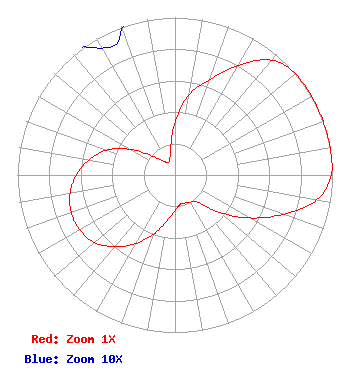 | ||||||||||||||||||
| Azimuth | Ratio | Azimuth | Ratio | Azimuth | Ratio | Azimuth | Ratio | ||||||||||||
| 0 | 0.336 | 10 | 0.518 | 20 | 0.645 | 30 | 0.804 | ||||||||||||
| 40 | 0.952 | 50 | 1.000 | 60 | 1.000 | 70 | 1.000 | ||||||||||||
| 80 | 1.000 | 90 | 0.993 | 100 | 0.914 | 110 | 0.730 | ||||||||||||
| 120 | 0.546 | 130 | 0.368 | 140 | 0.225 | 150 | 0.198 | ||||||||||||
| 160 | 0.189 | 170 | 0.188 | 180 | 0.225 | 190 | 0.298 | ||||||||||||
| 200 | 0.400 | 210 | 0.505 | 220 | 0.593 | 230 | 0.667 | ||||||||||||
| 240 | 0.698 | 250 | 0.701 | 260 | 0.676 | 270 | 0.625 | ||||||||||||
| 280 | 0.554 | 290 | 0.462 | 300 | 0.326 | 310 | 0.186 | ||||||||||||
| 320 | 0.116 | 330 | 0.093 | 340 | 0.099 | 350 | 0.163 | ||||||||||||
Structure Registration Number 1055826 Structure Type: TOWER Registered To: Pillar of Fire Structure Address: 8150 King St Westminster, CO County Name: Adams County ASR Issued: 11/27/2018 Date Built: 01/01/1977 Site Elevation: 1690.1 m (5545 ft.) Structure Height: 0.9 m (3 ft.) Height Overall: 84.4 m (277 ft.) Overall Height AMSL: 1774.5 m (5822 ft.) FAA Determination: 10/27/1998 FAA Study #: 98-ANM-0932-OE FAA Circular #: 70/7460-1J Paint & Light FAA Chapters: 3, 4, 5, 13 39-50-47.0 N 105-02-01.0 W (NAD 83) 39-50-47.1 N 105-01-59.1 W (Converted to NAD 27) |
3455 W. 83rd Ave. Westminster, CO 80031 Phone: 303-428-0910 Corporation | Title: Treasurer Date: 05/06/2020 Application Certifier PILLAR OF FIRE Pillar Of Fire 3455 W. 83rd Ave. Westminster, CO 80031 Applicant Jim Turvaville Turbo Tech Services 360 Patton Street - Po Box 144 Mobeetie, TX 79061 CONSULTING ENGINEER MATTHEW H. MCCORMICK Fletcher, Heald & Hildreth, Plc 1300 North 17th Street 11th Floor Arlington, VA 22209 | |||||||||||||||||