
FCCInfo.com
A Service of Cavell, Mertz & Associates, Inc.
(855) FCC-INFO
|
|
|
|
|
||||||||||||||||
|
|
K280GV Channel: 280D 103.9 MHz Atlanta, Texas Service: FX - A translator or application for a translator. Facility ID: 201324 Fac. Service: FX Programming Delivery Method: Unspecified Status: License (Licensed And Silent) Application Accepted: 07/13/2020 Application Granted: 07/24/2020 File Number: -0000117709 License Expires: 08/01/2021 Application Type: License To Cover FCC Website Links: LMS Facility Details This Application Other K280GV Applications Other K280GV Applications in CDBS Including Superseded Applications Mailing Address Correspondence for K280GV Correspondence related to application -0000117709 Service Contour - Open Street Map or USGS Map (60 dBu) Service Contour - KML / Google Earth (60 dBu) Facility Type: FM STATION Class: D, A Noncommercial educational operating with no more than 10W Site Location: 33-04-58.5 N 94-10-58.7 W (NAD 83) Site Location: 33-04-58.0 N 94-10-58.0 W (Converted to NAD 27) Effective Radiated Power: 0.25 kW Antenna Center HAAT: 0 m Antenna Center AMSL: 134 m (440 ft.) Antenna Center HAG: 63 m (207 ft.) Site Elevation: 71 m. (233 ft.) Height Overall*: 76 m (249 ft.) (* As Filed In This Application, may differ from ASR Data, Below.) Directional Antenna Antenna Make/Model: Nicom BKG77/1DA Antenna ID: 131895 Polarization:
| ||||||||||||||||||
| Antenna Data for Antenna Id: 131895 K280GV FX File: -0000117709 Nicom - BKG77/1DA Service: FX | 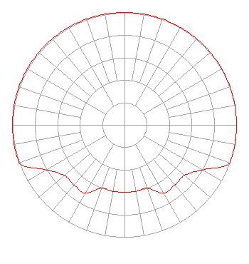 | ||||||||||||||||||
| Azimuth | Ratio | Azimuth | Ratio | Azimuth | Ratio | Azimuth | Ratio | ||||||||||||
| 0 | 1.000 | 10 | 1.000 | 20 | 1.000 | 30 | 1.000 | ||||||||||||
| 40 | 1.000 | 50 | 1.000 | 60 | 1.000 | 70 | 1.000 | ||||||||||||
| 80 | 1.000 | 90 | 1.000 | 100 | 1.000 | 110 | 1.000 | ||||||||||||
| 120 | 0.800 | 130 | 0.700 | 140 | 0.700 | 150 | 0.700 | ||||||||||||
| 160 | 0.600 | 170 | 0.600 | 180 | 0.600 | 190 | 0.600 | ||||||||||||
| 200 | 0.600 | 210 | 0.700 | 220 | 0.700 | 230 | 0.700 | ||||||||||||
| 240 | 0.800 | 250 | 1.000 | 260 | 1.000 | 270 | 1.000 | ||||||||||||
| 280 | 1.000 | 290 | 1.000 | 300 | 1.000 | 310 | 1.000 | ||||||||||||
| 320 | 1.000 | 330 | 1.000 | 340 | 1.000 | 350 | 1.000 | ||||||||||||
Structure Registration Number 1022028 Structure Type: TOWER Registered To: Ark-La-Tex BROADCASTING CO. Structure Address: 3.86 Km South Of Atlanta On Bivins Highway Atlanta, TX County Name: Cass County ASR Issued: 10/22/1999 Date Built: 01/01/1948 Site Elevation: 70.7 m (232 ft.) Structure Height: 75.6 m (248 ft.) Height Overall: 75.6 m (248 ft.) Overall Height AMSL: 146.3 m (480 ft.) FAA Determination: 05/07/1997 FAA Study #: 97-ASW-1072-OE FAA Circular #: 70/7460-1J Paint & Light FAA Chapters: 3, 4, 5, 13 33-04-58.4 N 94-10-58.6 W (NAD 83) 33-04-57.9 N 94-10-57.9 W (Converted to NAD 27) |
#715 Allen, TX 75013 Phone: 469-777-6560 Individual | Title: President Date: 07/13/2020 Application Certifier FREED AM CORPORATION Freed Am Corporation Po Box 900 Atlanta, TX 75551 Applicant GARY S. SMITHWICK, ESQ Smithwick & Belendiuk, P.c. 5028 Wisconsin Avenue, Nw Suite 301 Washington, DC 20016 Legal Counsel Justin Asher Asher Broadcast Consulting, Llc 579 Babcock Road Asher Broadcast Consulting, Llc Bronson, MI 49028-9347 Technical Consultant | |||||||||||||||||