
FCCInfo.com
A Service of Cavell, Mertz & Associates, Inc.
(855) FCC-INFO
|
|
KILV from 05/11/1998 |
|
|
||||||||||||||||
|
|
KILV Channel: 298C3 107.5 MHz Castana, Iowa Service: FM - A full-service FM station or application. Facility ID: 87226 Fac. Service: FM Status: License 73.215 Station Application Accepted: 07/17/2020 Application Granted: 10/05/2020 File Number: -0000118031 License Expires: 02/01/2021 Application Type: Minor Modification FCC Website Links: LMS Facility Details This Application Other KILV Applications Other KILV Applications in CDBS Including Superseded Applications Mailing Address Correspondence for KILV Correspondence related to application -0000118031 Service Contour - Open Street Map or USGS Map (60 dBu) Service Contour - KML / Google Earth (60 dBu) Public Inspection Files Facility Type: NON-COMMERCIAL EDUC. FM Class: C3, A Zone II station; with 6kW-25kW ERP and a class contour distance 28km-39km Site Location: 42-12-26.6 N 96-07-28.3 W (NAD 83) Site Location: 42-12-26.6 N 96-07-27.2 W (Converted to NAD 27) Effective Radiated Power: 25 kW Transmitter Output Power: 10.53 kW Antenna Center HAAT: 100 m (328 ft.) Antenna Center AMSL: 432 m (1417 ft.) Antenna Center HAG: 107 m (351 ft.) Site Elevation: 325 m. (1066 ft.) Height Overall*: 115 m (377 ft.) (* As Filed In This Application, may differ from ASR Data, Below.) Directional Antenna Antenna Make/Model: Electronics Research Inc. MP-6E-DA-HW Antenna ID: 39881 Polarization:
| ||||||||||||||||||
| Antenna Data for Antenna Id: 39881 KILV FM File: -0000118031 Electronics Research Inc. - MP-6E-DA-HW Service: FM | 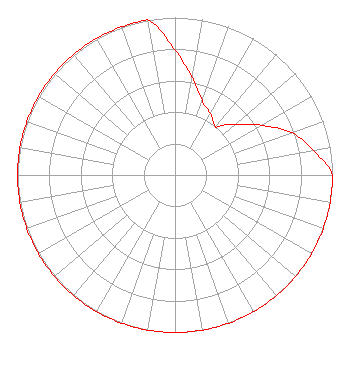 | ||||||||||||||||||
| Azimuth | Ratio | Azimuth | Ratio | Azimuth | Ratio | Azimuth | Ratio | ||||||||||||
| 0 | 0.793 | 10 | 0.631 | 20 | 0.502 | 30 | 0.450 | ||||||||||||
| 40 | 0.400 | 45 | 0.451 | 50 | 0.502 | 60 | 0.631 | ||||||||||||
| 70 | 0.787 | 80 | 0.893 | 90 | 1.000 | 100 | 1.000 | ||||||||||||
| 110 | 1.000 | 120 | 1.000 | 130 | 1.000 | 135 | 1.000 | ||||||||||||
| 140 | 1.000 | 150 | 1.000 | 160 | 1.000 | 170 | 1.000 | ||||||||||||
| 180 | 1.000 | 190 | 1.000 | 200 | 1.000 | 210 | 1.000 | ||||||||||||
| 220 | 1.000 | 225 | 1.000 | 230 | 1.000 | 240 | 1.000 | ||||||||||||
| 250 | 1.000 | 260 | 1.000 | 270 | 1.000 | 280 | 1.000 | ||||||||||||
| 290 | 1.000 | 300 | 1.000 | 310 | 1.000 | 315 | 1.000 | ||||||||||||
| 320 | 1.000 | 330 | 1.000 | 340 | 1.000 | 350 | 1.000 | ||||||||||||
Structure Registration Number 1204144 Structure Type: GTOWER Registered To: Educational Media Foundation Structure Address: 0.6 Miles Sw Of 340th Road, 2.1 Miles Sw Of Hornick Hornick, IA County Name: Monona County ASR Issued: 07/10/2020 Date Built: 07/10/2020 Site Elevation: 324.6 m (1065 ft.) Structure Height: 114.3 m (375 ft.) Height Overall: 115.2 m (378 ft.) Overall Height AMSL: 439.8 m (1443 ft.) FAA Determination: 07/08/2020 FAA Study #: 2020-ACE-4709-OE FAA Circular #: 70/7460-1J Paint & Light FAA Chapters: 3, 4, 5, 13 OM&L to remain the same as prior study = PAINT/RED LIGHTS 42-12-26.6 N 96-07-28.3 W (NAD 83) 42-12-26.6 N 96-07-27.2 W (Converted to NAD 27) |
5700 West Oaks Blvd Rocklin, CA 95765 Phone: 916-251-1600 Not-for-Profit | Title: Ceo Date: 07/17/2020 Application Certifier EDUCATIONAL MEDIA FOUNDATION Educational Media Foundation 5700 West Oaks Blvd Rocklin, CA 95765 Applicant JAMES L Travis Educational Media Foundation 5700 West Oaks Blvd. Rocklin, CA 95765 FCC COMPLIANCE ENGINEER Mary O'Connor, ESQ Wilkinson Barker Knauer, Llp 1800 M Street, N.w. Suite 800n Washington, DC 20036 Legal Representative | |||||||||||||||||