
FCCInfo.com
A Service of Cavell, Mertz & Associates, Inc.
(855) FCC-INFO
|
|
WYKC from 04/29/2008 WYKC from 10/30/2006 |
|  |
|
|||||||||||||||
|
|
WYKC Channel: 256A 99.1 MHz Whitefield, New Hampshire Service: FM - A full-service FM station or application. Facility ID: 165997 Fac. Service: FM Status: License 73.215 Station Application Accepted: 09/25/2020 Application Granted: 02/04/2021 File Number: -0000122436 License Expires: 04/01/2022 Application Type: Minor Modification FCC Website Links: LMS Facility Details This Application Other WYKC Applications Other WYKC Applications in CDBS Including Superseded Applications Mailing Address Correspondence for WYKC Correspondence related to application -0000122436 Service Contour - Open Street Map or USGS Map (60 dBu) Service Contour - KML / Google Earth (60 dBu) Public Inspection Files Facility Type: NON-COMMERCIAL EDUC. FM Class: A, A Zone I; I-A; or II station; with 0.1kW-6kW ERP and a class contour distance <=28km Site Location: 44-21-10.2 N 71-44-13.3 W (NAD 83) Site Location: 44-21-10.0 N 71-44-15.0 W (Converted to NAD 27) Effective Radiated Power: 0.45 kW Transmitter Output Power: 0.62 kW Antenna Center HAAT: 346 m (1135 ft.) Antenna Center AMSL: 701 m (2300 ft.) Antenna Center HAG: 85 m (279 ft.) Site Elevation: 615.7 m. (2020 ft.) Height Overall*: 136.2 m (447 ft.) (* As Filed In This Application, may differ from ASR Data, Below.) Directional Antenna Antenna Make/Model: Shivley 6810 Antenna ID: 122331 Polarization: | ||||||||||||||||||
| Antenna Data for Antenna Id: 122331 WYKC FM File: -0000122436 Shivley - 6810 Service: FM | 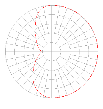 | ||||||||||||||||||
| Azimuth | Ratio | Azimuth | Ratio | Azimuth | Ratio | Azimuth | Ratio | ||||||||||||
| 0 | 1.000 | 10 | 1.000 | 20 | 1.000 | 30 | 1.000 | ||||||||||||
| 40 | 1.000 | 50 | 1.000 | 60 | 1.000 | 70 | 1.000 | ||||||||||||
| 80 | 1.000 | 90 | 1.000 | 100 | 1.000 | 110 | 1.000 | ||||||||||||
| 120 | 1.000 | 130 | 1.000 | 140 | 1.000 | 150 | 1.000 | ||||||||||||
| 160 | 1.000 | 170 | 1.000 | 180 | 1.000 | 190 | 0.966 | ||||||||||||
| 200 | 0.891 | 210 | 0.776 | 220 | 0.617 | 230 | 0.490 | ||||||||||||
| 240 | 0.389 | 250 | 0.309 | 260 | 0.245 | 270 | 0.222 | ||||||||||||
| 280 | 0.259 | 290 | 0.313 | 300 | 0.367 | 310 | 0.437 | ||||||||||||
| 320 | 0.550 | 330 | 0.692 | 340 | 0.871 | 350 | 0.966 | ||||||||||||
Structure Registration Number 1034698 [ASR Heights Differ from WYKC Application] Structure Type: GTOWER Registered To: New Hampshire Public Broadcasting Structure Address: Atop Mann Hill 3.8 Mi Ne Littleton, NH County Name: Grafton County ASR Issued: 04/08/2021 Date Built: 11/14/2016 Site Elevation: 606.2 m (1989 ft.) Structure Height: 121.9 m (400 ft.) Height Overall: 136.2 m (447 ft.) Overall Height AMSL: 742.4 m (2436 ft.) FAA Determination: 11/01/2016 FAA Study #: 2016-ANE-3277-OE FAA Circular #: 70/7460-1L Paint & Light FAA Chapters: 3, 4, 5, 12 Removed expiration date from determination. Scenario 1./jjs/case#635066 44-21-10.9 N 71-44-14.9 W (NAD 83) 44-21-10.7 N 71-44-16.6 W (Converted to NAD 27) |
5700 West Oaks Blvd Rocklin, CA 95765 Phone: 916-251-1600 Not-for-Profit | Title: Ceo Date: 09/25/2020 Application Certifier DEVON BROADCASTING COMPANY, INC. Educational Media Foundation 5700 West Oaks Blvd. Rocklin, CA 95765 Applicant Mary N O'Connor Wilkinson Barker Knauer, Llp 1800 K Street, Nw Suite 800n Washington, DC 20036 | |||||||||||||||||