
FCCInfo.com
A Service of Cavell, Mertz & Associates, Inc.
(855) FCC-INFO
|
|
|
|
|
||||||||||||||||
|
|
K284CT Channel: 283D 104.5 MHz Tyler, Texas Service: FX - A translator or application for a translator. Facility ID: 201161 Fac. Service: FX Programming Delivery Method: Unspecified Status: Construction Permit Application Accepted: 12/23/2020 Application Granted: 05/26/2021 File Number: -0000130082 K284CT CP Expires: 01/20/2024 Application Type: Minor Modification FCC Website Links: LMS Facility Details This Application Other K284CT Applications Other K284CT Applications in CDBS Including Superseded Applications Mailing Address Correspondence for K284CT Correspondence related to application -0000130082 Service Contour - Open Street Map or USGS Map (60 dBu) Service Contour - KML / Google Earth (60 dBu) Facility Type: FM STATION Class: D, A Noncommercial educational operating with no more than 10W Site Location: 32-14-23.6 N 95-15-07.8 W (NAD 83) Site Location: 32-14-23.0 N 95-15-07.0 W (Converted to NAD 27) Effective Radiated Power: 0.25 kW Antenna Center HAAT: 0 m Antenna Center AMSL: 262.7 m (862 ft.) Antenna Center HAG: 92 m (302 ft.) Site Elevation: 170.7 m. (560 ft.) Height Overall*: 98.5 m (323 ft.) (* As Filed In This Application, may differ from ASR Data, Below.) Directional Antenna Antenna Make/Model: NICOM BKG77 Antenna ID: 129795 Polarization: H
| ||||||||||||||||||
| Antenna Data for Antenna Id: 129795 K284CT FX File: -0000130082 NICOM - BKG77 Service: FX | 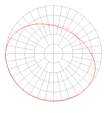 | ||||||||||||||||||
| Azimuth | Ratio | Azimuth | Ratio | Azimuth | Ratio | Azimuth | Ratio | ||||||||||||
| 0 | 0.583 | 10 | 0.565 | 20 | 0.556 | 30 | 0.556 | ||||||||||||
| 40 | 0.565 | 50 | 0.583 | 60 | 0.611 | 70 | 0.656 | ||||||||||||
| 80 | 0.710 | 90 | 0.777 | 100 | 0.856 | 110 | 0.925 | ||||||||||||
| 120 | 0.963 | 130 | 0.978 | 140 | 0.992 | 145 | 1.000 | ||||||||||||
| 150 | 0.996 | 160 | 0.990 | 170 | 0.988 | 180 | 0.986 | ||||||||||||
| 190 | 0.982 | 200 | 0.982 | 210 | 0.983 | 220 | 0.983 | ||||||||||||
| 230 | 0.986 | 240 | 0.988 | 250 | 0.990 | 260 | 0.996 | ||||||||||||
| 265 | 1.000 | 270 | 0.996 | 280 | 0.977 | 290 | 0.943 | ||||||||||||
| 300 | 0.893 | 310 | 0.830 | 320 | 0.764 | 330 | 0.704 | ||||||||||||
| 340 | 0.652 | 350 | 0.611 | ||||||||||||||||
Structure Registration Number 1060013 Structure Type: TOWER Registered To: CCATT LLC Structure Address: Rhomes Quarter Road Whitehouse, TX County Name: Smith County ASR Issued: 05/09/2016 Date Built: 01/25/1999 Site Elevation: 170.7 m (560 ft.) Structure Height: 97.5 m (320 ft.) Height Overall: 98.5 m (323 ft.) Overall Height AMSL: 269.2 m (883 ft.) FAA Determination: 08/30/2006 FAA Study #: 2006-ASW-5979-OE FAA Circular #: 70/7460-1J Paint & Light FAA Chapters: 4, 8, 13 OM&L to remain the same as prior study = A MED-DUAL SYSTEM 32-14-23.6 N 95-15-07.8 W (NAD 83) 32-14-23.0 N 95-15-07.0 W (Converted to NAD 27) |
5946 Club Oaks Drive Dallas, TX 75248 Phone: 972-931-6055 Limited Partnership | Title: Managing Member Date: 12/23/2020 Application Certifier EAST TEXAS RESULTS MEDIA, LLC East Texas Results Media, Llc Thornton, AR 71776 Applicant Donald Lynch Horizon Broadcast Solutions, Llc 111 Sam Houston Dr. Kerrville, TX 78028 TECHNICAL CONSULTANT STEPHEN LOVELADY Fletcher, Heald & Hildreth, P.l.c. 1300 North 17th Street Suite 1100 Arlington, VA 22209 | |||||||||||||||||