
FCCInfo.com
A Service of Cavell, Mertz & Associates, Inc.
(855) FCC-INFO
|
|
|
|
|
||||||||||||||||
|
|
W224EE Channel: 224D 92.7 MHz Charleston, West Virginia Service: FX - A translator or application for a translator. Facility ID: 202928 Fac. Service: FX Programming Delivery Method: Unspecified Status: License Application Accepted: 05/10/2021 Application Granted: 06/14/2021 File Number: -0000144995 License Expires: 10/01/2027 Application Type: License To Cover FCC Website Links: LMS Facility Details This Application Other W224EE Applications Other W224EE Applications in CDBS Including Superseded Applications Mailing Address Correspondence for W224EE Correspondence related to application -0000144995 Service Contour - Open Street Map or USGS Map (60 dBu) Service Contour - KML / Google Earth (60 dBu) Facility Type: FM STATION Class: D, A Noncommercial educational operating with no more than 10W Site Location: 38-21-26.3 N 81-40-04.5 W (NAD 83) Site Location: 38-21-26.0 N 81-40-05.1 W (Converted to NAD 27) Effective Radiated Power: 0.25 kW Antenna Center HAAT: 0 m Antenna Center AMSL: 314 m (1030 ft.) Antenna Center HAG: 22 m (72 ft.) Site Elevation: 292 m. (958 ft.) Height Overall*: 105 m (344 ft.) (* As Filed In This Application, may differ from ASR Data, Below.) Directional Antenna Antenna Make/Model: Jampro JLLP Antenna ID: 132576 Polarization: H
| ||||||||||||||||||
| Antenna Data for Antenna Id: 132576 W224EE FX File: -0000144995 Jampro - JLLP Service: FX | 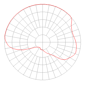 | ||||||||||||||||||
| Azimuth | Ratio | Azimuth | Ratio | Azimuth | Ratio | Azimuth | Ratio | ||||||||||||
| 0 | 1.000 | 10 | 1.000 | 20 | 1.000 | 30 | 1.000 | ||||||||||||
| 40 | 1.000 | 50 | 0.984 | 60 | 0.870 | 70 | 0.823 | ||||||||||||
| 80 | 0.831 | 90 | 0.871 | 100 | 0.898 | 110 | 0.904 | ||||||||||||
| 120 | 0.823 | 130 | 0.718 | 140 | 0.477 | 150 | 0.365 | ||||||||||||
| 160 | 0.304 | 170 | 0.245 | 180 | 0.207 | 190 | 0.203 | ||||||||||||
| 200 | 0.170 | 210 | 0.163 | 220 | 0.174 | 230 | 0.210 | ||||||||||||
| 240 | 0.316 | 250 | 0.598 | 260 | 0.837 | 270 | 0.951 | ||||||||||||
| 280 | 1.000 | 290 | 1.000 | 300 | 1.000 | 310 | 1.000 | ||||||||||||
| 320 | 1.000 | 330 | 1.000 | 340 | 1.000 | 350 | 1.000 | ||||||||||||
Structure Registration Number 1033439 [ASR Heights Differ from W224EE Application] Structure Type: TOWER Registered To: BRISTOL BROADCASTING COMPANY INC Structure Address: 817 Suncrest Pl Charleston, WV County Name: Kanawha County ASR Issued: 01/14/2013 Date Built: 01/01/1984 Site Elevation: 292.6 m (960 ft.) Structure Height: 84.1 m (276 ft.) Height Overall: 105.5 m (346 ft.) Overall Height AMSL: 398.1 m (1306 ft.) FAA Determination: 06/18/1984 FAA Study #: 84-AEA-1045-OE Paint & Light FAA Chapters: 1, 3, 12, 21 RED LIGHTS/PAINT 38-21-26.0 N 81-40-04.0 W (NAD 83) 38-21-25.7 N 81-40-04.6 W (Converted to NAD 27) |
901 East Valley Drive Bristol, VA 24201 Phone: 276-669-8112 Corporation | Title: Corporate General Manager/director Date: 05/10/2021 Application Certifier BRISTOL BROADCASTING COMPANY, INC. Bristol Broadcasting Company, Inc. 901 East Valley Drive Bristol, VA 24201 Applicant ROGER D BOULDIN Bristol Broadcasting Company, Inc. 901 East Valley Drive Bristol, VA 24201 DIRECTOR/ENGINEER ROGER Bouldin Bristol Broadcasting Company, Inc. 901 East Valley Drive Bristol, VA 24201 Corporate General Manager/Director | |||||||||||||||||