
FCCInfo.com
A Service of Cavell, Mertz & Associates, Inc.
(855) FCC-INFO
|
|
KWAO from 09/09/2003 |
|
|
||||||||||||||||
|
|
KWAO Channel: 201C 88.1 MHz Vashon, Washington Service: FS - A full service FM station auxiliary transmitting antenna or application. Facility ID: 121867 Fac. Service: FM Status: Construction Permit Application Accepted: 06/01/2021 Application Granted: 07/19/2021 File Number: -0000149204 KWAO CP Expires: 07/19/2024 Application Type: Construction Permit FCC Website Links: LMS Facility Details This Application Other KWAO Applications Other KWAO Applications in CDBS Including Superseded Applications Mailing Address Correspondence for KWAO Correspondence related to application -0000149204 Service Contour - Open Street Map or USGS Map (60 dBu) Service Contour - KML / Google Earth (60 dBu) Public Inspection Files Facility Type: NON-COMMERCIAL EDUC. FM Class: C, A Zone II station; with exactly 100kW ERP and a class contour distance 72km-92km Site Location: 46-58-30.6 N 123-08-21.0 W (NAD 83) Site Location: 46-58-31.3 N 123-08-16.5 W (Converted to NAD 27) Effective Radiated Power: 0 kW Horiz. ; 4.6 kW Vert. Antenna Center HAAT: 0 m Horiz.; 697 m Vert. Antenna Center AMSL: 0 m Horiz.; 896.8 m Vert. Antenna Center HAG: 0 m Horiz.; 90 m Vert. Site Elevation: 806.8 m. (2647 ft.) Height Overall*: 93 m (305 ft.) (* As Filed In This Application, may differ from ASR Data, Below.) Directional Antenna Antenna Make/Model: None Antenna ID: 69-2019-08-06 Polarization: | ||||||||||||||||||
| Antenna Data for Antenna Id: 69-2019-08-06 KWAO FS File: -0000149204 None - Service: FS | 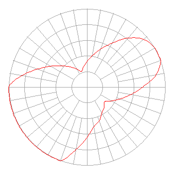 | ||||||||||||||||||
| Azimuth | Ratio | Azimuth | Ratio | Azimuth | Ratio | Azimuth | Ratio | ||||||||||||
| 0 | 0.325 | 10 | 0.409 | 20 | 0.515 | 30 | 0.648 | ||||||||||||
| 40 | 0.816 | 50 | 0.947 | 60 | 1.000 | 70 | 1.000 | ||||||||||||
| 80 | 0.896 | 90 | 0.712 | 100 | 0.566 | 110 | 0.449 | ||||||||||||
| 120 | 0.357 | 130 | 0.293 | 140 | 0.339 | 150 | 0.381 | ||||||||||||
| 160 | 0.460 | 170 | 0.512 | 180 | 0.645 | 190 | 0.811 | ||||||||||||
| 200 | 1.000 | 210 | 1.000 | 220 | 1.000 | 230 | 1.000 | ||||||||||||
| 240 | 1.000 | 250 | 1.000 | 260 | 1.000 | 270 | 1.000 | ||||||||||||
| 280 | 0.842 | 290 | 0.669 | 300 | 0.531 | 310 | 0.422 | ||||||||||||
| 320 | 0.335 | 330 | 0.266 | 340 | 0.212 | 350 | 0.260 | ||||||||||||
Structure Registration Number 1231674 Structure Type: TOWER Registered To: Weyerhaeuser NR Company Structure Address: Top Of Capitol Peak Littlerock, WA County Name: Thurston County ASR Issued: 10/25/2023 Date Built: 06/04/2002 Site Elevation: 806.8 m (2647 ft.) Structure Height: 91.4 m (300 ft.) Height Overall: 93 m (305 ft.) Overall Height AMSL: 899.8 m (2952 ft.) FAA Determination: 01/04/2002 FAA Study #: 98-ANM-0765-OE FAA Circular #: 70/7460-1J Paint & Light FAA Chapters: 3, 4, 5, 13 Removed expiration date from determination. Scenario 1./jjs/case#635066 46-58-30.6 N 123-08-21.0 W (NAD 83) 46-58-31.3 N 123-08-16.5 W (Converted to NAD 27) |
5700 West Oaks Blvd. Rocklin, CA 95765 Phone: 916-251-1600 Not-for-Profit | Title: Ceo Date: 06/01/2021 Application Certifier EDUCATIONAL MEDIA FOUNDATION Educational Media Foundation 5700 West Oaks Blvd. Rocklin, CA 95765 Applicant MARY N O'CONNOR Wilkinson Barker Knauer, Llp 1800 M. Street, N.w. Suite 800n Washington, DC 20036 LINDA ADAMS Educational Media Foundation 5700 West Oaks Blvd. Rocklin, CA 95765 | |||||||||||||||||
| |||||||||||||||||||