
FCCInfo.com
A Service of Cavell, Mertz & Associates, Inc.
(855) FCC-INFO
|
|
|
|
|
||||||||||||||||
|
|
WGGY-FM3 Channel: 267D 101.3 MHz Hazleton, Pennsylvania Service: FB - A booster station or application for a booster. Facility ID: 203403 Fac. Service: FB Programming Delivery Method: Unspecified Status: License Application Accepted: 06/10/2021 Application Granted: 06/25/2021 File Number: -0000149954 License Expires: 08/01/2030 Application Type: License To Cover FCC Website Links: LMS Facility Details This Application Other WGGY-FM3 Applications Other WGGY-FM3 Applications in CDBS Including Superseded Applications Mailing Address Correspondence for WGGY-FM3 Correspondence related to application -0000149954 Service Contour - Open Street Map or USGS Map (60 dBu) Service Contour - KML / Google Earth (60 dBu) Facility Type: FM STATION Class: D, A Noncommercial educational operating with no more than 10W Site Location: 40-58-08.9 N 75-57-27.1 W (NAD 83) Site Location: 40-58-08.6 N 75-57-28.4 W (Converted to NAD 27) Effective Radiated Power: 0.014 kW Antenna Center HAAT: 0 m Antenna Center AMSL: 619 m (2031 ft.) Antenna Center HAG: 49 m (161 ft.) Site Elevation: 570 m. (1870 ft.) Height Overall*: 61 m (200 ft.) (* As Filed In This Application, may differ from ASR Data, Below.) Directional Antenna Antenna Make/Model: None Antenna ID: 132812 Polarization:
| ||||||||||||||||||
| Antenna Data for Antenna Id: 132812 WGGY-FM3 FB File: -0000149954 None - Service: FB Pattern and Field Values Include a 20° Clockwise Rotation | 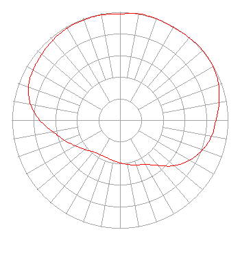 | ||||||||||||||||||
| Azimuth | Ratio | Azimuth | Ratio | Azimuth | Ratio | Azimuth | Ratio | ||||||||||||
| 0 | 0.982 | 10 | 0.999 | 20 | 0.995 | 30 | 0.990 | ||||||||||||
| 40 | 0.996 | 50 | 1.000 | 60 | 0.994 | 70 | 0.971 | ||||||||||||
| 80 | 0.932 | 90 | 0.889 | 100 | 0.860 | 110 | 0.811 | ||||||||||||
| 120 | 0.744 | 130 | 0.656 | 140 | 0.547 | 150 | 0.472 | ||||||||||||
| 160 | 0.443 | 170 | 0.415 | 180 | 0.395 | 190 | 0.378 | ||||||||||||
| 200 | 0.368 | 210 | 0.369 | 220 | 0.384 | 230 | 0.423 | ||||||||||||
| 240 | 0.475 | 250 | 0.545 | 260 | 0.628 | 270 | 0.745 | ||||||||||||
| 280 | 0.840 | 290 | 0.902 | 300 | 0.929 | 310 | 0.945 | ||||||||||||
| 320 | 0.966 | 330 | 0.981 | 340 | 0.986 | 350 | 0.988 | ||||||||||||
Structure Registration Number 1232866 Structure Type: TOWER Registered To: Jordan Realty Structure Address: Pardee Street Hazleton, PA County Name: Luzerne County ASR Issued: 03/13/2002 Date Built: 03/21/2003 Site Elevation: 569.9 m (1870 ft.) Structure Height: 54.8 m (180 ft.) Height Overall: 60.7 m (199 ft.) Overall Height AMSL: 630.6 m (2069 ft.) FAA Determination: 02/20/2002 FAA Study #: 01-AEA-4442-OE Paint & Light FAA Chapters: A1, H, 3, 11, 21, 23 OM&L TO REMAIN MED DUAL SYSTEM AS PER PRIOR STUDY 01-AEA-2686-OE 40-58-08.9 N 75-57-27.1 W (NAD 83) 40-58-08.6 N 75-57-28.4 W (Converted to NAD 27) |
2400 Market Street 4th Floor Philadelphia, PA 19103 Phone: 610-660-5610 Limited Liability Company | Title: Svp Of Technical Operations Date: 06/10/2021 Application Certifier ENTERCOM LICENSE, LLC Audacy License, Llc 2400 Market Street 4th Floor Philadelphia, PA 19103 Applicant LAURA M. BERMAN Audacy, Inc. 2400 Market Street, 4th Floor Philadelphia, PA 19103 ERIK C SWANSON, PE Hatfield & Dawson Hatfield & Dawson Consulting Engineers 9500 Greenwood Ave N Seattle, WA 98103 CONSULTING ENGINEER | |||||||||||||||||
| |||||||||||||||||||