
FCCInfo.com
A Service of Cavell, Mertz & Associates, Inc.
(855) FCC-INFO
|
|
|
|
|
||||||||||||||||
|
|
K254DN Channel: 254D 98.7 MHz Eugene, Oregon Service: FX - A translator or application for a translator. Facility ID: 202478 Fac. Service: FX Programming Delivery Method: Unspecified Status: License Application Accepted: 08/09/2021 Application Granted: 09/07/2021 File Number: -0000156714 License Expires: 02/01/2022 Application Type: License To Cover FCC Website Links: LMS Facility Details This Application Other K254DN Applications Other K254DN Applications in CDBS Including Superseded Applications Mailing Address Correspondence for K254DN Correspondence related to application -0000156714 Service Contour - Open Street Map or USGS Map (60 dBu) Service Contour - KML / Google Earth (60 dBu) Facility Type: FM STATION Class: D, A Noncommercial educational operating with no more than 10W Site Location: 44-00-05.5 N 123-06-55.9 W (NAD 83) Site Location: 44-00-06.1 N 123-06-51.6 W (Converted to NAD 27) Effective Radiated Power: 0.099 kW Antenna Center HAAT: 0 m Antenna Center AMSL: 424 m (1391 ft.) Antenna Center HAG: 28 m (92 ft.) Site Elevation: 396 m. (1299 ft.) Height Overall*: 90 m (295 ft.) (* As Filed In This Application, may differ from ASR Data, Below.) Directional Antenna Antenna Make/Model: Kathrein CA2-FM/CV Antenna ID: 132848 Polarization: H
| ||||||||||||||||||
| Antenna Data for Antenna Id: 132848 K254DN FX File: -0000156714 Kathrein - CA2-FM/CV Service: FX | 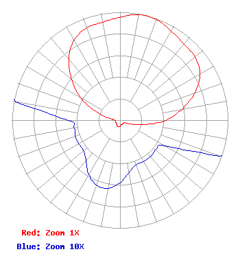 | ||||||||||||||||||
| Azimuth | Ratio | Azimuth | Ratio | Azimuth | Ratio | Azimuth | Ratio | ||||||||||||
| 0 | 0.951 | 10 | 0.991 | 20 | 0.991 | 30 | 0.951 | ||||||||||||
| 40 | 0.920 | 50 | 0.907 | 60 | 0.853 | 70 | 0.738 | ||||||||||||
| 80 | 0.582 | 90 | 0.427 | 100 | 0.236 | 110 | 0.098 | ||||||||||||
| 120 | 0.048 | 130 | 0.043 | 140 | 0.044 | 150 | 0.044 | ||||||||||||
| 160 | 0.044 | 170 | 0.049 | 180 | 0.058 | 190 | 0.064 | ||||||||||||
| 200 | 0.064 | 210 | 0.058 | 220 | 0.049 | 230 | 0.044 | ||||||||||||
| 240 | 0.044 | 250 | 0.044 | 260 | 0.043 | 270 | 0.048 | ||||||||||||
| 280 | 0.098 | 290 | 0.236 | 300 | 0.427 | 310 | 0.582 | ||||||||||||
| 320 | 0.738 | 330 | 0.853 | 340 | 0.907 | 350 | 0.920 | ||||||||||||
Structure Registration Number 1205503 Structure Type: GTOWER Registered To: EIP Holdings II, LLC Structure Address: 4545 Blanton Road Eugene, OR County Name: Lane County ASR Issued: 11/30/2023 Date Built: 03/18/2016 Site Elevation: 396.3 m (1300 ft.) Structure Height: 88.4 m (290 ft.) Height Overall: 89.9 m (295 ft.) Overall Height AMSL: 486.2 m (1595 ft.) FAA Determination: 03/03/2016 FAA Study #: 2015-ANM-2319-OE Paint & Light FAA Chapters: NONE PRIOR STUDY 2008-ANM-3205-OE 44-00-06.0 N 123-06-51.6 W (NAD 83) 44-00-06.6 N 123-06-47.3 W (Converted to NAD 27) |
200 North Monroe Street Eugene, OR 97402 Phone: 541-790-7707 Private Not-for-Profit Educational Institution | Title: Board Chair Date: 08/09/2021 Application Certifier LANE COUNTY SCHOOL DISTRICT NO. 4J Lane County School District No. 4j 200 North Monroe Street Eugene, OR 97402 Applicant Tom Woods Woods Communications, Inc. Creswell, OR 97426 CONSULTANT JESSICA A Rogers Luvaas Cobb 777 High Street Suite 300 Eugene, OR 97401 Attorney | |||||||||||||||||