
FCCInfo.com
A Service of Cavell, Mertz & Associates, Inc.
(855) FCC-INFO
|
|
KKLP from 02/06/2015 KKLP from 03/28/2011 |
|
|
||||||||||||||||
|
|
KKLP Channel: 216B1 91.1 MHz Perris, California Service: FM - A full-service FM station or application. Facility ID: 175839 Fac. Service: FM Status: License Application Accepted: 09/09/2021 Application Granted: 09/15/2021 File Number: -0000158964 License Expires: 12/01/2021 Application Type: Minor Modification FCC Website Links: LMS Facility Details This Application Other KKLP Applications Other KKLP Applications in CDBS Including Superseded Applications Mailing Address Correspondence for KKLP Correspondence related to application -0000158964 Service Contour - Open Street Map or USGS Map (60 dBu) Service Contour - KML / Google Earth (60 dBu) Public Inspection Files Facility Type: NON-COMMERCIAL EDUC. FM Class: B1, A Zone I or I-A station; with 6kW-25kW ERP and a class contour distance 28km-39km Site Location: 33-49-49.1 N 116-57-14.1 W (NAD 83) Site Location: 33-49-49.0 N 116-57-11.0 W (Converted to NAD 27) Effective Radiated Power: 0.285 kW Antenna Center HAAT: 464 m (1522 ft.) Antenna Center AMSL: 1161 m (3809 ft.) Antenna Center HAG: 21 m (69 ft.) Site Elevation: 1140 m. (3740 ft.) Height Overall*: 39 m (128 ft.) (* As Filed In This Application, may differ from ASR Data, Below.) Directional Antenna Antenna Make/Model: Shively 6025/1/DA/Slant,1 section Antenna ID: 134336 Polarization: H
| ||||||||||||||||||
| Antenna Data for Antenna Id: 134336 KKLP FM File: -0000158964 Shively - 6025/1/DA/Slant,1 section Service: FM | 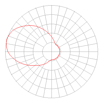 | ||||||||||||||||||
| Azimuth | Ratio | Azimuth | Ratio | Azimuth | Ratio | Azimuth | Ratio | ||||||||||||
| 0 | 0.321 | 10 | 0.256 | 20 | 0.204 | 30 | 0.179 | ||||||||||||
| 40 | 0.178 | 50 | 0.178 | 60 | 0.178 | 70 | 0.178 | ||||||||||||
| 80 | 0.178 | 90 | 0.178 | 100 | 0.178 | 110 | 0.178 | ||||||||||||
| 120 | 0.178 | 130 | 0.178 | 140 | 0.178 | 150 | 0.178 | ||||||||||||
| 160 | 0.178 | 170 | 0.178 | 180 | 0.178 | 190 | 0.199 | ||||||||||||
| 200 | 0.249 | 210 | 0.314 | 220 | 0.385 | 230 | 0.470 | ||||||||||||
| 240 | 0.585 | 250 | 0.715 | 260 | 0.840 | 270 | 0.940 | ||||||||||||
| 280 | 0.990 | 285 | 1.000 | 290 | 0.986 | 300 | 0.936 | ||||||||||||
| 310 | 0.838 | 320 | 0.731 | 330 | 0.626 | 340 | 0.508 | ||||||||||||
| 350 | 0.404 | ||||||||||||||||||
Structure Registration Number 1202397 Structure Type: LTOWER Registered To: American Towers LLC Structure Address: 40700 Soboba Road (8672) Banning, CA County Name: Riverside County ASR Issued: 02/04/2015 Date Built: 12/17/1998 Site Elevation: 1139.9 m (3740 ft.) Structure Height: 36.6 m (120 ft.) Height Overall: 39 m (128 ft.) Overall Height AMSL: 1178.9 m (3868 ft.) FAA Determination: 01/09/2015 FAA Study #: 2014-AWP-9445-OE Paint & Light FAA Chapters: NONE Removed expiration date from determination. Scenario 1./jjs/case#635066 33-49-49.2 N 116-57-14.1 W (NAD 83) 33-49-49.1 N 116-57-11.0 W (Converted to NAD 27) |
5700 West Oaks Boulevard Rocklin, CA 95765 Phone: 916-251-1600 Not-for-Profit | Title: Ceo Date: 09/09/2021 Application Certifier EDUCATIONAL MEDIA FOUNDATION Educational Media Foundation 5700 West Oaks Boulevard Rocklin, CA 95765 Applicant MARY O'CONNOR Wilkinson Barker Knauer, Llp 1800 M Street, N. W. Suite 800n Washington, DC 20036 Legal Representative James L Travis Educational Media Foundation 5700 West Oaks Blvd. Rocklin, CA 95765 FCC COMPLIANCE ENGINEER | |||||||||||||||||