
FCCInfo.com
A Service of Cavell, Mertz & Associates, Inc.
(855) FCC-INFO
|
|
W285FB from 10/31/2013 |
|
|
||||||||||||||||
|
|
W285FB Channel: 285D 104.9 MHz Brentwood, Tennessee Service: FX - A translator or application for a translator. Facility ID: 156000 Fac. Service: FX Programming Delivery Method: Unspecified Status: License Application Accepted: 10/04/2021 Application Granted: 10/15/2021 File Number: -0000162534 License Expires: 08/01/2028 Application Type: License To Cover FCC Website Links: LMS Facility Details This Application Other W285FB Applications Other W285FB Applications in CDBS Including Superseded Applications Mailing Address Correspondence for W285FB Correspondence related to application -0000162534 Service Contour - Open Street Map or USGS Map (60 dBu) Service Contour - KML / Google Earth (60 dBu) Facility Type: NON-COMMERCIAL EDUC. FM Class: D, A Noncommercial educational operating with no more than 10W Site Location: 36-02-59.0 N 86-49-59.0 W (NAD 83) Site Location: 36-02-58.8 N 86-49-59.0 W (Converted to NAD 27) Effective Radiated Power: 0 kW Horiz. ; 0.25 kW Vert. Transmitter Output Power: 0.129 kW Antenna Center HAAT: 0 m Antenna Center AMSL: 0 m Horiz.; 404.1 m Vert. Antenna Center HAG: 0 m Horiz.; 78 m Vert. Site Elevation: 326.1 m. (1070 ft.) Height Overall*: 95.1 m (312 ft.) (* As Filed In This Application, may differ from ASR Data, Below.) Directional Antenna Antenna Make/Model: SCALA CL-FM-V Antenna ID: 16124 Polarization: H
| ||||||||||||||||||
| Antenna Data for Antenna Id: 16124 W285FB FX File: -0000162534 SCALA - CL-FM-V Service: FX | 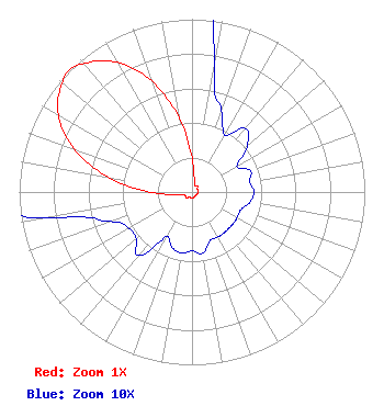 | ||||||||||||||||||
| Azimuth | Ratio | Azimuth | Ratio | Azimuth | Ratio | Azimuth | Ratio | ||||||||||||
| 0 | 0.198 | 10 | 0.074 | 20 | 0.050 | 30 | 0.038 | ||||||||||||
| 40 | 0.048 | 50 | 0.042 | 60 | 0.030 | 70 | 0.036 | ||||||||||||
| 80 | 0.034 | 90 | 0.036 | 100 | 0.034 | 110 | 0.030 | ||||||||||||
| 120 | 0.030 | 130 | 0.030 | 140 | 0.030 | 150 | 0.030 | ||||||||||||
| 160 | 0.030 | 170 | 0.036 | 180 | 0.034 | 190 | 0.036 | ||||||||||||
| 200 | 0.034 | 210 | 0.030 | 220 | 0.048 | 230 | 0.042 | ||||||||||||
| 240 | 0.042 | 250 | 0.050 | 260 | 0.086 | 270 | 0.242 | ||||||||||||
| 280 | 0.492 | 290 | 0.726 | 300 | 0.894 | 310 | 0.980 | ||||||||||||
| 315 | 1.000 | 320 | 0.970 | 330 | 0.866 | 340 | 0.684 | ||||||||||||
| 350 | 0.438 | ||||||||||||||||||
Structure Registration Number 1043960 Structure Type: GTOWER Registered To: Pinnacle Towers LLC Structure Address: .5 Mi. N Of Old Hickory Blvd. Wnge Hill Brentwood, TN County Name: Davidson County ASR Issued: 05/06/2016 Date Built: 01/01/1974 Site Elevation: 326.1 m (1070 ft.) Structure Height: 91.7 m (301 ft.) Height Overall: 95.1 m (312 ft.) Overall Height AMSL: 421.2 m (1382 ft.) FAA Determination: 10/29/2012 FAA Study #: 2012-ASO-10119-OE FAA Circular #: 70/7460-1K Paint & Light FAA Chapters: 4, 6, 12 PRIOR STUDY 2009-ASO-6635-OE 36-02-59.0 N 86-49-59.0 W (NAD 83) 36-02-58.8 N 86-49-59.0 W (Converted to NAD 27) |
2631b Nolensville Pike Nashville, TN 37211 Phone: 615-844-1039 Not-for-Profit | Title: President Date: 10/04/2021 Application Certifier Nashville's Sportsradio, Incorporated 2631b Nolensville Pike Nashville, TN 37211 Applicant Randolph Bell Nashville's Sportradio, Incorporated 2631b Nolensville Pike Nashville, TN 37211 Jim Turvaville Turbo Tech Services 360 Patton Street - Po Box 144 Mobeetie, TX 79061 | |||||||||||||||||