
FCCInfo.com
A Service of Cavell, Mertz & Associates, Inc.
(855) FCC-INFO
|
|
|
|  |
|
|||||||||||||||
|
|
KVCF Channel: 213C1 90.5 MHz Freeman, South Dakota Service: FM - A full-service FM station or application. Facility ID: 92640 Fac. Service: FM Status: Construction Permit Application Accepted: 10/04/2021 Application Granted: 03/04/2022 File Number: -0000162811 KVCF CP Expires: 03/04/2025 Application Type: Minor Modification FCC Website Links: LMS Facility Details This Application Other KVCF Applications Other KVCF Applications in CDBS Including Superseded Applications Mailing Address Correspondence for KVCF Correspondence related to application -0000162811 Service Contour - Open Street Map or USGS Map (60 dBu) Service Contour - KML / Google Earth (60 dBu) Public Inspection Files Facility Type: NON-COMMERCIAL EDUC. FM Class: C1, A Zone II station; with 50kW-100kW ERP and a class contour distance 52km-72km Site Location: 43-43-46.0 N 97-05-14.9 W (NAD 83) Site Location: 43-43-46.1 N 97-05-13.7 W (Converted to NAD 27) Effective Radiated Power: 20 kW Antenna Center HAAT: 250 m (820 ft.) Antenna Center AMSL: 749 m (2457 ft.) Antenna Center HAG: 200 m (656 ft.) Site Elevation: 548.6 m. (1800 ft.) Height Overall*: 268.5 m (881 ft.) (* As Filed In This Application, may differ from ASR Data, Below.) Directional Antenna Antenna Make/Model: None Antenna ID: 1006063 Polarization:
| ||||||||||||||||||
| Antenna Data for Antenna Id: 1006063 KVCF FM File: -0000162811 None - Service: FM | 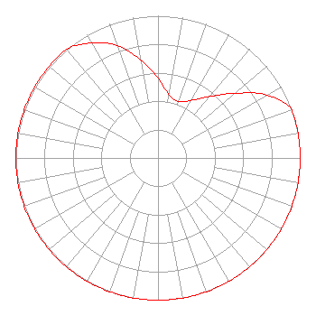 | ||||||||||||||||||
| Azimuth | Ratio | Azimuth | Ratio | Azimuth | Ratio | Azimuth | Ratio | ||||||||||||
| 0 | 0.559 | 10 | 0.449 | 20 | 0.422 | 30 | 0.468 | ||||||||||||
| 40 | 0.564 | 50 | 0.709 | 60 | 0.885 | 70 | 1.000 | ||||||||||||
| 80 | 1.000 | 90 | 1.000 | 100 | 1.000 | 110 | 1.000 | ||||||||||||
| 120 | 1.000 | 130 | 1.000 | 140 | 1.000 | 150 | 1.000 | ||||||||||||
| 160 | 1.000 | 170 | 1.000 | 180 | 1.000 | 190 | 1.000 | ||||||||||||
| 200 | 1.000 | 210 | 1.000 | 220 | 1.000 | 230 | 1.000 | ||||||||||||
| 240 | 1.000 | 250 | 1.000 | 260 | 1.000 | 270 | 1.000 | ||||||||||||
| 280 | 1.000 | 290 | 1.000 | 300 | 1.000 | 310 | 1.000 | ||||||||||||
| 320 | 1.000 | 330 | 0.933 | 340 | 0.841 | 350 | 0.699 | ||||||||||||
Structure Registration Number 1221133 Structure Type: TOWER Registered To: Townsquare Media Sioux Falls, LLC Structure Address: West Of Hwy. 19, 5.7 Miles North Of Humboldt, SD County Name: Minnehaha County ASR Issued: 12/09/2021 Date Built: 04/10/2000 Site Elevation: 548.6 m (1800 ft.) Structure Height: 267.6 m (878 ft.) Height Overall: 268.5 m (881 ft.) Overall Height AMSL: 817.1 m (2681 ft.) FAA Determination: 11/14/2000 FAA Study #: 00-AGL-2232-OE Paint & Light FAA Chapters: 1, 3, 6, 15, 21 Removed embedded carriage return(s) and extraneous quotation marks./jjs/case#1764417 43-43-46.0 N 97-05-14.9 W (NAD 83) 43-43-46.1 N 97-05-13.7 W (Converted to NAD 27) |
3434 W Kilbourn Ave Milwaukee, WI 53208 Phone: 414-935-3000 Not-for-Profit | Title: Vice President Of Communications Date: 10/04/2021 Application Certifier Vcy America, Inc. 3434 W Kilbourn Ave Milwaukee, WI 53208 Applicant Robert Branch Ctm 440 Astillero Street Las Vegas, NV 89138 Technical Consultant Kathryne Dickerson Wiley Rein Llp 1776 K Street Nw Washington, DC 20006 | |||||||||||||||||