
FCCInfo.com
A Service of Cavell, Mertz & Associates, Inc.
(855) FCC-INFO
|
|
WMWA from 08/09/1991 |
|
|
||||||||||||||||
|
|
WMWA Channel: 243C3 96.5 MHz Malone, New York Service: FM - A full-service FM station or application. Facility ID: 36121 Fac. Service: FM Status: License (Licensed And Silent) 73.215 Station Application Accepted: 10/20/2021 Application Granted: 10/21/2021 File Number: -0000157511 License Expires: 06/01/2022 Application Type: Minor Amendment FCC Website Links: LMS Facility Details This Application Other WMWA Applications Other WMWA Applications in CDBS Including Superseded Applications Mailing Address Correspondence for WMWA Correspondence related to application -0000157511 Service Contour - Open Street Map or USGS Map (60 dBu) Service Contour - KML / Google Earth (60 dBu) Public Inspection Files Facility Type: NON-COMMERCIAL EDUC. FM Class: C3, A Zone II station; with 6kW-25kW ERP and a class contour distance 28km-39km Site Location: 44-46-56.0 N 74-13-08.0 W (NAD 83) Site Location: 44-46-55.8 N 74-13-09.4 W (Converted to NAD 27) Effective Radiated Power: 23.5 kW Transmitter Output Power: 4.6 kW Antenna Center HAAT: 105 m (344 ft.) Antenna Center AMSL: 519 m (1703 ft.) Antenna Center HAG: 61 m (200 ft.) Site Elevation: 458.1 m. (1503 ft.) Height Overall*: 92.1 m (302 ft.) (* As Filed In This Application, may differ from ASR Data, Below.) Directional Antenna Antenna Make/Model: Systems With Reliability Inc. FM3d/4-DA,4 sections Antenna ID: 68161 Polarization: H | ||||||||||||||||||
| Antenna Data for Antenna Id: 68161 WMWA FM File: -0000157511 Systems With Reliability Inc. - FM3d/4-DA,4 sections Service: FM | 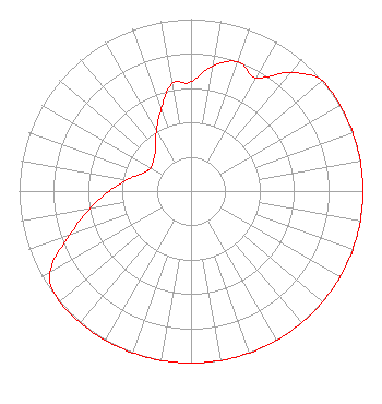 | ||||||||||||||||||
| Azimuth | Ratio | Azimuth | Ratio | Azimuth | Ratio | Azimuth | Ratio | ||||||||||||
| 0 | 0.635 | 10 | 0.740 | 20 | 0.800 | 30 | 0.760 | ||||||||||||
| 40 | 0.900 | 50 | 1.000 | 60 | 1.000 | 70 | 1.000 | ||||||||||||
| 80 | 1.000 | 90 | 1.000 | 100 | 1.000 | 110 | 1.000 | ||||||||||||
| 120 | 1.000 | 130 | 1.000 | 140 | 1.000 | 150 | 1.000 | ||||||||||||
| 160 | 1.000 | 170 | 1.000 | 180 | 1.000 | 190 | 1.000 | ||||||||||||
| 200 | 1.000 | 210 | 1.000 | 220 | 1.000 | 230 | 1.000 | ||||||||||||
| 240 | 0.949 | 250 | 0.754 | 260 | 0.599 | 270 | 0.475 | ||||||||||||
| 280 | 0.378 | 290 | 0.300 | 300 | 0.270 | 310 | 0.285 | ||||||||||||
| 320 | 0.320 | 330 | 0.403 | 340 | 0.507 | 350 | 0.633 | ||||||||||||
Structure Registration Number 1064217 [ASR Heights Differ from WMWA Application] Structure Type: GTOWER Registered To: Educational Media Foundation Structure Address: Off Teboville Road Malone, NY County Name: Franklin County ASR Issued: 12/14/2023 Date Built: 05/05/1999 Site Elevation: 460.2 m (1510 ft.) Structure Height: 74.4 m (244 ft.) Height Overall: 74.4 m (244 ft.) Overall Height AMSL: 534.6 m (1754 ft.) FAA Determination: 09/28/2023 FAA Study #: 2022-AEA-12807-OE FAA Circular #: 70/7460-1M Paint & Light FAA Chapters: 3, 4, 5, 15 44-46-53.8 N 74-13-06.8 W (NAD 83) 44-46-53.6 N 74-13-08.2 W (Converted to NAD 27) |
5700 West Oaks Blvd. Rocklin, CA 95765 Phone: 916-251-1600 Not-for-Profit | Title: Ceo Date: 10/20/2021 Application Certifier MARTZ COMMUNICATIONS GROUP INC. Educational Media Foundation 5700 West Oaks Blvd. Rocklin, CA 95765 Applicant Mary O'Connor Wilkinson Barker Knauer, Llp 1800 M Street, Nw Suite 800n Washington, DC 20036 | |||||||||||||||||