
FCCInfo.com
A Service of Cavell, Mertz & Associates, Inc.
(855) FCC-INFO
|
|
|
|  |
|
|||||||||||||||
|
|
WCNY-FM Channel: 217B 91.3 MHz Syracuse, New York Service: FM - A full-service FM station or application. Facility ID: 66284 Fac. Service: FM Analog & Digital Status: License Application Accepted: 10/28/2021 Application Granted: 11/08/2021 File Number: -0000165133 License Expires: 06/01/2022 Application Type: Amendment FCC Website Links: LMS Facility Details This Application Other WCNY-FM Applications Other WCNY-FM Applications in CDBS Including Superseded Applications Mailing Address Correspondence for WCNY-FM Correspondence related to application -0000165133 Service Contour - Open Street Map or USGS Map (60 dBu) Service Contour - KML / Google Earth (60 dBu) Public Inspection Files History Cards for WCNY-FM Facility Type: NON-COMMERCIAL EDUC. FM Class: B, A Zone I or I-A station; with 25kW-50kW ERP and a class contour distance 39km-52km Site Location: 42-56-41.8 N 76-07-06.2 W (NAD 83) Site Location: 42-56-41.6 N 76-07-07.5 W (Converted to NAD 27) Effective Radiated Power: 8.3 kW Antenna Center HAAT: 334 m (1096 ft.) Antenna Center AMSL: 630 m (2067 ft.) Antenna Center HAG: 198 m (650 ft.) Site Elevation: 431.9 m. (1417 ft.) Height Overall*: 284.1 m (932 ft.) (* As Filed In This Application, may differ from ASR Data, Below.) Directional Antenna Antenna Make/Model: Propagation System, Inc. PSIFMCB-3-DA Antenna ID: 1008876 Polarization: | ||||||||||||||||||
| Antenna Data for Antenna Id: 1008876 WCNY-FM FM File: -0000165133 Propagation System, Inc. - PSIFMCB-3-DA Service: FM | 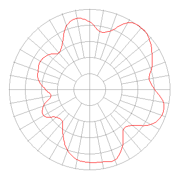 | ||||||||||||||||||
| Azimuth | Ratio | Azimuth | Ratio | Azimuth | Ratio | Azimuth | Ratio | ||||||||||||
| 0 | 0.842 | 10 | 0.733 | 20 | 0.774 | 30 | 0.955 | ||||||||||||
| 37 | 1.000 | 40 | 0.995 | 43 | 1.000 | 50 | 0.969 | ||||||||||||
| 60 | 0.896 | 70 | 0.826 | 80 | 0.752 | 90 | 0.807 | ||||||||||||
| 100 | 0.932 | 110 | 0.953 | 120 | 0.876 | 130 | 0.697 | ||||||||||||
| 140 | 0.654 | 150 | 0.816 | 160 | 0.931 | 170 | 0.916 | ||||||||||||
| 180 | 0.908 | 190 | 0.886 | 200 | 0.803 | 210 | 0.658 | ||||||||||||
| 220 | 0.523 | 230 | 0.538 | 240 | 0.656 | 250 | 0.608 | ||||||||||||
| 260 | 0.484 | 270 | 0.548 | 280 | 0.643 | 290 | 0.679 | ||||||||||||
| 300 | 0.700 | 310 | 0.667 | 320 | 0.593 | 330 | 0.668 | ||||||||||||
| 340 | 0.840 | 350 | 0.895 | ||||||||||||||||
Structure Registration Number 1233154 Structure Type: TOWER Registered To: WSTQ Licensee, LLC Structure Address: 3623 Sentinel Heights Road Lafayette, NY County Name: Onondaga County ASR Issued: 01/12/2017 Date Built: 09/05/2003 Site Elevation: 431.9 m (1417 ft.) Structure Height: 245.3 m (805 ft.) Height Overall: 284.1 m (932 ft.) Overall Height AMSL: 716 m (2349 ft.) FAA Determination: 05/30/2002 FAA Study #: 01-AEA-3454-OE FAA Circular #: 70/7460-1K Paint & Light FAA Chapters: 4, 9, 12 42-56-41.8 N 76-07-06.2 W (NAD 83) 42-56-41.6 N 76-07-07.5 W (Converted to NAD 27) |
415 W. Fayette St. Syracuse, NY 13204 Phone: 315-453-2424 Not-for-Profit | Title: Senior Director, Engineering Date: 10/28/2021 Application Certifier PUBLIC BROADCASTING COUNCIL OF CENTRAL NEW YORK Public Broadcasting Council Of Central New York P.o. Box 2400 Syracuse, NY 13220 Applicant Derek Teslik Gray Miller Persh Llp 2233 Wisconsin Avenue Nw Ste. 226 Washington, DC 20007 Ryan C Wilhour Kessler And Gehman Associates, Inc. 507 Nw 60th St Ste D Gainesville, FL 32607 Consulting Engineer | |||||||||||||||||
| |||||||||||||||||||