
FCCInfo.com
A Service of Cavell, Mertz & Associates, Inc.
(855) FCC-INFO
|
|
|
|
|
||||||||||||||||
|
|
KSOA Channel: 213B1 90.5 MHz Soledad, California Service: FM - A full-service FM station or application. Facility ID: 767193 Fac. Service: FM Status: Construction Permit Application Accepted: 11/09/2021 Application Granted: 01/13/2022 File Number: -0000167437 KSOA CP Expires: 01/13/2025 Application Type: Non-Commercial Educational New NCE FM CP FCC Website Links: LMS Facility Details This Application Other KSOA Applications Other KSOA Applications in CDBS Including Superseded Applications Mailing Address Correspondence for KSOA Correspondence related to application -0000167437 Service Contour - Open Street Map or USGS Map (60 dBu) Service Contour - KML / Google Earth (60 dBu) Public Inspection Files Facility Type: NON-COMMERCIAL EDUC. FM Class: B1, A Zone I or I-A station; with 6kW-25kW ERP and a class contour distance 28km-39km Site Location: 36-36-44.6 N 121-03-53.2 W (NAD 83) Site Location: 36-36-44.7 N 121-03-49.5 W (Converted to NAD 27) Effective Radiated Power: 0.25 kW Antenna Center HAAT: 523.11 m (1716 ft.) Antenna Center AMSL: 1193.7 m (3916 ft.) Antenna Center HAG: 12 m (39 ft.) Site Elevation: 1181.7 m. (3877 ft.) Height Overall*: 17.7 m (58 ft.) (* As Filed In This Application, may differ from ASR Data, Below.) Directional Antenna Antenna Make/Model: None Antenna ID: 69-2019-08-06 Polarization: | ||||||||||||||||||
| Antenna Data for Antenna Id: 69-2019-08-06 KSOA FM File: -0000167437 None - Service: FM | 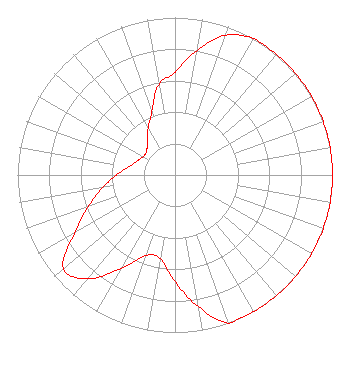 | ||||||||||||||||||
| Azimuth | Ratio | Azimuth | Ratio | Azimuth | Ratio | Azimuth | Ratio | ||||||||||||
| 0 | 0.653 | 10 | 0.805 | 20 | 0.944 | 30 | 1.000 | ||||||||||||
| 40 | 1.000 | 50 | 1.000 | 60 | 1.000 | 70 | 1.000 | ||||||||||||
| 80 | 1.000 | 90 | 1.000 | 100 | 1.000 | 110 | 1.000 | ||||||||||||
| 120 | 1.000 | 130 | 1.000 | 140 | 1.000 | 150 | 1.000 | ||||||||||||
| 160 | 1.000 | 170 | 0.849 | 180 | 0.676 | 190 | 0.539 | ||||||||||||
| 200 | 0.546 | 210 | 0.685 | 220 | 0.860 | 230 | 0.925 | ||||||||||||
| 240 | 0.737 | 250 | 0.587 | 260 | 0.468 | 270 | 0.373 | ||||||||||||
| 280 | 0.297 | 290 | 0.258 | 300 | 0.233 | 310 | 0.236 | ||||||||||||
| 320 | 0.272 | 330 | 0.341 | 340 | 0.428 | 350 | 0.585 | ||||||||||||
Structure Registration Number 1015986 Structure Type: TOWER Registered To: American Towers LLC Structure Address: 2 Mi. S Of Panoche Rd. From Hwy 25 (call Mountain #8202) Paicines, CA County Name: San Benito County ASR Issued: 01/15/2013 Date Built: 01/01/1961 Site Elevation: 1181.7 m (3877 ft.) Structure Height: 14 m (46 ft.) Height Overall: 17.7 m (58 ft.) Overall Height AMSL: 1199.4 m (3935 ft.) FAA Determination: 08/23/2006 FAA Study #: 2006-AWP-4964-OE Paint & Light FAA Chapters: NONE Removed expiration date from determination. Scenario 1./jjs/case#635066 36-36-44.6 N 121-03-53.2 W (NAD 83) 36-36-44.7 N 121-03-49.5 W (Converted to NAD 27) |
4002 N. 3300 E. Twin Falls, ID 83303 Phone: 208-733-3133 Not-for-Profit | Title: President Date: 11/09/2021 Application Certifier CALVARY CHAPEL OF TWIN FALLS, INC. Calvary Chapel Pearl Harbor 94-1044 Waipio Uka St Waipahu, HI 96797 Applicant SCOTT SPENCER Calvary Chapel Pearl Harbor 223 Bob Barton Jerome, ID 83338 TECHNICAL REPRESENTATIVE Derald Skinner Calvary Chapel Pearl Harbor 94-1044 Waipio Uka St Waipahu, HI 96797 | |||||||||||||||||