
FCCInfo.com
A Service of Cavell, Mertz & Associates, Inc.
(855) FCC-INFO
|
|
|
|
|
||||||||||||||||
|
|
K277DS Channel: 277D 103.3 MHz Billings, Montana Service: FX - A translator or application for a translator. Facility ID: 202296 Fac. Service: FX Programming Delivery Method: Unspecified Status: License Application Accepted: 11/03/2021 Application Granted: 12/08/2021 File Number: -0000165975 License Expires: 04/01/2029 Application Type: License To Cover FCC Website Links: LMS Facility Details This Application Other K277DS Applications Other K277DS Applications in CDBS Including Superseded Applications Mailing Address Correspondence for K277DS Correspondence related to application -0000165975 Service Contour - Open Street Map or USGS Map (60 dBu) Service Contour - KML / Google Earth (60 dBu) Facility Type: FM STATION Class: D, A Noncommercial educational operating with no more than 10W Site Location: 45-45-59.0 N 108-27-21.0 W (NAD 83) Site Location: 45-45-59.2 N 108-27-18.5 W (Converted to NAD 27) Effective Radiated Power: 0.099 kW Antenna Center HAAT: 0 m Antenna Center AMSL: 1155.9 m (3792 ft.) Antenna Center HAG: 51 m (167 ft.) Site Elevation: 1104.9 m. (3625 ft.) Height Overall*: 112.8 m (370 ft.) (* As Filed In This Application, may differ from ASR Data, Below.) Directional Antenna Antenna Make/Model: Kathrein-Scala CA2-FM/CP Antenna ID: 133950 Polarization: H
| ||||||||||||||||||
| Antenna Data for Antenna Id: 133950 K277DS FX File: -0000165975 Kathrein-Scala - CA2-FM/CP Service: FX | 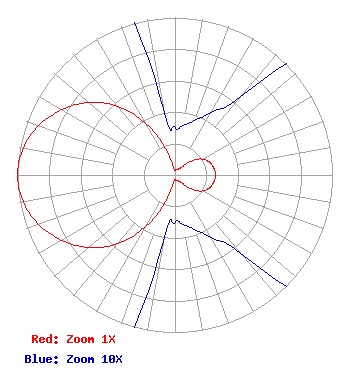 | ||||||||||||||||||
| Azimuth | Ratio | Azimuth | Ratio | Azimuth | Ratio | Azimuth | Ratio | ||||||||||||
| 0 | 0.030 | 10 | 0.032 | 20 | 0.037 | 30 | 0.046 | ||||||||||||
| 40 | 0.065 | 50 | 0.142 | 60 | 0.202 | 70 | 0.234 | ||||||||||||
| 80 | 0.250 | 90 | 0.260 | 100 | 0.250 | 110 | 0.234 | ||||||||||||
| 120 | 0.202 | 130 | 0.142 | 140 | 0.065 | 150 | 0.046 | ||||||||||||
| 160 | 0.037 | 170 | 0.032 | 180 | 0.030 | 190 | 0.045 | ||||||||||||
| 200 | 0.187 | 210 | 0.388 | 220 | 0.570 | 230 | 0.715 | ||||||||||||
| 240 | 0.829 | 250 | 0.920 | 260 | 0.979 | 270 | 1.000 | ||||||||||||
| 280 | 0.979 | 290 | 0.920 | 300 | 0.829 | 310 | 0.715 | ||||||||||||
| 320 | 0.570 | 330 | 0.388 | 340 | 0.187 | 350 | 0.045 | ||||||||||||
Structure Registration Number 1002037 [ASR Heights Differ from K277DS Application] Structure Type: GTOWER Registered To: Townsquare Media Billings, LLC Structure Address: 1736 Coburn Rd Billings, MT County Name: Yellowstone County ASR Issued: 02/13/2023 Date Built: 03/01/1979 Site Elevation: 1107.6 m (3634 ft.) Structure Height: 112 m (367 ft.) Height Overall: 112.8 m (370 ft.) Overall Height AMSL: 1220.4 m (4004 ft.) FAA Determination: 02/10/2023 FAA Study #: 2022-ANM-6327-OE FAA Circular #: 70/7460-1M Paint & Light FAA Chapters: 4, 8, 15 45-45-57.7 N 108-27-18.5 W (NAD 83) 45-45-57.9 N 108-27-16.0 W (Converted to NAD 27) |
1 Manhattanville Road Suite 202 Purchase, NY 10577 Phone: 203-861-0900 Limited Liability Company | Title: Senior Vice President Of Engineering Date: 11/03/2021 Application Certifier Townsquare License, Llc 1 Manhattanville Road Suite 202 Purchase, NY 10577 Applicant Howard Liberman Wilkinson Barker Knauer, Llp 1800 M Street, Nw Suite 800n Washington, DC 20036 Martin Stabbert Townsquare License, Llc 1 Manhattanville Road Suite 202 Purchase, NY 10577 Senior Vice President of Engineering JIM TURVAVILLE Turbo Tech Services 360 Patton Street - Po Box 144 Mobeetie, TX 79061 CONSULTING ENGINEER | |||||||||||||||||