
FCCInfo.com
A Service of Cavell, Mertz & Associates, Inc.
(855) FCC-INFO
|
|
|
|
|
||||||||||||||||
|
|
KUNE-FM Channel: 204C3 88.7 MHz Columbus, Nebraska Service: FM - A full-service FM station or application. Facility ID: 763016 Fac. Service: FM Status: Construction Permit Application Accepted: 11/09/2021 Application Granted: 03/01/2022 File Number: -0000165893 KUNE-FM CP Expires: 03/01/2025 Application Type: Non-Commercial Educational Amendment FCC Website Links: LMS Facility Details This Application Other KUNE-FM Applications Other KUNE-FM Applications in CDBS Including Superseded Applications Mailing Address Correspondence for KUNE-FM Correspondence related to application -0000165893 Service Contour - Open Street Map or USGS Map (60 dBu) Service Contour - KML / Google Earth (60 dBu) Public Inspection Files Facility Type: NON-COMMERCIAL EDUC. FM Class: C3, A Zone II station; with 6kW-25kW ERP and a class contour distance 28km-39km Site Location: 41-26-21.0 N 97-23-45.0 W (NAD 83) Site Location: 41-26-21.0 N 97-23-43.8 W (Converted to NAD 27) Effective Radiated Power: 10 kW Antenna Center HAAT: 51 m (167 ft.) Antenna Center AMSL: 503 m (1650 ft.) Antenna Center HAG: 58 m (190 ft.) Site Elevation: 445 m. (1460 ft.) Height Overall*: 87 m (285 ft.) (* As Filed In This Application, may differ from ASR Data, Below.) Directional Antenna Antenna Make/Model: None Antenna ID: 69-2019-08-06 Polarization: | ||||||||||||||||||
| Antenna Data for Antenna Id: 69-2019-08-06 KUNE-FM FM File: -0000165893 None - Service: FM | 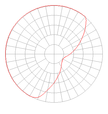 | ||||||||||||||||||
| Azimuth | Ratio | Azimuth | Ratio | Azimuth | Ratio | Azimuth | Ratio | ||||||||||||
| 0 | 1.000 | 10 | 1.000 | 20 | 1.000 | 30 | 1.000 | ||||||||||||
| 40 | 1.000 | 50 | 0.845 | 60 | 0.671 | 70 | 0.533 | ||||||||||||
| 80 | 0.423 | 90 | 0.336 | 100 | 0.267 | 110 | 0.225 | ||||||||||||
| 120 | 0.213 | 130 | 0.222 | 140 | 0.248 | 150 | 0.300 | ||||||||||||
| 160 | 0.378 | 170 | 0.475 | 180 | 0.599 | 190 | 0.754 | ||||||||||||
| 200 | 0.949 | 210 | 1.000 | 220 | 1.000 | 230 | 1.000 | ||||||||||||
| 240 | 1.000 | 250 | 1.000 | 260 | 1.000 | 270 | 1.000 | ||||||||||||
| 280 | 1.000 | 290 | 1.000 | 300 | 1.000 | 310 | 1.000 | ||||||||||||
| 320 | 1.000 | 330 | 1.000 | 340 | 1.000 | 350 | 1.000 | ||||||||||||
Structure Registration Number 1040699 Structure Type: LTOWER Registered To: PLATTE, COUNTY OF Structure Address: Sw1/4 Of Se1/4 Of Sect 14 Twp17n Range 1w Columbus, NE County Name: Platte County ASR Issued: 04/28/2023 Date Built: 01/01/1950 Site Elevation: 445.1 m (1460 ft.) Structure Height: 86.6 m (284 ft.) Height Overall: 86.6 m (284 ft.) Overall Height AMSL: 531.7 m (1744 ft.) FAA Determination: 12/14/2022 FAA Study #: 2022-ACE-7172-OE Paint & Light FAA Chapters: A1, H, 3, 11, 21, 23 PRIOR STUDY 1989-ACE-665-OE 41-26-21.6 N 97-23-48.1 W (NAD 83) 41-26-21.6 N 97-23-46.9 W (Converted to NAD 27) |
1800 N 33rd St. Lincoln, NE 68503 Phone: 402-472-9333 Government Entity | Title: Chief Technology Officer Date: 11/09/2021 Application Certifier Nebraska Educational Telecommunications Commission 1800 N 33rd St. Lincoln, NE 68503 Applicant Douglas Lee Vernier Doug Vernier, Telecommunications Consultants Doug Vernier Telecommunications Consultants 1600 Picturesque Dr Cedar Falls, IA 50613 Senior Broadcast Engineering Consultant & CEO Matthew Sperling Nebraska Educational Telecommunications Commission 1800 N 33rd St. Lincoln, NE 68503 Margaret L. Miller Gray Miller Persh, Llp 2233 Wisconsin Ave. Nw Suite 226 Washington, DC 20007 Partner | |||||||||||||||||