
FCCInfo.com
A Service of Cavell, Mertz & Associates, Inc.
(855) FCC-INFO
|
|
W281AR from 07/16/2008 W281AR from 03/16/2006 W281AR from 02/09/2006 W281AR from 06/16/2004 |
|
|
||||||||||||||||
|
|
W281AR Channel: 229D 93.7 MHz Williamsport, Pennsylvania Service: FX - A translator or application for a translator. Facility ID: 141440 Fac. Service: FX Programming Delivery Method: Unspecified Status: License Application Accepted: 11/10/2021 Application Granted: 12/08/2021 File Number: -0000168017 License Expires: 08/01/2022 Application Type: License To Cover FCC Website Links: LMS Facility Details This Application Other W281AR Applications Other W281AR Applications in CDBS Including Superseded Applications Mailing Address Correspondence for W281AR Correspondence related to application -0000168017 Service Contour - Open Street Map or USGS Map (60 dBu) Service Contour - KML / Google Earth (60 dBu) Facility Type: FM STATION Class: D, A Noncommercial educational operating with no more than 10W Site Location: 41-12-32.0 N 76-57-30.0 W (NAD 83) Site Location: 41-12-31.7 N 76-57-31.1 W (Converted to NAD 27) Effective Radiated Power: 0.25 kW Transmitter Output Power: 0.102 kW Antenna Center HAAT: 0 m Antenna Center AMSL: 635.1 m (2084 ft.) Antenna Center HAG: 30 m (98 ft.) Site Elevation: 605.1 m. (1985 ft.) Height Overall*: 65.5 m (215 ft.) (* As Filed In This Application, may differ from ASR Data, Below.) Directional Antenna Antenna Make/Model: Scala CA2-Slant 45 Antenna ID: 31326 Polarization: H
| ||||||||||||||||||
| Antenna Data for Antenna Id: 31326 W281AR FX File: -0000168017 Scala - CA2-Slant 45 Service: FX | 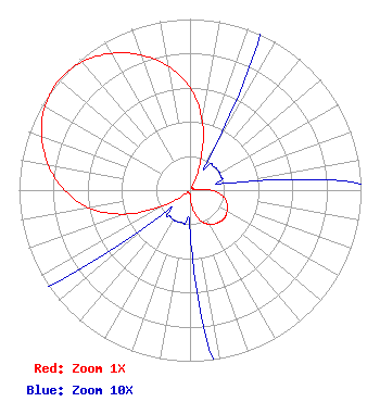 | ||||||||||||||||||
| Azimuth | Ratio | Azimuth | Ratio | Azimuth | Ratio | Azimuth | Ratio | ||||||||||||
| 0 | 0.600 | 10 | 0.410 | 20 | 0.185 | 30 | 0.030 | ||||||||||||
| 40 | 0.020 | 50 | 0.020 | 60 | 0.020 | 70 | 0.020 | ||||||||||||
| 80 | 0.025 | 90 | 0.125 | 100 | 0.195 | 110 | 0.230 | ||||||||||||
| 120 | 0.250 | 130 | 0.260 | 140 | 0.250 | 150 | 0.230 | ||||||||||||
| 160 | 0.195 | 170 | 0.125 | 180 | 0.025 | 190 | 0.020 | ||||||||||||
| 200 | 0.020 | 210 | 0.020 | 220 | 0.020 | 230 | 0.030 | ||||||||||||
| 240 | 0.185 | 250 | 0.410 | 260 | 0.600 | 270 | 0.735 | ||||||||||||
| 280 | 0.840 | 290 | 0.923 | 300 | 0.980 | 310 | 1.000 | ||||||||||||
| 320 | 0.980 | 330 | 0.923 | 340 | 0.840 | 350 | 0.735 | ||||||||||||
Structure Registration Number 1206694 Structure Type: TOWER Registered To: Industrial Electronics Structure Address: Bald Eagle Mountain Williamsport, PA County Name: Lycoming County ASR Issued: 01/30/2003 Date Built: 10/21/1999 Site Elevation: 605.1 m (1985 ft.) Structure Height: 65.5 m (215 ft.) Height Overall: 65.5 m (215 ft.) Overall Height AMSL: 670.6 m (2200 ft.) FAA Determination: 05/11/2001 FAA Study #: 01-AEA-1670-OE FAA Circular #: 70/7460-1K Paint & Light FAA Chapters: 4, 6, 12 41-12-32.0 N 76-57-30.0 W (NAD 83) 41-12-31.7 N 76-57-31.1 W (Converted to NAD 27) |
115 West Main Street Frankfort, KY 40601 Phone: 502-875-1130 Limited Liability Company | Title: President Date: 11/10/2021 Application Certifier SOUTHERN BELLE, LLC, Southern Belle, Llc 115 West Main Street Frankfort, KY 40601 Applicant Kevin M Fitzgerald Nyc Communications, Inc. Scranton, PA 18502 Allan G Moskowitz Allan G. Moskowitz 10845 Tuckahoe Way North Potomac, NJ 20878 Attorney | |||||||||||||||||