
FCCInfo.com
A Service of Cavell, Mertz & Associates, Inc.
(855) FCC-INFO
|
|
WBHX from 10/26/1992 |
|  |
|
|||||||||||||||
|
|
WBHX Channel: 259A 99.7 MHz Tuckerton, New Jersey Service: FM - A full-service FM station or application. Facility ID: 56233 Fac. Service: FM Status: License 73.215 Station Application Accepted: 12/08/2021 Application Granted: 02/02/2022 File Number: -0000176992 License Expires: 06/01/2022 Application Type: License To Cover FCC Website Links: LMS Facility Details This Application Other WBHX Applications Other WBHX Applications in CDBS Including Superseded Applications Mailing Address Correspondence for WBHX Correspondence related to application -0000176992 Service Contour - Open Street Map or USGS Map (60 dBu) Service Contour - KML / Google Earth (60 dBu) Public Inspection Files Facility Type: FM STATION Class: A, A Zone I; I-A; or II station; with 0.1kW-6kW ERP and a class contour distance <=28km Site Location: 39-37-53.4 N 74-21-10.1 W (NAD 83) Site Location: 39-37-53.0 N 74-21-11.6 W (Converted to NAD 27) Effective Radiated Power: 0.65 kW Transmitter Output Power: 5.8 kW Antenna Center HAAT: 178 m (584 ft.) Antenna Center AMSL: 186 m (610 ft.) Antenna Center HAG: 175 m (574 ft.) Site Elevation: 10.7 m. (35 ft.) Height Overall*: 304.8 m (1000 ft.) (* As Filed In This Application, may differ from ASR Data, Below.) Directional Antenna Antenna Make/Model: Electronics Research Inc. LP-2E-DA-HW Antenna ID: 1009002 Polarization: | ||||||||||||||||||
| Antenna Data for Antenna Id: 1009002 WBHX FM File: -0000176992 Electronics Research Inc. - LP-2E-DA-HW Service: FM | 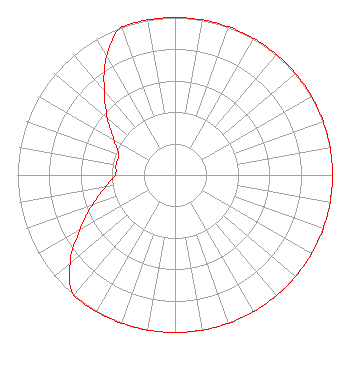 | ||||||||||||||||||
| Azimuth | Ratio | Azimuth | Ratio | Azimuth | Ratio | Azimuth | Ratio | ||||||||||||
| 0 | 1.000 | 10 | 1.000 | 20 | 1.000 | 30 | 1.000 | ||||||||||||
| 40 | 1.000 | 50 | 1.000 | 60 | 1.000 | 70 | 1.000 | ||||||||||||
| 80 | 1.000 | 90 | 1.000 | 100 | 1.000 | 110 | 1.000 | ||||||||||||
| 120 | 1.000 | 130 | 1.000 | 140 | 1.000 | 150 | 1.000 | ||||||||||||
| 160 | 1.000 | 170 | 1.000 | 180 | 1.000 | 190 | 1.000 | ||||||||||||
| 200 | 1.000 | 210 | 1.000 | 220 | 1.000 | 230 | 0.870 | ||||||||||||
| 240 | 0.700 | 250 | 0.560 | 260 | 0.450 | 270 | 0.380 | ||||||||||||
| 280 | 0.380 | 290 | 0.380 | 300 | 0.450 | 310 | 0.560 | ||||||||||||
| 320 | 0.700 | 330 | 0.870 | 340 | 1.000 | 350 | 1.000 | ||||||||||||
Structure Registration Number 1210613 Structure Type: GTOWER Registered To: CTI Towers Assets II, LLC Structure Address: 3.3 Km North Of Tuckerton, NJ County Name: Ocean County ASR Issued: 05/13/2022 Date Built: 01/01/2006 Site Elevation: 10.7 m (35 ft.) Structure Height: 303.6 m (996 ft.) Height Overall: 304.8 m (1000 ft.) Overall Height AMSL: 315.5 m (1035 ft.) FAA Determination: 06/21/2021 FAA Study #: 2020-AEA-12616-OE FAA Circular #: 70/7460-1M Paint & Light FAA Chapters: 4, 7, 15 PRIOR STUDY 1999-AEA-1528-OE 39-37-54.7 N 74-21-12.8 W (NAD 83) 39-37-54.3 N 74-21-14.3 W (Converted to NAD 27) |
201 Main Street Allenhurst, NJ 07711 Phone: 732-751-1119 Limited Liability Company | Title: Chief Operating And Financial Officer Date: 12/08/2021 Application Certifier PRESS COMMUNICATIONS, L.L.C. Press Communications, L.l.c. 201 Main Street Allenhurst, NJ 07711 Applicant Robert Silverman Womble Bond Dickinson (us) Llp 2001 K Street, Nw Suite 400 South Washington, DC 20006 Attorney Charles M. Anderson Charles M. Anderson & Associates 5900 Lake Cyrus Drive Hoover, AL 35244 BROADCAST ENGINEERING CONSULTANT | |||||||||||||||||