
FCCInfo.com
A Service of Cavell, Mertz & Associates, Inc.
(855) FCC-INFO
|
|
K267CY from 06/08/2018 |
|
|
||||||||||||||||
|
|
K267CY Channel: 267D 101.3 MHz Des Moines, Iowa Service: FX - A translator or application for a translator. Facility ID: 202727 Fac. Service: FX Programming Delivery Method: Unspecified Status: License Application Accepted: 12/01/2021 Application Granted: 12/14/2021 File Number: -0000175568 License Expires: 02/01/2028 Application Type: License To Cover FCC Website Links: LMS Facility Details This Application Other K267CY Applications Other K267CY Applications in CDBS Including Superseded Applications Mailing Address Correspondence for K267CY Correspondence related to application -0000175568 Service Contour - Open Street Map or USGS Map (60 dBu) Service Contour - KML / Google Earth (60 dBu) Facility Type: FM STATION Class: D, A Noncommercial educational operating with no more than 10W Site Location: 41-39-46.0 N 93-45-24.0 W (NAD 83) Site Location: 41-39-46.0 N 93-45-23.2 W (Converted to NAD 27) Effective Radiated Power: 0.13 kW Antenna Center HAAT: 0 m Antenna Center AMSL: 406.2 m (1333 ft.) Antenna Center HAG: 109.7 m (360 ft.) Site Elevation: 296.5 m. (973 ft.) Height Overall*: 146 m (479 ft.) (* As Filed In This Application, may differ from ASR Data, Below.) Directional Antenna Antenna Make/Model: NiCom BKG77-1 Antenna ID: 1006536 Polarization: H
| ||||||||||||||||||
| Antenna Data for Antenna Id: 1006536 K267CY FX File: -0000175568 NiCom - BKG77-1 Service: FX | 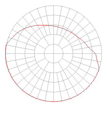 | ||||||||||||||||||
| Azimuth | Ratio | Azimuth | Ratio | Azimuth | Ratio | Azimuth | Ratio | ||||||||||||
| 0 | 0.571 | 10 | 0.558 | 20 | 0.553 | 30 | 0.558 | ||||||||||||
| 40 | 0.571 | 50 | 0.594 | 60 | 0.628 | 70 | 0.682 | ||||||||||||
| 80 | 0.738 | 90 | 0.862 | 100 | 0.923 | 110 | 1.000 | ||||||||||||
| 120 | 1.000 | 130 | 1.000 | 140 | 1.000 | 150 | 1.000 | ||||||||||||
| 160 | 1.000 | 170 | 1.000 | 180 | 1.000 | 190 | 1.000 | ||||||||||||
| 200 | 1.000 | 210 | 1.000 | 220 | 1.000 | 230 | 1.000 | ||||||||||||
| 240 | 1.000 | 250 | 1.000 | 260 | 1.000 | 270 | 1.000 | ||||||||||||
| 280 | 1.000 | 290 | 0.923 | 300 | 0.862 | 310 | 0.797 | ||||||||||||
| 320 | 0.731 | 330 | 0.676 | 340 | 0.628 | 350 | 0.594 | ||||||||||||
Structure Registration Number 1028735 Structure Type: TOWER Registered To: VB Nimbus, LLC Structure Address: 5650 Nw 100th St Des Moines, IA County Name: Polk County ASR Issued: 10/14/2020 Date Built: 06/01/1973 Site Elevation: 296.5 m (973 ft.) Structure Height: 145 m (476 ft.) Height Overall: 146 m (479 ft.) Overall Height AMSL: 442.5 m (1452 ft.) FAA Determination: 07/07/1997 FAA Study #: 97-ACE-0744-OE FAA Circular #: 70/7460-1J Paint & Light FAA Chapters: 3, 4, 5, 13 41-39-46.0 N 93-45-24.0 W (NAD 83) 41-39-46.0 N 93-45-23.2 W (Converted to NAD 27) |
3280 Peachtree Road, Nw Suite 2200 Atlanta, GA 30305 Phone: 404-949-0700 Limited Liability Company | Title: Executive Vice President And General Counsel Date: 12/01/2021 Application Certifier RADIO LICENSE HOLDING CBC, LLC Radio License Holding Cbc, Llc 3280 Peachtree Road, Nw Suite 2200 Atlanta, GA 30305 Applicant Mark N. Lipp, Esq Fletcher, Heald &hildreth, P.l.c. 1300 North 17th Street 11th Floor Arlington, VA 22209 FCC Counsel William J. Getz Carl T. Jones Corporation 7901 Yarnwood Ct Springfield, VA 22153 Consulting Engineer | |||||||||||||||||