
FCCInfo.com
A Service of Cavell, Mertz & Associates, Inc.
(855) FCC-INFO
|
|
|
|
|
||||||||||||||||
|
|
W263AI Channel: 263D 100.5 MHz Murfreesboro, Tennessee Service: FX - A translator or application for a translator. Facility ID: 77141 Fac. Service: FX Programming Delivery Method: Unspecified Status: License Application Accepted: 12/09/2021 Application Granted: 12/27/2021 File Number: -0000177052 License Expires: 08/01/2028 Application Type: License To Cover FCC Website Links: LMS Facility Details This Application Other W263AI Applications Other W263AI Applications in CDBS Including Superseded Applications Mailing Address Correspondence for W263AI Correspondence related to application -0000177052 Service Contour - Open Street Map or USGS Map (60 dBu) Service Contour - KML / Google Earth (60 dBu) Facility Type: FM STATION Class: D, A Noncommercial educational operating with no more than 10W Site Location: 35-58-55.2 N 86-34-57.9 W (NAD 83) Site Location: 35-58-55.0 N 86-34-57.9 W (Converted to NAD 27) Effective Radiated Power: 0.25 kW Transmitter Output Power: 0.78 kW Antenna Center HAAT: 0 m Antenna Center AMSL: 331.3 m (1087 ft.) Antenna Center HAG: 57 m (187 ft.) Site Elevation: 274.3 m. (900 ft.) Height Overall*: 60.7 m (199 ft.) (* As Filed In This Application, may differ from ASR Data, Below.) Directional Antenna Antenna Make/Model: SCALA HDCA5 Antenna ID: 120088 Polarization: H
| ||||||||||||||||||
| Antenna Data for Antenna Id: 120088 W263AI FX File: -0000177052 SCALA - HDCA5 Service: FX | 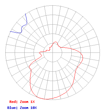 | ||||||||||||||||||
| Azimuth | Ratio | Azimuth | Ratio | Azimuth | Ratio | Azimuth | Ratio | ||||||||||||
| 0 | 0.169 | 10 | 0.218 | 20 | 0.235 | 30 | 0.214 | ||||||||||||
| 40 | 0.190 | 50 | 0.193 | 60 | 0.215 | 70 | 0.295 | ||||||||||||
| 80 | 0.426 | 90 | 0.580 | 100 | 0.651 | 110 | 0.641 | ||||||||||||
| 120 | 0.615 | 130 | 0.634 | 140 | 0.716 | 150 | 0.816 | ||||||||||||
| 160 | 0.881 | 170 | 0.929 | 180 | 0.971 | 190 | 1.000 | ||||||||||||
| 200 | 0.989 | 210 | 0.902 | 220 | 0.736 | 230 | 0.590 | ||||||||||||
| 240 | 0.555 | 250 | 0.266 | 260 | 0.247 | 270 | 0.274 | ||||||||||||
| 280 | 0.142 | 290 | 0.142 | 300 | 0.083 | 310 | 0.084 | ||||||||||||
| 320 | 0.084 | 330 | 0.119 | 340 | 0.120 | 350 | 0.131 | ||||||||||||
Structure Registration Number 1227349 Structure Type: TOWER Registered To: Middle Tennessee Two-way Inc Structure Address: Sanford Knob, 2 Miles South Of Lavergne, TN County Name: Rutherford County ASR Issued: 11/07/2021 Date Built: 11/16/2001 Site Elevation: 274.3 m (900 ft.) Structure Height: 60.7 m (199 ft.) Height Overall: 60.7 m (199 ft.) Overall Height AMSL: 335 m (1099 ft.) FAA Determination: 06/06/2001 FAA Study #: 01-ASO-3400-OE Paint & Light FAA Chapters: NONE PRIOR STUDY 83-AASO-1651-OE 35-58-55.2 N 86-34-57.9 W (NAD 83) 35-58-55.0 N 86-34-57.9 W (Converted to NAD 27) |
306 South Church Street Murfreesboro, TN 37130 Phone: 615-893-5373 Corporation | Title: President Date: 12/09/2021 Application Certifier THE RUTHERFORD GROUP, INC. The Rutherford Group, Inc. 306 South Church Street Murfreesboro, TN 37130 Applicant BART WALKER The Rutherford Group, Inc. 306 South Church Street Murfreesboro, TN 37130 Gary Brown Gary M. Brown Nashville, TN 37205 CHARLES M. ANDERSON Anderson Associates 5900 Lake Cyrus Drive Hoover, AL 35244 ENGINEERING CONSULTANT | |||||||||||||||||