
FCCInfo.com
A Service of Cavell, Mertz & Associates, Inc.
(855) FCC-INFO
|
|
WFME-FM from 02/23/2007 WFME-FM from 01/12/2004 WFME-FM from 07/01/1996 WFME-FM from 11/24/1987 |
|  |
|
|||||||||||||||
|
|
WFME-FM Channel: 224A 92.7 MHz Garden City, New York Service: FM - A full-service FM station or application. Facility ID: 30573 Fac. Service: FM Status: License 73.215 Station Application Accepted: 02/25/2022 Application Granted: 03/07/2022 File Number: -0000185409 License Expires: 06/01/2022 Application Type: Minor Modification FCC Website Links: LMS Facility Details This Application Other WFME-FM Applications Other WFME-FM Applications in CDBS Including Superseded Applications Mailing Address Correspondence for WFME-FM Correspondence related to application -0000185409 Service Contour - Open Street Map or USGS Map (60 dBu) Service Contour - KML / Google Earth (60 dBu) Public Inspection Files Facility Type: NON-COMMERCIAL EDUC. FM Class: A, A Zone I; I-A; or II station; with 0.1kW-6kW ERP and a class contour distance <=28km Site Location: 40-45-26.4 N 73-42-50.5 W (NAD 83) Site Location: 40-45-26.0 N 73-42-52.0 W (Converted to NAD 27) Effective Radiated Power: 2 kW Transmitter Output Power: 2.4 kW Antenna Center HAAT: 159 m (522 ft.) Antenna Center AMSL: 176 m (577 ft.) Antenna Center HAG: 104 m (341 ft.) Site Elevation: 72 m. (236 ft.) Height Overall*: 112 m (367 ft.) (* As Filed In This Application, may differ from ASR Data, Below.) Directional Antenna Antenna Make/Model: Harris SKMIED Antenna ID: 15806 Polarization: | ||||||||||||||||||
| Antenna Data for Antenna Id: 15806 WFME-FM FM File: -0000185409 Harris - SKMIED Service: FM | 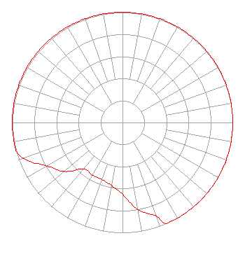 | ||||||||||||||||||
| Azimuth | Ratio | Azimuth | Ratio | Azimuth | Ratio | Azimuth | Ratio | ||||||||||||
| 0 | 1.000 | 10 | 1.000 | 20 | 1.000 | 30 | 1.000 | ||||||||||||
| 40 | 1.000 | 50 | 1.000 | 60 | 1.000 | 70 | 1.000 | ||||||||||||
| 80 | 1.000 | 90 | 1.000 | 100 | 1.000 | 110 | 1.000 | ||||||||||||
| 120 | 1.000 | 130 | 1.000 | 140 | 1.000 | 150 | 1.000 | ||||||||||||
| 157 | 1.000 | 160 | 0.900 | 170 | 0.800 | 180 | 0.650 | ||||||||||||
| 190 | 0.580 | 200 | 0.550 | 210 | 0.550 | 220 | 0.550 | ||||||||||||
| 230 | 0.690 | 240 | 0.790 | 250 | 0.950 | 255 | 1.000 | ||||||||||||
| 260 | 1.000 | 270 | 1.000 | 280 | 1.000 | 290 | 1.000 | ||||||||||||
| 300 | 1.000 | 310 | 1.000 | 320 | 1.000 | 330 | 1.000 | ||||||||||||
| 340 | 1.000 | 350 | 1.000 | ||||||||||||||||
Structure Registration Number 1043283 Structure Type: 3B Registered To: COMMUNICATIONS LEASING INC Structure Address: 271-10 Grand Central Parkway Queens, NY County Name: Queens County ASR Issued: 10/18/2006 Date Built: 01/01/1973 Site Elevation: 71.6 m (235 ft.) Structure Height: 105.7 m (347 ft.) Height Overall: 111.6 m (366 ft.) Overall Height AMSL: 183.2 m (601 ft.) FAA Determination: 01/04/1996 FAA Study #: 95-AEA-2091-OE FAA Circular #: 70/7460-1J Paint & Light FAA Chapters: 4, 5, 13 40-45-26.0 N 73-42-50.0 W (NAD 83) 40-45-25.6 N 73-42-51.5 W (Converted to NAD 27) |
112 North Elm Street Shenandoah, IA 51601 Phone: 712-246-5151 Not-for-Profit | Title: President Date: 02/25/2022 Application Certifier Family Stations, Inc. 112 North Elm Street Shenandoah, IA 51601 Applicant MATTHEW H. MCCORMICK, ESQ Fletcher, Heald, & Hildreth, P.l.c. 1300 North 17th Street, 11th Floor Arlington, VA 22209 Legal Counsel | |||||||||||||||||