
FCCInfo.com
A Service of Cavell, Mertz & Associates, Inc.
(855) FCC-INFO
|
|
|
|
|
||||||||||||||||
|
|
W242CD Channel: 242D 96.3 MHz Greensboro, North Carolina Service: FX - A translator or application for a translator. Facility ID: 142274 Fac. Service: FX Programming Delivery Method: Unspecified Status: Construction Permit Application Accepted: 02/11/2022 Application Granted: 02/25/2022 File Number: -0000184730 W242CD CP Expires: 02/25/2025 Application Type: Minor Modification FCC Website Links: LMS Facility Details This Application Other W242CD Applications Other W242CD Applications in CDBS Including Superseded Applications Mailing Address Correspondence for W242CD Correspondence related to application -0000184730 Service Contour - Open Street Map or USGS Map (60 dBu) Service Contour - KML / Google Earth (60 dBu) Facility Type: FM STATION Class: D, A Noncommercial educational operating with no more than 10W Site Location: 36-03-42.0 N 79-47-34.0 W (NAD 83) Site Location: 36-03-41.5 N 79-47-34.9 W (Converted to NAD 27) Effective Radiated Power: 0.25 kW Antenna Center HAAT: 0 m Antenna Center AMSL: 329 m (1079 ft.) Antenna Center HAG: 79 m (259 ft.) Site Elevation: 250 m. (820 ft.) Height Overall*: 81.4 m (267 ft.) (* As Filed In This Application, may differ from ASR Data, Below.) Directional Antenna Antenna Make/Model: Nicom BKG77 Antenna ID: 122413 Polarization: H
| ||||||||||||||||||
| Antenna Data for Antenna Id: 122413 W242CD FX File: -0000184730 Nicom - BKG77 Service: FX | 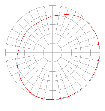 | ||||||||||||||||||
| Azimuth | Ratio | Azimuth | Ratio | Azimuth | Ratio | Azimuth | Ratio | ||||||||||||
| 0 | 0.772 | 10 | 0.802 | 20 | 0.853 | 30 | 0.909 | ||||||||||||
| 40 | 0.953 | 50 | 0.973 | 60 | 0.983 | 70 | 1.000 | ||||||||||||
| 80 | 0.992 | 90 | 0.988 | 100 | 0.988 | 110 | 0.983 | ||||||||||||
| 120 | 0.983 | 130 | 0.983 | 140 | 0.983 | 150 | 0.983 | ||||||||||||
| 160 | 0.988 | 170 | 0.988 | 180 | 0.992 | 190 | 1.000 | ||||||||||||
| 200 | 0.991 | 210 | 0.963 | 220 | 0.923 | 230 | 0.873 | ||||||||||||
| 240 | 0.832 | 250 | 0.792 | 260 | 0.762 | 270 | 0.732 | ||||||||||||
| 280 | 0.710 | 290 | 0.702 | 300 | 0.702 | 310 | 0.702 | ||||||||||||
| 320 | 0.702 | 330 | 0.702 | 340 | 0.712 | 350 | 0.732 | ||||||||||||
Structure Registration Number 1235239 Structure Type: TOWER Registered To: Truth Broadcasting Corporation Structure Address: South Eugene Street Greensboro, NC County Name: Guilford County ASR Issued: 05/16/2023 Date Built: 05/29/2003 Site Elevation: 250 m (820 ft.) Structure Height: 81.4 m (267 ft.) Height Overall: 81.4 m (267 ft.) Overall Height AMSL: 331.4 m (1087 ft.) FAA Determination: 07/29/2002 FAA Study #: 02-ASO-3885-OE FAA Circular #: 70/7460-1K Paint & Light FAA Chapters: 4, 8, 12 Removed expiration date from determination. Scenario 1./jjs/case#635066 36-03-42.0 N 79-47-34.0 W (NAD 83) 36-03-41.5 N 79-47-34.9 W (Converted to NAD 27) |
3780 Will Scarlet Road Winston-salem, NC 27104 Phone: 336-765-7438 Corporation | Title: President Date: 02/11/2022 Application Certifier DELMARVA EDUCATIONAL ASSOCIATION Delmarva Educational Association 3780 Will Scarlet Road Winston-salem, NC 27104 Applicant Donald A Lynch Horizon Broadcast Solutions, Llc 111 Sam Houston Dr. Kerrville, TX 78028 Davina Sashkin, Esq Bakerhostetler Llp 1050 Connecticut Avenue, Nw Suite 1100 Washington, DC 20036 | |||||||||||||||||