
FCCInfo.com
A Service of Cavell, Mertz & Associates, Inc.
(855) FCC-INFO
|
|
|
|  |
|
|||||||||||||||
|
|
KAIM-FM Channel: 238C 95.5 MHz Honolulu, Hawaii Service: FM - A full-service FM station or application. Facility ID: 10950 Fac. Service: FM Status: License Application Accepted: 02/18/2022 Application Granted: 06/21/2022 File Number: -0000185042 License Expires: 02/01/2030 Application Type: Minor Modification FCC Website Links: LMS Facility Details This Application Other KAIM-FM Applications Other KAIM-FM Applications in CDBS Including Superseded Applications Mailing Address Correspondence for KAIM-FM Correspondence related to application -0000185042 Service Contour - Open Street Map or USGS Map (60 dBu) Service Contour - KML / Google Earth (60 dBu) Public Inspection Files History Cards for KAIM-FM Facility Type: FM STATION Class: C, A Zone II station; with exactly 100kW ERP and a class contour distance 72km-92km Site Location: 21-23-33.6 N 158-05-48.1 W (NAD 83) Site Location: 21-23-45.0 N 158-05-58.0 W (Converted to NAD 27) Effective Radiated Power: 100 kW Transmitter Output Power: 3.6 kW Antenna Center HAAT: 565 m (1854 ft.) Antenna Center AMSL: 734 m (2408 ft.) Antenna Center HAG: 39 m (128 ft.) Site Elevation: 695.1 m. (2281 ft.) Height Overall*: 60.6 m (199 ft.) (* As Filed In This Application, may differ from ASR Data, Below.) Directional Antenna Antenna Make/Model: Shively 6014, 14 bays Antenna ID: 15906 Polarization: H | ||||||||||||||||||
| Antenna Data for Antenna Id: 15906 KAIM-FM FM File: -0000185042 Shively - 6014, 14 bays Service: FM | 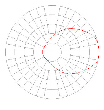 | ||||||||||||||||||
| Azimuth | Ratio | Azimuth | Ratio | Azimuth | Ratio | Azimuth | Ratio | ||||||||||||
| 0 | 0.325 | 10 | 0.390 | 20 | 0.470 | 30 | 0.560 | ||||||||||||
| 40 | 0.655 | 45 | 0.700 | 50 | 0.755 | 60 | 0.850 | ||||||||||||
| 70 | 0.955 | 80 | 1.000 | 90 | 1.000 | 100 | 1.000 | ||||||||||||
| 110 | 0.900 | 120 | 0.800 | 130 | 0.705 | 135 | 0.650 | ||||||||||||
| 140 | 0.605 | 150 | 0.510 | 160 | 0.410 | 170 | 0.330 | ||||||||||||
| 180 | 0.275 | 190 | 0.245 | 200 | 0.220 | 210 | 0.205 | ||||||||||||
| 220 | 0.200 | 230 | 0.200 | 240 | 0.200 | 250 | 0.200 | ||||||||||||
| 260 | 0.200 | 270 | 0.200 | 280 | 0.200 | 290 | 0.200 | ||||||||||||
| 300 | 0.200 | 310 | 0.200 | 320 | 0.200 | 330 | 0.215 | ||||||||||||
| 340 | 0.235 | 350 | 0.270 | ||||||||||||||||
Structure Registration Number 1218023 Structure Type: TOWER Registered To: Salem Media of Hawaii Structure Address: Palikea Ridge, 26.9 Km Nw Of Honolulu At 292° True Makakilo, HI County Name: Honolulu County ASR Issued: 10/03/2000 Date Built: 10/03/2000 Site Elevation: 695.1 m (2281 ft.) Structure Height: 60.6 m (199 ft.) Height Overall: 60.6 m (199 ft.) Overall Height AMSL: 755.7 m (2479 ft.) FAA Determination: 09/08/2000 FAA Study #: 00-AWP-2258-OE Paint & Light FAA Chapters: NONE 21-23-33.6 N 158-05-48.1 W (NAD 83) 21-23-45.0 N 158-05-58.0 W (Converted to NAD 27) |
4880 Santa Rosa Road Camarillo, CA 93012 Phone: 805-987-0400 Fax: 805-482-8570 Corporation | Title: Executive Vice President And Secretary Date: 02/18/2022 Application Certifier NEW INSPIRATION BROADCASTING COMPANY, INC. Salem Media Of Hawaii, Inc. 4880 Santa Rosa Road Camarillo, CA 93012 Phone: 805-482-8570 Applicant William J. Getz Carl T. Jones Corporation 7901 Yarnwood Ct Springfield, VA 22153 Consulting Engineer Kathleen Kirby Wiley Rein Llp 2050 M Street, Nw Washington, DC 20036 | |||||||||||||||||
| |||||||||||||||||||