
FCCInfo.com
A Service of Cavell, Mertz & Associates, Inc.
(855) FCC-INFO
|
|
|
|
|
||||||||||||||||
|
|
W249CN Channel: 249D 97.7 MHz Greensboro, North Carolina Service: FX - A translator or application for a translator. Facility ID: 142855 Fac. Service: FX Programming Delivery Method: Unspecified Status: Construction Permit Application Accepted: 04/12/2022 Application Granted: 05/06/2022 File Number: -0000189313 W249CN CP Expires: 05/05/2025 Application Type: Minor Modification FCC Website Links: LMS Facility Details This Application Other W249CN Applications Other W249CN Applications in CDBS Including Superseded Applications Mailing Address Correspondence for W249CN Correspondence related to application -0000189313 Service Contour - Open Street Map or USGS Map (60 dBu) Service Contour - KML / Google Earth (60 dBu) Facility Type: FM STATION Class: D, A Noncommercial educational operating with no more than 10W Site Location: 36-03-42.0 N 79-47-34.0 W (NAD 83) Site Location: 36-03-41.5 N 79-47-34.9 W (Converted to NAD 27) Effective Radiated Power: 0.045 kW Antenna Center HAAT: 0 m Antenna Center AMSL: 329 m (1079 ft.) Antenna Center HAG: 79 m (259 ft.) Site Elevation: 250 m. (820 ft.) Height Overall*: 81.4 m (267 ft.) (* As Filed In This Application, may differ from ASR Data, Below.) Directional Antenna Antenna Make/Model: NICOM BKG77 Antenna ID: 0 Polarization: H
| ||||||||||||||||||
| Antenna Data for Antenna Id: 0 W249CN FX File: -0000189313 NICOM - BKG77 Service: FX | 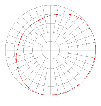 | ||||||||||||||||||
| Azimuth | Ratio | Azimuth | Ratio | Azimuth | Ratio | Azimuth | Ratio | ||||||||||||
| 0 | 0.772 | 10 | 0.802 | 20 | 0.853 | 30 | 0.909 | ||||||||||||
| 40 | 0.953 | 50 | 0.973 | 60 | 0.983 | 70 | 1.000 | ||||||||||||
| 80 | 0.992 | 90 | 0.988 | 100 | 0.988 | 110 | 0.983 | ||||||||||||
| 120 | 0.983 | 130 | 0.983 | 140 | 0.983 | 150 | 0.983 | ||||||||||||
| 160 | 0.988 | 170 | 0.988 | 180 | 0.992 | 190 | 1.000 | ||||||||||||
| 200 | 0.991 | 210 | 0.963 | 220 | 0.923 | 230 | 0.873 | ||||||||||||
| 240 | 0.832 | 250 | 0.792 | 260 | 0.762 | 270 | 0.732 | ||||||||||||
| 280 | 0.710 | 290 | 0.702 | 300 | 0.702 | 310 | 0.702 | ||||||||||||
| 320 | 0.702 | 330 | 0.702 | 340 | 0.712 | 350 | 0.732 | ||||||||||||
Structure Registration Number 1235239 Structure Type: TOWER Registered To: Truth Broadcasting Corporation Structure Address: South Eugene Street Greensboro, NC County Name: Guilford County ASR Issued: 05/16/2023 Date Built: 05/29/2003 Site Elevation: 250 m (820 ft.) Structure Height: 81.4 m (267 ft.) Height Overall: 81.4 m (267 ft.) Overall Height AMSL: 331.4 m (1087 ft.) FAA Determination: 07/29/2002 FAA Study #: 02-ASO-3885-OE FAA Circular #: 70/7460-1K Paint & Light FAA Chapters: 4, 8, 12 SUPPLEMENTAL NOTICE STATES STRUCTURE REACHED GREATEST HEIGHT ON 05/29/2003 36-03-42.0 N 79-47-34.0 W (NAD 83) 36-03-41.5 N 79-47-34.9 W (Converted to NAD 27) |
3012 Highwoods Blvd. Suite 201 Raleigh, NC 27604 Phone: 919-790-9392 Limited Liability Company | Title: Member And Manager Date: 04/12/2022 Application Certifier EASTERN AIRWAVES, LLC Eastern Airwaves, Llc 3012 Highwoods Blvd. Suite 201 Raleigh, NC 27604 Applicant Donald Lynch Horizon Broadcast Solutions, Llc 111 Sam Houston Dr. Kerrville, TX 78028 Coe W. Ramsey Brooks, Pierce Et Al. 150 Fayetteville Street Suite 1700 Raleigh, NC 27601 | |||||||||||||||||