
FCCInfo.com
A Service of Cavell, Mertz & Associates, Inc.
(855) FCC-INFO
|
|
W272EO from 01/11/2018 |
|
|
||||||||||||||||
|
|
W272EO Channel: 272D 102.3 MHz Lynchburg, Virginia Service: FX - A translator or application for a translator. Facility ID: 200986 Fac. Service: FX Programming Delivery Method: Unspecified Status: License Application Accepted: 03/28/2022 Application Granted: 04/14/2022 File Number: -0000187485 License Expires: 10/01/2027 Application Type: License To Cover FCC Website Links: LMS Facility Details This Application Other W272EO Applications Other W272EO Applications in CDBS Including Superseded Applications Mailing Address Correspondence for W272EO Correspondence related to application -0000187485 Service Contour - Open Street Map or USGS Map (60 dBu) Service Contour - KML / Google Earth (60 dBu) Facility Type: FM STATION Class: D, A Noncommercial educational operating with no more than 10W Site Location: 37-20-57.0 N 79-10-04.0 W (NAD 83) Site Location: 37-20-56.5 N 79-10-04.9 W (Converted to NAD 27) Effective Radiated Power: 0.12 kW Transmitter Output Power: 0.29 kW Antenna Center HAAT: 0 m Antenna Center AMSL: 433.1 m (1421 ft.) Antenna Center HAG: 18 m (59 ft.) Site Elevation: 415.1 m. (1362 ft.) Height Overall*: 24.4 m (80 ft.) (* As Filed In This Application, may differ from ASR Data, Below.) Directional Antenna Antenna Make/Model: Nicom BKG77 Antenna ID: 131701 Polarization: H
| ||||||||||||||||||
| Antenna Data for Antenna Id: 131701 W272EO FX File: -0000187485 Nicom - BKG77 Service: FX | 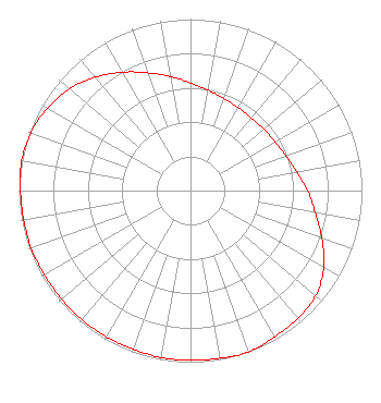 | ||||||||||||||||||
| Azimuth | Ratio | Azimuth | Ratio | Azimuth | Ratio | Azimuth | Ratio | ||||||||||||
| 0 | 0.628 | 10 | 0.594 | 20 | 0.571 | 30 | 0.558 | ||||||||||||
| 40 | 0.553 | 50 | 0.558 | 60 | 0.571 | 70 | 0.594 | ||||||||||||
| 80 | 0.628 | 90 | 0.682 | 100 | 0.738 | 110 | 0.815 | ||||||||||||
| 120 | 0.897 | 130 | 0.953 | 140 | 0.973 | 150 | 0.983 | ||||||||||||
| 160 | 1.000 | 170 | 0.992 | 180 | 0.988 | 190 | 0.988 | ||||||||||||
| 200 | 0.983 | 210 | 0.983 | 220 | 0.983 | 230 | 0.983 | ||||||||||||
| 240 | 0.983 | 250 | 0.988 | 260 | 0.988 | 270 | 0.992 | ||||||||||||
| 280 | 1.000 | 290 | 0.991 | 300 | 0.963 | 310 | 0.923 | ||||||||||||
| 320 | 0.862 | 330 | 0.797 | 340 | 0.731 | 350 | 0.676 | ||||||||||||
Structure Registration Number 1215021 Structure Type: Structure Address: On Top Of Candler's Mountain Lynchburg, VA County Name: Campbell County ASR Issued: 09/16/2015 Date Built: 08/29/1994 Site Elevation: 415.1 m (1362 ft.) Structure Height: 21 m (69 ft.) Height Overall: 24.4 m (80 ft.) Overall Height AMSL: 439.5 m (1442 ft.) FAA Determination: 06/29/1994 FAA Study #: 93-AEA-1491-OE FAA Circular #: 70/7460-1G Paint & Light FAA Chapters: 3, 4, 5, 9 37-20-57.0 N 79-10-04.0 W (NAD 83) 37-20-56.5 N 79-10-04.9 W (Converted to NAD 27) |
200 Frazier Road Altavista, VA 24517 Phone: 434-369-5588 Corporation | Title: Vice President Date: 03/28/2022 Application Certifier D.J. BROADCASTING, INC. D.j. Broadcasting, Inc. 200 Frazier Road Altavista, VA 24517 Applicant Bruce Bellamy Munn-reese Munn-reese Po Box 220 Coldwater, MI 49036 Consulting Engineer Patrick Cross Brooks, Pierce Et Al. 150 Fayetteville Street Suite 1700 Raleigh, NC 27601 Timothy G. Nelson Brooks, Pierce Et Al. 150 Fayetteville Street Suite 1700 Raleigh, NC 27601 | |||||||||||||||||