
FCCInfo.com
A Service of Cavell, Mertz & Associates, Inc.
(855) FCC-INFO
|
|
KBLX-FM3 from 01/04/2022 |
|
|
||||||||||||||||
|
|
KBLX-FM3 Channel: 275D 102.9 MHz Berkeley, California Service: FB - A booster station or application for a booster. Facility ID: 762863 Fac. Service: FB Programming Delivery Method: Unspecified Status: License Application Accepted: 04/25/2022 Application Granted: 04/29/2022 File Number: -0000189686 License Expires: 12/01/2029 Application Type: License To Cover FCC Website Links: LMS Facility Details This Application Other KBLX-FM3 Applications Other KBLX-FM3 Applications in CDBS Including Superseded Applications Mailing Address Correspondence for KBLX-FM3 Correspondence related to application -0000189686 Service Contour - Open Street Map or USGS Map (60 dBu) Service Contour - KML / Google Earth (60 dBu) Facility Type: FM STATION Class: D, A Noncommercial educational operating with no more than 10W Site Location: 37-52-56.5 N 122-13-15.1 W (NAD 83) Site Location: 37-52-56.8 N 122-13-11.2 W (Converted to NAD 27) Effective Radiated Power: 0.475 kW Antenna Center HAAT: 0 m Antenna Center AMSL: 582.9 m (1912 ft.) Antenna Center HAG: 30 m (98 ft.) Site Elevation: 552.9 m. (1814 ft.) Height Overall*: 63.1 m (207 ft.) (* As Filed In This Application, may differ from ASR Data, Below.) Directional Antenna Antenna Make/Model: Jampro JAVA 1-1 (2) Antenna ID: 1008811 Polarization: H
| ||||||||||||||||||
| Antenna Data for Antenna Id: 1008811 KBLX-FM3 FB File: -0000189686 Jampro - JAVA 1-1 (2) Service: FB | 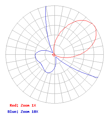 | ||||||||||||||||||
| Azimuth | Ratio | Azimuth | Ratio | Azimuth | Ratio | Azimuth | Ratio | ||||||||||||
| 0 | 0.212 | 10 | 0.370 | 20 | 0.560 | 30 | 0.753 | ||||||||||||
| 40 | 0.907 | 50 | 0.984 | 55 | 1.000 | 60 | 0.975 | ||||||||||||
| 70 | 0.881 | 80 | 0.717 | 90 | 0.521 | 100 | 0.335 | ||||||||||||
| 110 | 0.186 | 120 | 0.088 | 130 | 0.035 | 140 | 0.013 | ||||||||||||
| 150 | 0.006 | 160 | 0.008 | 170 | 0.017 | 180 | 0.028 | ||||||||||||
| 190 | 0.036 | 200 | 0.040 | 210 | 0.039 | 220 | 0.036 | ||||||||||||
| 230 | 0.034 | 240 | 0.034 | 250 | 0.037 | 260 | 0.039 | ||||||||||||
| 270 | 0.039 | 280 | 0.033 | 290 | 0.024 | 300 | 0.013 | ||||||||||||
| 310 | 0.006 | 320 | 0.006 | 330 | 0.015 | 340 | 0.042 | ||||||||||||
| 350 | 0.104 | ||||||||||||||||||
Structure Registration Number 1010568 Structure Type: TOWER Registered To: American Towers LLC Structure Address: Near Intersection Of Seaview Ln And Grizzly Peak Blvd (volmer Peak #8254--gld) Orinda, CA County Name: Contra Costa County ASR Issued: 01/15/2013 Date Built: 09/10/2001 Site Elevation: 552.9 m (1814 ft.) Structure Height: 61 m (200 ft.) Height Overall: 63.1 m (207 ft.) Overall Height AMSL: 616 m (2021 ft.) FAA Determination: 04/30/2008 FAA Study #: 2008-AWP-2409-OE FAA Circular #: 70/7460-1K Paint & Light FAA Chapters: 4, 8, 12 PRIOR STUDY 2002-AWP-1931-OE 37-52-56.5 N 122-13-15.1 W (NAD 83) 37-52-56.8 N 122-13-11.2 W (Converted to NAD 27) |
55 North 300 West 2nd Floor Salt Lake City, UT 84101 Phone: 801-575-5872 Corporation | Title: Vice President And General Counsel Date: 04/25/2022 Application Certifier Bonneville International Corporation 55 North 300 West 2nd Floor Salt Lake City, UT 84101 Applicant Kenneth E. Satten Wilkinson Barker Knauer, Llp 1800 M Street, Nw Suite 800n Washington, DC 20036 FCC Counsel Bert Goldman Goldman Engineering Management 560 Perkins Way Auburn, CA 95603 Technical Consultant | |||||||||||||||||