
FCCInfo.com
A Service of Cavell, Mertz & Associates, Inc.
(855) FCC-INFO
|
|
W262CC from 11/03/2011 W262CC from 08/30/2011 W262CC from 08/23/2007 W262CC from 09/21/2004 |
|
|
||||||||||||||||
|
|
W262CC Channel: 262D 100.3 MHz Tallahassee, Florida Service: FX - A translator or application for a translator. Facility ID: 148289 Fac. Service: FX Programming Delivery Method: Unspecified Status: License Application Accepted: 05/02/2022 Application Granted: 05/19/2022 File Number: -0000189920 License Expires: 02/01/2028 Application Type: License To Cover FCC Website Links: LMS Facility Details This Application Other W262CC Applications Other W262CC Applications in CDBS Including Superseded Applications Mailing Address Correspondence for W262CC Correspondence related to application -0000189920 Service Contour - Open Street Map or USGS Map (60 dBu) Service Contour - KML / Google Earth (60 dBu) Facility Type: NON-COMMERCIAL EDUC. FM Class: D, A Noncommercial educational operating with no more than 10W Site Location: 30-29-33.1 N 84-17-12.7 W (NAD 83) Site Location: 30-29-32.4 N 84-17-13.1 W (Converted to NAD 27) Effective Radiated Power: 0.099 kW Transmitter Output Power: 0.077 kW Antenna Center HAAT: 0 m Antenna Center AMSL: 209.8 m (688 ft.) Antenna Center HAG: 144 m (472 ft.) Site Elevation: 65.8 m. (216 ft.) Height Overall*: 145.9 m (479 ft.) (* As Filed In This Application, may differ from ASR Data, Below.) Directional Antenna Antenna Make/Model: Nicom BKG77 Antenna ID: 125005 Polarization: H
| ||||||||||||||||||
| Antenna Data for Antenna Id: 125005 W262CC FX File: -0000189920 Nicom - BKG77 Service: FX | 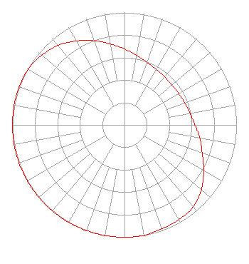 | ||||||||||||||||||
| Azimuth | Ratio | Azimuth | Ratio | Azimuth | Ratio | Azimuth | Ratio | ||||||||||||
| 0 | 0.676 | 10 | 0.628 | 20 | 0.594 | 30 | 0.571 | ||||||||||||
| 40 | 0.558 | 50 | 0.553 | 60 | 0.558 | 70 | 0.571 | ||||||||||||
| 80 | 0.594 | 90 | 0.628 | 100 | 0.682 | 110 | 0.738 | ||||||||||||
| 120 | 0.815 | 130 | 0.897 | 140 | 0.953 | 150 | 0.973 | ||||||||||||
| 160 | 0.983 | 170 | 1.000 | 180 | 1.000 | 190 | 1.000 | ||||||||||||
| 200 | 1.000 | 210 | 1.000 | 220 | 1.000 | 230 | 1.000 | ||||||||||||
| 240 | 1.000 | 250 | 1.000 | 260 | 1.000 | 270 | 1.000 | ||||||||||||
| 280 | 1.000 | 290 | 1.000 | 300 | 0.991 | 310 | 0.963 | ||||||||||||
| 320 | 0.923 | 330 | 0.862 | 340 | 0.797 | 350 | 0.731 | ||||||||||||
Structure Registration Number 1030925 Structure Type: GTOWER Registered To: Crown Castle South LLC Structure Address: Twr 1 - 123 Ridgeland Rd Tallahassee, FL County Name: Leon County ASR Issued: 05/06/2016 Date Built: 12/23/2008 Site Elevation: 65.8 m (216 ft.) Structure Height: 145.7 m (478 ft.) Height Overall: 145.9 m (479 ft.) Overall Height AMSL: 211.7 m (695 ft.) FAA Determination: 02/05/2009 FAA Study #: 2009-ASO-525-OE FAA Circular #: 70/7460-1K Paint & Light FAA Chapters: 4, 8, 12 PRIOR STUDY 2008-ASO-5385-OE 30-29-33.1 N 84-17-12.7 W (NAD 83) 30-29-32.4 N 84-17-13.1 W (Converted to NAD 27) |
7136 S. Yale Avenue Suite 501 Tulsa, OK 74136-6373 Phone: 918-388-5218 Limited Liability Company | Title: General Manager Date: 05/02/2022 Application Certifier Piedmont Communications, Inc. Piedmont Communications, Inc. P.o. Box 271 Orange, VA 22960 Applicant Patrick Cross Brooks, Pierce, Et Al. 150 Fayetteville Street Suite 1700 Raleigh, NC 27601 Legal Representative | |||||||||||||||||