
FCCInfo.com
A Service of Cavell, Mertz & Associates, Inc.
(855) FCC-INFO
|
|
|
|
|
||||||||||||||||
|
|
Channel: 220A 91.9 MHz Clarksville, Arkansas Service: FM - A full-service FM station or application. Facility ID: 767530 Fac. Service: FM Status: Construction Permit Application Accepted: 08/05/2022 Application Granted: 08/11/2022 File Number: -0000166778 CP Expires: 08/11/2025 Application Type: Non-Commercial Educational Amendment FCC Website Links: LMS Facility Details This Application Other Applications Other Applications in CDBS Including Superseded Applications Mailing Address Correspondence for Correspondence related to application -0000166778 Service Contour - Open Street Map or USGS Map (60 dBu) Service Contour - KML / Google Earth (60 dBu) Facility Type: NON-COMMERCIAL EDUC. FM Class: A, A Zone I; I-A; or II station; with 0.1kW-6kW ERP and a class contour distance <=28km Site Location: 35-27-40.0 N 93-26-52.0 W (NAD 83) Site Location: 35-27-39.7 N 93-26-51.3 W (Converted to NAD 27) Effective Radiated Power: 1.4 kW Antenna Center HAAT: -7 m Antenna Center AMSL: 157 m (515 ft.) Antenna Center HAG: 17 m (56 ft.) Site Elevation: 140 m. (459 ft.) Height Overall*: 18 m (59 ft.) (* As Filed In This Application, may differ from ASR Data, Below.) Directional Antenna Antenna Make/Model: None Antenna ID: 0 Polarization: H | ||||||||||||||||||
| Antenna Data for Antenna Id: 0 FM File: -0000166778 None - Service: FM | 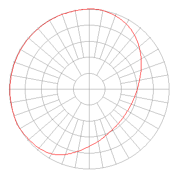 | ||||||||||||||||||
| Azimuth | Ratio | Azimuth | Ratio | Azimuth | Ratio | Azimuth | Ratio | ||||||||||||
| 0 | 0.998 | 4 | 1.000 | 10 | 0.994 | 20 | 0.971 | ||||||||||||
| 30 | 0.935 | 40 | 0.880 | 50 | 0.817 | 60 | 0.751 | ||||||||||||
| 70 | 0.692 | 80 | 0.642 | 90 | 0.604 | 100 | 0.578 | ||||||||||||
| 110 | 0.562 | 120 | 0.554 | 130 | 0.557 | 140 | 0.567 | ||||||||||||
| 150 | 0.587 | 160 | 0.618 | 170 | 0.666 | 180 | 0.721 | ||||||||||||
| 190 | 0.792 | 200 | 0.872 | 210 | 0.936 | 220 | 0.967 | ||||||||||||
| 230 | 0.980 | 240 | 0.995 | 244 | 1.000 | 250 | 0.994 | ||||||||||||
| 260 | 0.989 | 270 | 0.988 | 280 | 0.984 | 290 | 0.983 | ||||||||||||
| 300 | 0.983 | 310 | 0.983 | 320 | 0.983 | 330 | 0.986 | ||||||||||||
| 340 | 0.988 | 350 | 0.991 | ||||||||||||||||
Structure Registration Number 1322656 Structure Type: LTOWER Registered To: Johnson County Community Radio Inc. Structure Address: 50 White Drive Clarksville, AR County Name: Johnson County ASR Issued: 07/03/2022 Site Elevation: 140 m (459 ft.) Structure Height: 18 m (59 ft.) Height Overall: 18 m (59 ft.) Overall Height AMSL: 158 m (518 ft.) FAA Determination: 03/24/2022 FAA Study #: 2022-ASW-3323-OE Paint & Light FAA Chapters: NONE 35-27-39.7 N 93-26-51.8 W (NAD 83) 35-27-39.4 N 93-26-51.1 W (Converted to NAD 27) |
50 White Drive Clarksville, AR 72830 Phone: 479-647-0134 Not-for-Profit | Title: President Date: 08/05/2022 Application Certifier Johnson County Community Radio Inc. 50 White Drive Clarksville, AR 72830 Applicant SAMUEL SCOTT, MR Johnson County Community Radio Inc. 50 White Drive Clarksville, AR 72830 MANAGING MEMBER | |||||||||||||||||