
FCCInfo.com
A Service of Cavell, Mertz & Associates, Inc.
(855) FCC-INFO
|
|
W300BT from 03/19/2008 W300BT from 01/22/2008 W300BT from 10/30/2007 W300BT from 06/25/2004 |
|
|
||||||||||||||||
|
|
W300BT Channel: 300D 107.9 MHz Hazleton, Pennsylvania Service: FX - A translator or application for a translator. Facility ID: 156246 Fac. Service: FX Programming Delivery Method: Unspecified Status: License Application Accepted: 08/08/2022 Application Granted: 08/09/2022 File Number: -0000197151 License Expires: 08/01/2030 Application Type: License To Cover FCC Website Links: LMS Facility Details This Application Other W300BT Applications Other W300BT Applications in CDBS Including Superseded Applications Mailing Address Correspondence for W300BT Correspondence related to application -0000197151 Service Contour - Open Street Map or USGS Map (60 dBu) Service Contour - KML / Google Earth (60 dBu) Facility Type: FM STATION Class: D, A Noncommercial educational operating with no more than 10W Site Location: 40-58-08.9 N 75-57-27.1 W (NAD 83) Site Location: 40-58-08.6 N 75-57-28.4 W (Converted to NAD 27) Effective Radiated Power: 0.25 kW Transmitter Output Power: 0.011 kW Antenna Center HAAT: 0 m Antenna Center AMSL: 614.9 m (2017 ft.) Antenna Center HAG: 45 m (148 ft.) Site Elevation: 569.9 m. (1870 ft.) Height Overall*: 60.7 m (199 ft.) (* As Filed In This Application, may differ from ASR Data, Below.) Directional Antenna Antenna Make/Model: KATHREIN CA2-FM Antenna ID: 130703 Polarization: H
| ||||||||||||||||||
| Antenna Data for Antenna Id: 130703 W300BT FX File: -0000197151 KATHREIN - CA2-FM Service: FX | 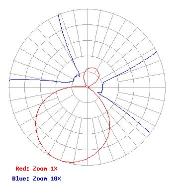 | ||||||||||||||||||
| Azimuth | Ratio | Azimuth | Ratio | Azimuth | Ratio | Azimuth | Ratio | ||||||||||||
| 0 | 0.227 | 10 | 0.248 | 20 | 0.259 | 30 | 0.251 | ||||||||||||
| 40 | 0.232 | 50 | 0.198 | 60 | 0.132 | 70 | 0.035 | ||||||||||||
| 80 | 0.021 | 90 | 0.020 | 100 | 0.020 | 110 | 0.020 | ||||||||||||
| 120 | 0.029 | 130 | 0.170 | 140 | 0.387 | 150 | 0.581 | ||||||||||||
| 160 | 0.722 | 170 | 0.829 | 180 | 0.915 | 190 | 0.974 | ||||||||||||
| 200 | 0.998 | 210 | 0.982 | 220 | 0.929 | 230 | 0.848 | ||||||||||||
| 240 | 0.746 | 250 | 0.613 | 260 | 0.429 | 270 | 0.208 | ||||||||||||
| 280 | 0.045 | 290 | 0.021 | 300 | 0.020 | 310 | 0.020 | ||||||||||||
| 320 | 0.020 | 330 | 0.025 | 340 | 0.115 | 350 | 0.188 | ||||||||||||
Structure Registration Number 1232866 Structure Type: TOWER Registered To: Jordan Realty Structure Address: Pardee Street Hazleton, PA County Name: Luzerne County ASR Issued: 03/13/2002 Date Built: 03/21/2003 Site Elevation: 569.9 m (1870 ft.) Structure Height: 54.8 m (180 ft.) Height Overall: 60.7 m (199 ft.) Overall Height AMSL: 630.6 m (2069 ft.) FAA Determination: 02/20/2002 FAA Study #: 01-AEA-4442-OE Paint & Light FAA Chapters: A1, H, 3, 11, 21, 23 OM&L TO REMAIN MED DUAL SYSTEM AS PER PRIOR STUDY 01-AEA-2686-OE 40-58-08.9 N 75-57-27.1 W (NAD 83) 40-58-08.6 N 75-57-28.4 W (Converted to NAD 27) |
Allentown, PA 18103 Phone: 610-905-8649 Individual | Title: Owner Date: 08/08/2022 Application Certifier OSIRIS FERNANDO GUZMAN 544 East Emmaus Avenue Allentown, PA 18103 Applicant ANTHONY T LEPORE, ESQ Radiotvlaw Associates, Llc 4101 Albemarle St Nw #324 Washington, DC 20016 | |||||||||||||||||