
FCCInfo.com
A Service of Cavell, Mertz & Associates, Inc.
(855) FCC-INFO
|
|
|
|  |
|
|||||||||||||||
|
|
WBSB Channel: 208A 89.5 MHz Anderson, Indiana Service: FM - A full-service FM station or application. Facility ID: 3650 Fac. Service: FM Status: Construction Permit Application Accepted: 09/21/2022 Application Granted: 10/31/2022 File Number: -0000200676 WBSB CP Expires: 10/31/2025 Application Type: Minor Modification FCC Website Links: LMS Facility Details This Application Other WBSB Applications Other WBSB Applications in CDBS Including Superseded Applications Mailing Address Correspondence for WBSB Correspondence related to application -0000200676 Service Contour - Open Street Map or USGS Map (60 dBu) Service Contour - KML / Google Earth (60 dBu) Public Inspection Files Facility Type: NON-COMMERCIAL EDUC. FM Class: A, A Zone I; I-A; or II station; with 0.1kW-6kW ERP and a class contour distance <=28km Site Location: 40-05-37.0 N 85-23-32.0 W (NAD 83) Site Location: 40-05-36.8 N 85-23-32.1 W (Converted to NAD 27) Effective Radiated Power: 1.3 kW Antenna Center HAAT: 197 m (646 ft.) Antenna Center AMSL: 503 m (1650 ft.) Antenna Center HAG: 200 m (656 ft.) Site Elevation: 303 m. (994 ft.) Height Overall*: 259 m (850 ft.) (* As Filed In This Application, may differ from ASR Data, Below.) Directional Antenna Antenna Make/Model: None Antenna ID: 1006063 Polarization: | ||||||||||||||||||
| Antenna Data for Antenna Id: 1006063 WBSB FM File: -0000200676 None - Service: FM | 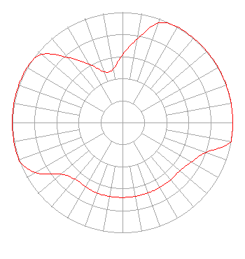 | ||||||||||||||||||
| Azimuth | Ratio | Azimuth | Ratio | Azimuth | Ratio | Azimuth | Ratio | ||||||||||||
| 0 | 0.615 | 10 | 0.770 | 20 | 0.960 | 30 | 1.000 | ||||||||||||
| 40 | 1.000 | 50 | 1.000 | 60 | 1.000 | 70 | 1.000 | ||||||||||||
| 80 | 1.000 | 90 | 1.000 | 100 | 1.000 | 110 | 0.800 | ||||||||||||
| 120 | 0.720 | 130 | 0.680 | 140 | 0.680 | 150 | 0.680 | ||||||||||||
| 160 | 0.680 | 170 | 0.680 | 180 | 0.680 | 190 | 0.680 | ||||||||||||
| 200 | 0.680 | 210 | 0.670 | 220 | 0.670 | 230 | 0.730 | ||||||||||||
| 240 | 0.910 | 250 | 1.000 | 260 | 1.000 | 270 | 1.000 | ||||||||||||
| 280 | 1.000 | 290 | 1.000 | 300 | 1.000 | 310 | 0.960 | ||||||||||||
| 320 | 0.770 | 330 | 0.615 | 340 | 0.490 | 350 | 0.490 | ||||||||||||
Structure Registration Number 1243031 Structure Type: Registered To: Ball State University Structure Address: The Tower Is Located At The Intersection Of Cr 50 W And Cr 700 S. Muncie, IN County Name: Delaware County ASR Issued: 05/12/2021 Date Built: 09/06/2005 Site Elevation: 303 m (994 ft.) Structure Height: 244 m (801 ft.) Height Overall: 259 m (850 ft.) Overall Height AMSL: 562 m (1844 ft.) FAA Determination: 10/09/2003 FAA Study #: 2003-AGL-1451-OE FAA Circular #: 70/7460-1K Paint & Light FAA Chapters: 4, 9, 12 Removed expiration and final dates from determination. Scenario 2./jjs/case#635066 40-05-37.0 N 85-23-32.0 W (NAD 83) 40-05-36.8 N 85-23-32.1 W (Converted to NAD 27) |
Ball State University 2000 W University Ave. Lb128 Muncie, IN 47306 Phone: 765-285-9116 Government Entity | Title: Chief Engineer Date: 09/21/2022 Application Certifier Ball State University Ball State University 2000 W University Ave. Lb128 Muncie, IN 47306 Applicant Benjamin Pidek, P.E Ben Pidek Consulting, Llc 7670 Coventry Dr. Temperance, MI 48182 Consulting Engineer Brad Deutsch Foster Garvey Pc 1000 Potomac St. Nw Suite 200 Washington, DC 20007 | |||||||||||||||||