
FCCInfo.com
A Service of Cavell, Mertz & Associates, Inc.
(855) FCC-INFO
|
|
K231CZ from 09/03/2014 |
|
|
||||||||||||||||
|
|
K231CZ Channel: 231D 94.1 MHz Austin, Texas Service: FX - A translator or application for a translator. Facility ID: 148525 Fac. Service: FX Programming Delivery Method: Unspecified Status: License Application Accepted: 10/04/2022 Application Granted: 10/18/2022 File Number: -0000201940 License Expires: 08/01/2029 Application Type: License To Cover FCC Website Links: LMS Facility Details This Application Other K231CZ Applications Other K231CZ Applications in CDBS Including Superseded Applications Mailing Address Correspondence for K231CZ Correspondence related to application -0000201940 Service Contour - Open Street Map or USGS Map (60 dBu) Service Contour - KML / Google Earth (60 dBu) Facility Type: FM STATION Class: D, A Noncommercial educational operating with no more than 10W Site Location: 30-19-24.0 N 97-47-59.7 W (NAD 83) Site Location: 30-19-23.3 N 97-47-58.7 W (Converted to NAD 27) Effective Radiated Power: 0 kW Horiz. ; 0.25 kW Vert. Transmitter Output Power: 0.24 kW Antenna Center HAAT: 0 m Antenna Center AMSL: 0 m Horiz.; 447.3 m Vert. Antenna Center HAG: 0 m Horiz.; 198 m Vert. Site Elevation: 249.3 m. (818 ft.) Height Overall*: 206 m (676 ft.) (* As Filed In This Application, may differ from ASR Data, Below.) Directional Antenna Antenna Make/Model: Kathrein CLFMV Antenna ID: 129550 Polarization: H
| ||||||||||||||||||
| Antenna Data for Antenna Id: 129550 K231CZ FX File: -0000201940 Kathrein - CLFMV Service: FX | 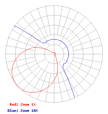 | ||||||||||||||||||
| Azimuth | Ratio | Azimuth | Ratio | Azimuth | Ratio | Azimuth | Ratio | ||||||||||||
| 0 | 0.030 | 10 | 0.030 | 20 | 0.030 | 30 | 0.030 | ||||||||||||
| 40 | 0.030 | 50 | 0.030 | 60 | 0.030 | 70 | 0.030 | ||||||||||||
| 80 | 0.030 | 90 | 0.030 | 100 | 0.030 | 110 | 0.030 | ||||||||||||
| 120 | 0.030 | 130 | 0.030 | 140 | 0.030 | 150 | 0.050 | ||||||||||||
| 160 | 0.190 | 170 | 0.390 | 180 | 0.544 | 190 | 0.690 | ||||||||||||
| 200 | 0.818 | 210 | 0.916 | 220 | 0.980 | 230 | 1.000 | ||||||||||||
| 240 | 0.980 | 250 | 0.916 | 260 | 0.818 | 270 | 0.690 | ||||||||||||
| 280 | 0.544 | 290 | 0.390 | 300 | 0.190 | 310 | 0.050 | ||||||||||||
| 320 | 0.030 | 330 | 0.030 | 340 | 0.030 | 350 | 0.030 | ||||||||||||
Structure Registration Number 1226714 Structure Type: TOWER Registered To: American Towers LLC Structure Address: 5319 Buckman Mountain Rd. (austin B #30309) Austin, TX County Name: Travis County ASR Issued: 06/24/2016 Date Built: 12/31/1996 Site Elevation: 249.3 m (818 ft.) Structure Height: 201.5 m (661 ft.) Height Overall: 206 m (676 ft.) Overall Height AMSL: 455.3 m (1494 ft.) FAA Determination: 06/29/2005 FAA Study #: 2005-ASW-2954-OE Paint & Light FAA Chapters: NONE PRIOR STUDY 2001-ASW-2523-OE 30-19-24.0 N 97-47-59.7 W (NAD 83) 30-19-23.3 N 97-47-58.7 W (Converted to NAD 27) |
2215 Cedar Springs Rd. #1605 Dallas, TX 75201 Phone: 214-709-1605 General Partnership | Title: Member Date: 10/04/2022 Application Certifier 94.1 Partnership 2215 Cedar Springs Rd. #1605 Dallas, TX 75201 Applicant Charles Crawford 94.1 Partnership 2215 Cedar Springs Rd. #1605 Dallas, TX 75201 Charles Staples Cs Broadcast Technical Services, Inc 4424 Glenwick Lane University Park, TX 75205 | |||||||||||||||||