
FCCInfo.com
A Service of Cavell, Mertz & Associates, Inc.
(855) FCC-INFO
|
|
|
|
|
||||||||||||||||
|
|
K257AF Channel: 257D 99.3 MHz Butte, Montana Service: FX - A translator or application for a translator. Facility ID: 69373 Fac. Service: FX Programming Delivery Method: Unspecified Status: Construction Permit Application Accepted: 11/07/2022 Application Granted: 11/28/2022 File Number: -0000203294 K257AF CP Expires: 11/27/2025 Application Type: Minor Modification FCC Website Links: LMS Facility Details This Application Other K257AF Applications Other K257AF Applications in CDBS Including Superseded Applications Mailing Address Correspondence for K257AF Correspondence related to application -0000203294 Service Contour - Open Street Map or USGS Map (60 dBu) Service Contour - KML / Google Earth (60 dBu) Facility Type: FM STATION Class: D, A Noncommercial educational operating with no more than 10W Site Location: 46-00-23.0 N 112-26-31.0 W (NAD 83) Site Location: 46-00-23.3 N 112-26-27.9 W (Converted to NAD 27) Effective Radiated Power: 0.25 kW Antenna Center HAAT: 549 m Horiz.; 0 m Vert. Antenna Center AMSL: 2531.3 m (8305 ft.) Antenna Center HAG: 35 m (115 ft.) Site Elevation: 2496.3 m. (8190 ft.) Height Overall*: 61.9 m (203 ft.) (* As Filed In This Application, may differ from ASR Data, Below.) Directional Antenna Antenna Make/Model: Nicom BKY3P Antenna ID: 0 Polarization: H
| ||||||||||||||||||
| Antenna Data for Antenna Id: 0 K257AF FX File: -0000203294 Nicom - BKY3P Service: FX | 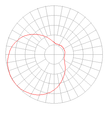 | ||||||||||||||||||
| Azimuth | Ratio | Azimuth | Ratio | Azimuth | Ratio | Azimuth | Ratio | ||||||||||||
| 0 | 0.250 | 10 | 0.220 | 20 | 0.220 | 30 | 0.220 | ||||||||||||
| 40 | 0.230 | 50 | 0.230 | 60 | 0.230 | 70 | 0.230 | ||||||||||||
| 80 | 0.230 | 90 | 0.220 | 100 | 0.220 | 110 | 0.220 | ||||||||||||
| 120 | 0.250 | 130 | 0.290 | 140 | 0.360 | 150 | 0.440 | ||||||||||||
| 160 | 0.530 | 170 | 0.630 | 180 | 0.730 | 190 | 0.810 | ||||||||||||
| 200 | 0.880 | 210 | 0.930 | 220 | 0.970 | 230 | 0.990 | ||||||||||||
| 240 | 1.000 | 250 | 0.990 | 260 | 0.970 | 270 | 0.930 | ||||||||||||
| 280 | 0.880 | 290 | 0.810 | 300 | 0.730 | 310 | 0.630 | ||||||||||||
| 320 | 0.530 | 330 | 0.440 | 340 | 0.360 | 350 | 0.290 | ||||||||||||
Structure Registration Number 1031582 Structure Type: TOWER Registered To: BUTTE BROADCASTING Structure Address: Sw 1/4 Of Section 14, Township 3 N. Range 7 W. Butte, MT County Name: Jefferson County ASR Issued: 10/16/1997 Date Built: 06/01/1984 Site Elevation: 2496.3 m (8190 ft.) Structure Height: 61 m (200 ft.) Height Overall: 61.9 m (203 ft.) Overall Height AMSL: 2558.2 m (8393 ft.) FAA Determination: 05/21/1984 FAA Study #: 84-ANM-576-OE Paint & Light FAA Chapters: 1, 3, 11, 21 RED LIGHTS/PAINT 46-00-23.0 N 112-26-31.0 W (NAD 83) 46-00-23.3 N 112-26-27.9 W (Converted to NAD 27) |
600 Dewey Blvd. Butte, MT 59701 Phone: 406-494-7777 Corporation | Title: President Date: 11/07/2022 Application Certifier Butte Broadcasting Incorporated 600 Dewey Blvd. Butte, MT 59701 Applicant William Jeffrey Reynolds Du Treil, Lundin & Rackley, Inc. 5212 Station Way Sarasota, FL 34233-3232 Dawn M. Sciarrino Sciarrino & Shubert, Pllc 330 Franklin Road Suite 135a-133 Brentwood, TN 37027 Managing Member | |||||||||||||||||