
FCCInfo.com
A Service of Cavell, Mertz & Associates, Inc.
(855) FCC-INFO
|
|
WBKC from 12/31/2002 WBKC from 10/23/1998 |
|  |
|
|||||||||||||||
|
|
WBKC Channel: 215B1 90.9 MHz Morgantown, Indiana Service: FM - A full-service FM station or application. Facility ID: 91951 Fac. Service: FM Status: License Application Accepted: 12/16/2022 Application Granted: 01/10/2023 File Number: -0000205632 License Expires: 08/01/2028 Application Type: License To Cover FCC Website Links: LMS Facility Details This Application Other WBKC Applications Other WBKC Applications in CDBS Including Superseded Applications Mailing Address Correspondence for WBKC Correspondence related to application -0000205632 Service Contour - Open Street Map or USGS Map (60 dBu) Service Contour - KML / Google Earth (60 dBu) Public Inspection Files Facility Type: NON-COMMERCIAL EDUC. FM Class: B1, A Zone I or I-A station; with 6kW-25kW ERP and a class contour distance 28km-39km Site Location: 39-18-36.8 N 86-29-24.0 W (NAD 83) Site Location: 39-18-36.6 N 86-29-24.0 W (Converted to NAD 27) Effective Radiated Power: 3.2 kW Transmitter Output Power: 7.3 kW Antenna Center HAAT: 147 m (482 ft.) Antenna Center AMSL: 365 m (1198 ft.) Antenna Center HAG: 101 m (331 ft.) Site Elevation: 264 m. (866 ft.) Height Overall*: 109.4 m (359 ft.) (* As Filed In This Application, may differ from ASR Data, Below.) Directional Antenna Antenna Make/Model: Electronics Research Inc. LPX-2E-DA-HW, 2 sections, Antenna ID: 126685 Polarization: H
| ||||||||||||||||||
| Antenna Data for Antenna Id: 126685 WBKC FM File: -0000205632 Electronics Research Inc. - LPX-2E-DA-HW, 2 sections, Service: FM | 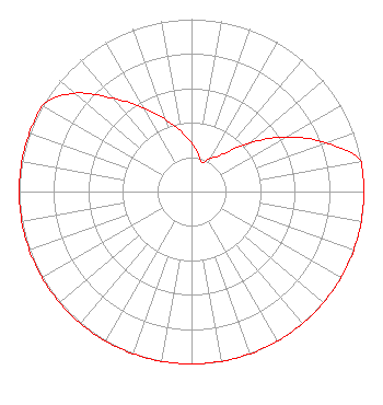 | ||||||||||||||||||
| Azimuth | Ratio | Azimuth | Ratio | Azimuth | Ratio | Azimuth | Ratio | ||||||||||||
| 0 | 0.282 | 10 | 0.224 | 20 | 0.178 | 30 | 0.224 | ||||||||||||
| 40 | 0.282 | 50 | 0.440 | 60 | 0.631 | 70 | 0.830 | ||||||||||||
| 80 | 1.000 | 90 | 1.000 | 100 | 1.000 | 110 | 1.000 | ||||||||||||
| 120 | 1.000 | 130 | 1.000 | 140 | 1.000 | 150 | 1.000 | ||||||||||||
| 160 | 1.000 | 170 | 1.000 | 180 | 1.000 | 190 | 1.000 | ||||||||||||
| 200 | 1.000 | 210 | 1.000 | 220 | 1.000 | 230 | 1.000 | ||||||||||||
| 240 | 1.000 | 250 | 1.000 | 260 | 1.000 | 270 | 1.000 | ||||||||||||
| 280 | 1.000 | 290 | 1.000 | 300 | 1.000 | 310 | 0.887 | ||||||||||||
| 320 | 0.706 | 330 | 0.561 | 340 | 0.446 | 350 | 0.355 | ||||||||||||
Structure Registration Number 1057081 Structure Type: TOWER Registered To: American Towers, LLC Structure Address: 1200 E. Chambers Pike (hindustan#304645) Bloomington, IN County Name: Monroe County ASR Issued: 02/07/2020 Date Built: 06/25/1998 Site Elevation: 264 m (866 ft.) Structure Height: 107.6 m (353 ft.) Height Overall: 109.4 m (359 ft.) Overall Height AMSL: 373.4 m (1225 ft.) FAA Determination: 01/19/2007 FAA Study #: 2006-AGL-9798-OE FAA Circular #: 70/7460-1J Paint & Light FAA Chapters: 4, 8, 13 OM&L to remain the same as prior studies = A MED-DUAL SYSTEM 39-18-36.8 N 86-29-24.0 W (NAD 83) 39-18-36.6 N 86-29-24.0 W (Converted to NAD 27) |
5700 West Oaks Blvd. Rocklin, CA 95765 Phone: 916-251-1600 Not-for-Profit | Title: Ceo Date: 12/16/2022 Application Certifier Educational Media Foundation 5700 West Oaks Blvd. Rocklin, CA 95765 Applicant James L Travis Educational Media Foundation 5700 West Oaks Blvd. Rocklin, CA 95765 FCC COMPLIANCE ENGINEER MARY N O'C0NNOR Wilkinson Barker Knauer Llp 1800 M Street, Nw Suite 800n Washington, DC 20036 | |||||||||||||||||