
FCCInfo.com
A Service of Cavell, Mertz & Associates, Inc.
(855) FCC-INFO
|
|
|
|
|
||||||||||||||||
|
|
W257EH Channel: 257D 99.3 MHz Webster, Massachusetts Service: FX - A translator or application for a translator. Facility ID: 201540 Fac. Service: FX Programming Delivery Method: Unspecified Status: License Application Accepted: 01/11/2023 Application Granted: 01/17/2023 File Number: -0000206679 License Expires: 04/01/2030 Application Type: Minor Modification FCC Website Links: LMS Facility Details This Application Other W257EH Applications Other W257EH Applications in CDBS Including Superseded Applications Mailing Address Correspondence for W257EH Correspondence related to application -0000206679 Service Contour - Open Street Map or USGS Map (60 dBu) Service Contour - KML / Google Earth (60 dBu) Facility Type: FM STATION Class: D, A Noncommercial educational operating with no more than 10W Site Location: 42-02-16.0 N 71-59-18.0 W (NAD 83) Site Location: 42-02-15.7 N 71-59-19.7 W (Converted to NAD 27) Effective Radiated Power: 0.25 kW Antenna Center HAAT: 0 m Antenna Center AMSL: 310 m (1017 ft.) Antenna Center HAG: 75 m (246 ft.) Site Elevation: 235 m. (771 ft.) Height Overall*: 78.6 m (258 ft.) (* As Filed In This Application, may differ from ASR Data, Below.) Directional Antenna Antenna Make/Model: Nicom BKG77-1DA Antenna ID: 1008195 Polarization: H
| ||||||||||||||||||
| Antenna Data for Antenna Id: 1008195 W257EH FX File: -0000206679 Nicom - BKG77-1DA Service: FX | 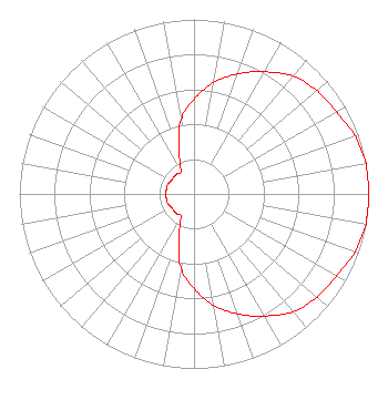 | ||||||||||||||||||
| Azimuth | Ratio | Azimuth | Ratio | Azimuth | Ratio | Azimuth | Ratio | ||||||||||||
| 0 | 0.543 | 10 | 0.646 | 20 | 0.733 | 30 | 0.808 | ||||||||||||
| 40 | 0.882 | 50 | 0.920 | 60 | 0.940 | 70 | 0.980 | ||||||||||||
| 80 | 1.000 | 90 | 1.000 | 100 | 1.000 | 110 | 0.980 | ||||||||||||
| 120 | 0.940 | 130 | 0.920 | 140 | 0.882 | 150 | 0.808 | ||||||||||||
| 160 | 0.733 | 170 | 0.646 | 180 | 0.543 | 190 | 0.430 | ||||||||||||
| 200 | 0.250 | 210 | 0.150 | 220 | 0.150 | 230 | 0.150 | ||||||||||||
| 240 | 0.150 | 250 | 0.160 | 260 | 0.160 | 270 | 0.160 | ||||||||||||
| 280 | 0.160 | 290 | 0.160 | 300 | 0.150 | 310 | 0.150 | ||||||||||||
| 320 | 0.150 | 330 | 0.150 | 340 | 0.250 | 350 | 0.430 | ||||||||||||
Structure Registration Number 1009099 Structure Type: TOWER Structure Address: Blackmere Rd Dudley, MA County Name: Worcester County ASR Issued: 11/07/2002 Date Built: 01/01/1995 Site Elevation: 235 m (771 ft.) Structure Height: 78 m (256 ft.) Height Overall: 78.6 m (258 ft.) Overall Height AMSL: 313.6 m (1029 ft.) FAA Determination: 03/07/1995 FAA Study #: 93-ANE-191-OE FAA Circular #: 70/7460-1H Paint & Light FAA Chapters: 4, 8, 13 42-02-16.0 N 71-59-18.0 W (NAD 83) 42-02-15.7 N 71-59-19.7 W (Converted to NAD 27) |
82 Asnebumskit Rd Paxton, MA 01612 Phone: 508-791-7065 Limited Liability Company | Title: Manager Date: 01/11/2023 Application Certifier Quinebaug Valley Broadcasting, Llc 82 Asnebumskit Rd Paxton, MA 01612 Applicant Charles A. Hecht Charles A. Hecht & Associates, Inc. Charles A. Hecht & Associates, Inc. 19 Mackenzie Court Freehold, NJ 07728 Technical Consultant Dennis Jackson Technical Consultant 19 Boas Ln Wilton, CT 06897 Technical Consultant Allan G. Moskowitz, Esq. Moskowitz Law 10845 Tuckahoe Way North Potomac, MD 20878 Counsel | |||||||||||||||||