
FCCInfo.com
A Service of Cavell, Mertz & Associates, Inc.
(855) FCC-INFO
|
|
|
|
|
||||||||||||||||
|
|
W258CM Channel: 258D 99.5 MHz Madison, Wisconsin Service: FX - A translator or application for a translator. Facility ID: 153013 Fac. Service: FX Programming Delivery Method: Unspecified Status: License Application Accepted: 03/17/2023 Application Granted: 04/04/2023 File Number: -0000212642 License Expires: 12/01/2028 Application Type: License To Cover FCC Website Links: LMS Facility Details This Application Other W258CM Applications Other W258CM Applications in CDBS Including Superseded Applications Mailing Address Correspondence for W258CM Correspondence related to application -0000212642 Service Contour - Open Street Map or USGS Map (60 dBu) Service Contour - KML / Google Earth (60 dBu) Facility Type: FM STATION Class: D, A Noncommercial educational operating with no more than 10W Site Location: 43-10-09.9 N 89-15-38.4 W (NAD 83) Site Location: 43-10-09.9 N 89-15-38.0 W (Converted to NAD 27) Effective Radiated Power: 0.25 kW Transmitter Output Power: 0.13 kW Antenna Center HAAT: 0 m Antenna Center AMSL: 390.5 m (1281 ft.) Antenna Center HAG: 94.5 m (310 ft.) Site Elevation: 296 m. (971 ft.) Height Overall*: 119 m (390 ft.) (* As Filed In This Application, may differ from ASR Data, Below.) Directional Antenna Antenna Make/Model: Nicom BKG77/2DA(0.85WL) Antenna ID: 1009473 Polarization: H
| ||||||||||||||||||
| Antenna Data for Antenna Id: 1009473 W258CM FX File: -0000212642 Nicom - BKG77/2DA(0.85WL) Service: FX | 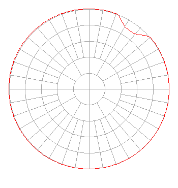 | ||||||||||||||||||
| Azimuth | Ratio | Azimuth | Ratio | Azimuth | Ratio | Azimuth | Ratio | ||||||||||||
| 0 | 1.000 | 10 | 1.000 | 20 | 1.000 | 30 | 0.900 | ||||||||||||
| 40 | 0.900 | 50 | 1.000 | 60 | 1.000 | 70 | 1.000 | ||||||||||||
| 80 | 1.000 | 90 | 1.000 | 100 | 1.000 | 110 | 1.000 | ||||||||||||
| 120 | 1.000 | 130 | 1.000 | 140 | 1.000 | 150 | 1.000 | ||||||||||||
| 160 | 1.000 | 170 | 1.000 | 180 | 1.000 | 190 | 1.000 | ||||||||||||
| 200 | 1.000 | 210 | 1.000 | 220 | 1.000 | 230 | 1.000 | ||||||||||||
| 240 | 1.000 | 250 | 1.000 | 260 | 1.000 | 270 | 1.000 | ||||||||||||
| 280 | 1.000 | 290 | 1.000 | 300 | 1.000 | 310 | 1.000 | ||||||||||||
| 320 | 1.000 | 330 | 1.000 | 340 | 1.000 | 350 | 1.000 | ||||||||||||
Structure Registration Number 1063476 Structure Type: TOWER Registered To: Vertical Bridge CC FM, LLC Structure Address: 3392 Brooks Dr Sun Prairie, WI County Name: Dane County ASR Issued: 12/19/2018 Date Built: 01/01/1984 Site Elevation: 296 m (971 ft.) Structure Height: 117 m (384 ft.) Height Overall: 119 m (390 ft.) Overall Height AMSL: 415 m (1362 ft.) FAA Determination: 10/27/1998 FAA Study #: 98-AGL-4554-OE Paint & Light FAA Chapters: 1, 3, 12, 21 OM&L TO REMAIN PAINT/RED LIGHTS AS PER PRIOR STUDY 84-AGL-763-OE. 43-10-09.9 N 89-15-38.4 W (NAD 83) 43-10-09.9 N 89-15-38.0 W (Converted to NAD 27) |
Pardeeville, WI 53954 Phone: 608-697-7820 Individual | Title: Owner Date: 03/17/2023 Application Certifier DAVID R. MAGNUM N 6837 Bobbi Road Pardeeville, WI 53954 Applicant Justin Asher Asher Broadcast Consulting, Llc 579 Babcock Road Bronson, MI 49028-9347 Technical Consultant John C Trent, Esq. Putbrese, Hunsaker And Trent, Pc 200 South Church Street Woodstock, VA 22664 | |||||||||||||||||