
FCCInfo.com
A Service of Cavell, Mertz & Associates, Inc.
(855) FCC-INFO
|
|
KZAR from 01/14/2005 KZAR from 07/10/2003 KZAR from 09/18/1995 KZAR from 09/18/1987 |
|
|
||||||||||||||||
|
|
KZAR Channel: 292C3 106.3 MHz Mcqueeney, Texas Service: FM - A full-service FM station or application. Facility ID: 25588 Fac. Service: FM Status: Construction Permit 73.215 Station Application Accepted: 07/10/2023 Application Granted: 10/19/2023 File Number: -0000217761 KZAR CP Expires: 10/19/2026 Application Type: Minor Modification FCC Website Links: LMS Facility Details This Application Other KZAR Applications Other KZAR Applications in CDBS Including Superseded Applications Mailing Address Correspondence for KZAR Correspondence related to application -0000217761 Service Contour - Open Street Map or USGS Map (60 dBu) Service Contour - KML / Google Earth (60 dBu) Public Inspection Files Facility Type: NON-COMMERCIAL EDUC. FM Class: C3, A Zone II station; with 6kW-25kW ERP and a class contour distance 28km-39km Site Location: 29-50-08.8 N 98-01-14.3 W (NAD 83) Site Location: 29-50-08.0 N 98-01-13.3 W (Converted to NAD 27) Effective Radiated Power: 14.5 kW Antenna Center HAAT: 131 m (430 ft.) Antenna Center AMSL: 366 m (1201 ft.) Antenna Center HAG: 115 m (377 ft.) Site Elevation: 251.2 m. (824 ft.) Height Overall*: 121 m (397 ft.) (* As Filed In This Application, may differ from ASR Data, Below.) Directional Antenna Antenna Make/Model: None Antenna ID: 1006063 Polarization:
| ||||||||||||||||||
| Antenna Data for Antenna Id: 1006063 KZAR FM File: -0000217761 None - Service: FM | 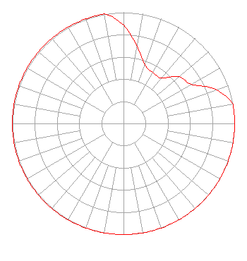 | ||||||||||||||||||
| Azimuth | Ratio | Azimuth | Ratio | Azimuth | Ratio | Azimuth | Ratio | ||||||||||||
| 0 | 0.885 | 10 | 0.704 | 20 | 0.560 | 30 | 0.529 | ||||||||||||
| 40 | 0.532 | 50 | 0.654 | 60 | 0.705 | 70 | 0.886 | ||||||||||||
| 80 | 1.000 | 90 | 1.000 | 100 | 1.000 | 110 | 1.000 | ||||||||||||
| 120 | 1.000 | 130 | 1.000 | 140 | 1.000 | 150 | 1.000 | ||||||||||||
| 160 | 1.000 | 170 | 1.000 | 180 | 1.000 | 190 | 1.000 | ||||||||||||
| 200 | 1.000 | 210 | 1.000 | 220 | 1.000 | 230 | 1.000 | ||||||||||||
| 240 | 1.000 | 250 | 1.000 | 260 | 1.000 | 270 | 1.000 | ||||||||||||
| 280 | 1.000 | 290 | 1.000 | 300 | 1.000 | 310 | 1.000 | ||||||||||||
| 320 | 1.000 | 330 | 1.000 | 340 | 1.000 | 350 | 1.000 | ||||||||||||
Structure Registration Number 1049038 Structure Type: TOWER Registered To: Crown Communications LLC Structure Address: 1107 Quail Run San Marcos, TX County Name: Hays County ASR Issued: 05/06/2016 Date Built: 01/01/1997 Site Elevation: 251.2 m (824 ft.) Structure Height: 119.5 m (392 ft.) Height Overall: 121 m (397 ft.) Overall Height AMSL: 372.2 m (1221 ft.) FAA Determination: 05/23/2012 FAA Study #: 2012-ASW-3352-OE FAA Circular #: 70/7460-1J Paint & Light FAA Chapters: 4, 8, 13 OM&L to remain the same as prior study = A MED-DUAL SYSTEM 29-50-08.8 N 98-01-14.3 W (NAD 83) 29-50-08.0 N 98-01-13.3 W (Converted to NAD 27) |
5700 West Oaks Boulevard Rocklin, CA 95765 Phone: 916-251-1600 Not-for-Profit | Title: Acting Chief Financial Officer Date: 07/10/2023 Application Certifier EDUCATIONAL MEDIA FOUNDATION Educational Media Foundation 5700 West Oaks Boulevard Rocklin, CA 95765 Applicant Donald Lynch Horizon Broadcast Solutions, Llc 111 Sam Houston Drive Kerrville, TX 78028 MARY O'CONNOR Wilkinson Barker Knauer, Llp 1800 M. Street, N.w., Suite 800n Washington, DC 20036 | |||||||||||||||||