
FCCInfo.com
A Service of Cavell, Mertz & Associates, Inc.
(855) FCC-INFO
|
|
|
|
|
||||||||||||||||
|
|
KVWS Channel: 202C3 88.3 MHz Sedalia, Missouri Service: FM - A full-service FM station or application. Facility ID: 766724 Fac. Service: FM Status: Construction Permit Application Accepted: 06/05/2023 Application Granted: 08/11/2023 File Number: -0000216259 KVWS CP Expires: 09/02/2025 Application Type: Minor Modification FCC Website Links: LMS Facility Details This Application Other KVWS Applications Other KVWS Applications in CDBS Including Superseded Applications Mailing Address Correspondence for KVWS Correspondence related to application -0000216259 Service Contour - Open Street Map or USGS Map (60 dBu) Service Contour - KML / Google Earth (60 dBu) Public Inspection Files Facility Type: NON-COMMERCIAL EDUC. FM Class: C3, A Zone II station; with 6kW-25kW ERP and a class contour distance 28km-39km Site Location: 38-35-37.0 N 93-31-27.0 W (NAD 83) Site Location: 38-35-36.9 N 93-31-26.2 W (Converted to NAD 27) Effective Radiated Power: 12 kW Antenna Center HAAT: 131 m (430 ft.) Antenna Center AMSL: 399 m (1309 ft.) Antenna Center HAG: 113 m (371 ft.) Site Elevation: 285.9 m. (938 ft.) Height Overall*: 150.9 m (495 ft.) (* As Filed In This Application, may differ from ASR Data, Below.) Directional Antenna Antenna Make/Model: None Antenna ID: 1006063 Polarization: | ||||||||||||||||||
| Antenna Data for Antenna Id: 1006063 KVWS FM File: -0000216259 None - Service: FM | 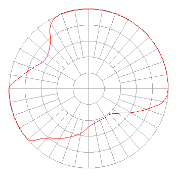 | ||||||||||||||||||
| Azimuth | Ratio | Azimuth | Ratio | Azimuth | Ratio | Azimuth | Ratio | ||||||||||||
| 0 | 1.000 | 10 | 1.000 | 20 | 1.000 | 30 | 1.000 | ||||||||||||
| 40 | 1.000 | 50 | 1.000 | 60 | 1.000 | 70 | 1.000 | ||||||||||||
| 80 | 1.000 | 90 | 1.000 | 100 | 0.953 | 110 | 0.767 | ||||||||||||
| 120 | 0.610 | 130 | 0.485 | 140 | 0.423 | 150 | 0.423 | ||||||||||||
| 160 | 0.423 | 170 | 0.445 | 180 | 0.485 | 190 | 0.577 | ||||||||||||
| 200 | 0.646 | 210 | 0.726 | 220 | 0.814 | 230 | 1.000 | ||||||||||||
| 240 | 1.000 | 250 | 1.000 | 260 | 1.000 | 270 | 1.000 | ||||||||||||
| 280 | 0.863 | 290 | 0.747 | 300 | 0.665 | 310 | 0.665 | ||||||||||||
| 320 | 0.747 | 330 | 0.939 | 340 | 1.000 | 350 | 1.000 | ||||||||||||
Structure Registration Number 1225874 Structure Type: TOWER Registered To: D&H Media, LLC Structure Address: Ww And 1050 Road Windsor, MO County Name: Johnson County ASR Issued: 05/23/2001 Date Built: 02/26/2002 Site Elevation: 285.9 m (938 ft.) Structure Height: 150.9 m (495 ft.) Height Overall: 150.9 m (495 ft.) Overall Height AMSL: 436.8 m (1433 ft.) FAA Determination: 11/06/2000 FAA Study #: 00-ACE-1954-OE FAA Circular #: 70/7460-1K Paint & Light FAA Chapters: 3, 4, 5, 12 SUPPLEMENTAL NOTICE STATES STRUCTURE REACHED GREATEST HEIGHT ON 02/16/2002 38-35-37.0 N 93-31-27.0 W (NAD 83) 38-35-36.9 N 93-31-26.2 W (Converted to NAD 27) |
10550 Barkley Suite 100 Overland Park, KS 66212 Phone: 913-642-7770 Not-for-Profit | Title: Vice President Date: 06/05/2023 Application Certifier Community Broadcasting, Inc. 10550 Barkley Suite 100 Overland Park, KS 66212 Applicant Justin Asher Asher Broadcast Consulting, Llc 579 Babcock Road Bronson, MI 49028 Technical Consultant KATHLEEN VICTORY Fletcher Heald & Hildreth, Plc 1300 N. 17th Street Suite 1100 Arlington, VA 22209 FCC COUNSEL | |||||||||||||||||