
FCCInfo.com
A Service of Cavell, Mertz & Associates, Inc.
(855) FCC-INFO
|
|
|
|
|
||||||||||||||||
|
|
W235AW Channel: 235D 94.9 MHz Monticello, New York Service: FX - A translator or application for a translator. Facility ID: 152894 Fac. Service: FX Programming Delivery Method: Unspecified Status: License Application Accepted: 06/20/2023 Application Granted: 06/30/2023 File Number: -0000216882 License Expires: 06/01/2030 Application Type: License To Cover FCC Website Links: LMS Facility Details This Application Other W235AW Applications Other W235AW Applications in CDBS Including Superseded Applications Mailing Address Correspondence for W235AW Correspondence related to application -0000216882 Service Contour - Open Street Map or USGS Map (60 dBu) Service Contour - KML / Google Earth (60 dBu) Facility Type: FM STATION Class: D, A Noncommercial educational operating with no more than 10W Site Location: 41-39-39.0 N 74-41-11.0 W (NAD 83) Site Location: 41-39-38.7 N 74-41-12.4 W (Converted to NAD 27) Effective Radiated Power: 0.25 kW Transmitter Output Power: 0.006 kW Antenna Center HAAT: 98.8 m Horiz.; 0 m Vert. Antenna Center AMSL: 544 m (1785 ft.) Antenna Center HAG: 58 m (190 ft.) Site Elevation: 486 m. (1594 ft.) Height Overall*: 60.9 m (200 ft.) (* As Filed In This Application, may differ from ASR Data, Below.) Directional Antenna Antenna Make/Model: Kathrein Scala CA2-Slant45-Special Antenna ID: 16153 Polarization: H
| ||||||||||||||||||
| Antenna Data for Antenna Id: 16153 W235AW FX File: -0000216882 Kathrein Scala - CA2-Slant45-Special Service: FX | 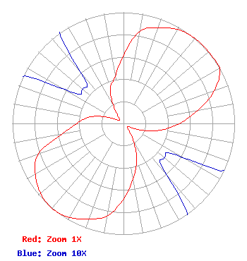 | ||||||||||||||||||
| Azimuth | Ratio | Azimuth | Ratio | Azimuth | Ratio | Azimuth | Ratio | ||||||||||||
| 0 | 0.611 | 10 | 0.843 | 20 | 0.916 | 30 | 0.976 | ||||||||||||
| 40 | 1.000 | 50 | 1.000 | 60 | 1.000 | 70 | 0.869 | ||||||||||||
| 80 | 0.680 | 90 | 0.504 | 100 | 0.345 | 110 | 0.177 | ||||||||||||
| 120 | 0.061 | 130 | 0.048 | 140 | 0.061 | 150 | 0.177 | ||||||||||||
| 160 | 0.345 | 170 | 0.504 | 180 | 0.680 | 190 | 0.845 | ||||||||||||
| 200 | 0.916 | 210 | 0.976 | 220 | 1.000 | 230 | 0.976 | ||||||||||||
| 240 | 0.916 | 250 | 0.819 | 260 | 0.567 | 270 | 0.419 | ||||||||||||
| 280 | 0.317 | 290 | 0.177 | 300 | 0.061 | 310 | 0.048 | ||||||||||||
| 320 | 0.061 | 330 | 0.177 | 340 | 0.345 | 350 | 0.429 | ||||||||||||
Structure Registration Number 1264053 Structure Type: TOWER Registered To: SONOCOP Holdings, LLC Structure Address: Hillcrest Ave. Monticello, NY County Name: Sullivan County ASR Issued: 06/14/2021 Date Built: 04/30/2009 Site Elevation: 486 m (1594 ft.) Structure Height: 56.4 m (185 ft.) Height Overall: 60.9 m (200 ft.) Overall Height AMSL: 546.9 m (1794 ft.) FAA Determination: 06/25/2008 FAA Study #: 2008-AEA-2636-OE Paint & Light FAA Chapters: NONE 41-39-39.0 N 74-41-11.0 W (NAD 83) 41-39-38.7 N 74-41-12.4 W (Converted to NAD 27) |
575 Grove Street Honesdale, PA 18431 Phone: 570-253-1616 Limited Partnership | Title: Member Date: 06/20/2023 Application Certifier BOLD GOLD MEDIA GROUP, L.P. Bold Gold Media Group, L.p. 575 Grove Street Honesdale, PA 18431 Applicant Mark Denbo, Esq. Smithwick & Belendiuk, P.c. 5028 Wisconsin Ave., Nw Suite 301 Washington, DC 20016 Bud Williamson Digital Radio Engineering, Inc. 135 White Bridge Rd Middletown, NY 10940 Technical Consultant | |||||||||||||||||