
FCCInfo.com
A Service of Cavell, Mertz & Associates, Inc.
(855) FCC-INFO
|
|
KYFG from 02/01/1999 KYFG from 11/01/1996 KYFG from 04/26/1996 |
|  |
|
|||||||||||||||
|
|
KYFG Channel: 205A 88.9 MHz Omaha, Nebraska Service: FM - A full-service FM station or application. Facility ID: 50311 Fac. Service: FM Status: License Application Accepted: 07/25/2023 Application Granted: 09/14/2023 File Number: -0000218487 License Expires: 06/01/2029 Application Type: Minor Modification FCC Website Links: LMS Facility Details This Application Other KYFG Applications Other KYFG Applications in CDBS Including Superseded Applications Mailing Address Correspondence for KYFG Correspondence related to application -0000218487 Service Contour - Open Street Map or USGS Map (60 dBu) Service Contour - KML / Google Earth (60 dBu) Public Inspection Files Facility Type: NON-COMMERCIAL EDUC. FM Class: A, A Zone I; I-A; or II station; with 0.1kW-6kW ERP and a class contour distance <=28km Site Location: 41-18-47.0 N 96-00-37.0 W (NAD 83) Site Location: 41-18-47.0 N 96-00-35.9 W (Converted to NAD 27) Effective Radiated Power: 0.085 kW Horiz. ; 1.5 kW Vert. Transmitter Output Power: 0.385 kW Antenna Center HAAT: 147 m (482 ft.) Antenna Center AMSL: 485 m (1591 ft.) Antenna Center HAG: 134 m (440 ft.) Site Elevation: 351 m. (1152 ft.) Height Overall*: 154 m (505 ft.) (* As Filed In This Application, may differ from ASR Data, Below.) Directional Antenna Antenna Make/Model: Shively Labs 6810-3R-H/V-DA, 3 bays Antenna ID: 44366 Polarization: H
| ||||||||||||||||||
| Antenna Data for Antenna Id: 44366 KYFG FM File: -0000218487 Shively Labs - 6810-3R-H/V-DA, 3 bays Service: FM | 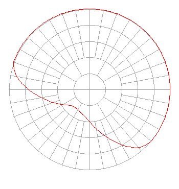 | ||||||||||||||||||
| Azimuth | Ratio | Azimuth | Ratio | Azimuth | Ratio | Azimuth | Ratio | ||||||||||||
| 0 | 1.000 | 10 | 1.000 | 20 | 1.000 | 30 | 1.000 | ||||||||||||
| 40 | 1.000 | 50 | 1.000 | 60 | 1.000 | 70 | 1.000 | ||||||||||||
| 80 | 1.000 | 90 | 1.000 | 100 | 1.000 | 110 | 1.000 | ||||||||||||
| 120 | 1.000 | 130 | 1.000 | 140 | 0.943 | 150 | 0.793 | ||||||||||||
| 160 | 0.630 | 170 | 0.501 | 180 | 0.400 | 190 | 0.340 | ||||||||||||
| 200 | 0.310 | 210 | 0.289 | 220 | 0.289 | 230 | 0.310 | ||||||||||||
| 240 | 0.380 | 250 | 0.479 | 260 | 0.602 | 270 | 0.758 | ||||||||||||
| 280 | 0.916 | 290 | 1.000 | 300 | 1.000 | 310 | 1.000 | ||||||||||||
| 320 | 1.000 | 330 | 1.000 | 340 | 1.000 | 350 | 1.000 | ||||||||||||
Structure Registration Number 1025457 Structure Type: TOWER Registered To: Hickory Radio, LLC Structure Address: 64th & Hartman Sts Omaha, NE County Name: Douglas County ASR Issued: 11/30/2018 Date Built: 01/01/1968 Site Elevation: 350.9 m (1151 ft.) Structure Height: 153.6 m (504 ft.) Height Overall: 153.9 m (505 ft.) Overall Height AMSL: 504.8 m (1656 ft.) FAA Determination: 01/14/1998 FAA Study #: 97-ACE-1773-OE FAA Circular #: 70/7460-1J Paint & Light FAA Chapters: 3, 4, 5, 13 41-18-47.0 N 96-00-37.0 W (NAD 83) 41-18-47.0 N 96-00-35.9 W (Converted to NAD 27) |
11530 Carmel Commons Blvd Charlotte, NC 28226 Phone: 704-523-5555 Limited Liability Company | Title: Secretary-treasurer Date: 07/25/2023 Application Certifier BIBLE BROADCASTING NETWORK, INC. Bible Broadcasting Network, Inc. 11530 Carmel Commons Blvd Charlotte, NC 28226 Applicant Justin Asher Asher Broadcast Consulting, Llc 579 Babcock Road Bronson, MI 49028-9347 Technical Consultant Gary S. Smithwick, Esq Smithwick & Belendiuk, P.c. 5028 Wisconsin Avenue, N.w. Suite 301 Washington, DC 20016 Legal Counsel | |||||||||||||||||