
FCCInfo.com
A Service of Cavell, Mertz & Associates, Inc.
(855) FCC-INFO
|
|
WKIF from 12/01/2014 WKIF from 03/12/2012 |
|
|
||||||||||||||||
|
|
WAIH Channel: 243A 96.5 MHz Holly Springs, Mississippi Service: FM - A full-service FM station or application. Facility ID: 171031 Fac. Service: FM Status: License (Licensed And Reduced Power) 73.215 Station Application Accepted: 07/27/2023 Application Granted: 07/28/2023 File Number: -0000218544 License Expires: 06/01/2028 Application Type: Channel Substitution/Community of License Change Call Sign Request FCC Website Links: LMS Facility Details This Application Other WAIH Applications Other WAIH Applications in CDBS Including Superseded Applications Mailing Address Correspondence for WAIH Correspondence related to application -0000218544 Service Contour - Open Street Map or USGS Map (60 dBu) Service Contour - KML / Google Earth (60 dBu) Public Inspection Files Facility Type: NON-COMMERCIAL EDUC. FM Class: A, A Zone I; I-A; or II station; with 0.1kW-6kW ERP and a class contour distance <=28km Site Location: 34-41-32.4 N 89-32-10.3 W (NAD 83) Site Location: 34-41-32.0 N 89-32-10.0 W (Converted to NAD 27) Effective Radiated Power: 4.1 kW Transmitter Output Power: 1.8 kW Antenna Center HAAT: 122 m (400 ft.) Antenna Center AMSL: 259 m (850 ft.) Antenna Center HAG: 113 m (371 ft.) Calculated Site Elevation: 146 m. (479 ft.) Height Overall*: 117 m (384 ft.) (* As Filed In This Application, may differ from ASR Data, Below.) Directional Antenna Antenna Make/Model: Shivley 6810 Antenna ID: 109139 Polarization: | ||||||||||||||||||
| Antenna Data for Antenna Id: 109139 WAIH FM File: -0000218544 Shivley - 6810 Service: FM | 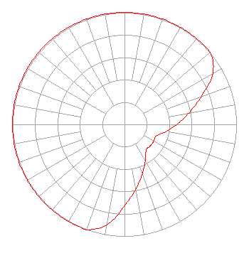 | ||||||||||||||||||
| Azimuth | Ratio | Azimuth | Ratio | Azimuth | Ratio | Azimuth | Ratio | ||||||||||||
| 0 | 1.000 | 10 | 1.000 | 20 | 1.000 | 30 | 1.000 | ||||||||||||
| 40 | 1.000 | 50 | 1.000 | 60 | 0.910 | 70 | 0.730 | ||||||||||||
| 80 | 0.585 | 90 | 0.468 | 100 | 0.375 | 110 | 0.300 | ||||||||||||
| 120 | 0.300 | 130 | 0.300 | 140 | 0.300 | 150 | 0.375 | ||||||||||||
| 160 | 0.468 | 170 | 0.585 | 180 | 0.730 | 190 | 0.910 | ||||||||||||
| 200 | 1.000 | 210 | 1.000 | 220 | 1.000 | 230 | 1.000 | ||||||||||||
| 240 | 1.000 | 250 | 1.000 | 260 | 1.000 | 270 | 1.000 | ||||||||||||
| 280 | 1.000 | 290 | 1.000 | 300 | 1.000 | 310 | 1.000 | ||||||||||||
| 320 | 1.000 | 330 | 1.000 | 340 | 1.000 | 350 | 1.000 | ||||||||||||
Structure Registration Number 1283144 Structure Type: TOWER Registered To: Educational Media Foundation Structure Address: Yarbrough Church Road Holly Springs, MS County Name: Marshall County ASR Issued: 11/18/2020 Date Built: 11/19/2012 Site Elevation: 146.3 m (480 ft.) Structure Height: 115.8 m (380 ft.) Height Overall: 116.7 m (383 ft.) Overall Height AMSL: 263 m (863 ft.) FAA Determination: 02/27/2012 FAA Study #: 2012-aso-536-oe FAA Circular #: 70/7460-1K Paint & Light FAA Chapters: 3, 4, 5, 12 Removed expiration date from determination. Scenario 1./jjs/case#635066 34-41-32.4 N 89-32-10.6 W (NAD 83) 34-41-32.0 N 89-32-10.3 W (Converted to NAD 27) |
5700 West Oaks Blvd. Rocklin, CA 95765 Phone: 916-251-1600 Private Not-for-Profit Educational Institution | Title: Acting Chief Financial Officer Date: 07/27/2023 Application Certifier GEORGE S. FLINN, JR. Educational Media Foundation 5700 West Oaks Blvd. Rocklin, CA 95765 Applicant Mary N O'Connor Wilkinson Barker Knauer, Llp 1800 M Street, Nw Suite 800n Washington, DC 20036 | |||||||||||||||||