
FCCInfo.com
A Service of Cavell, Mertz & Associates, Inc.
(855) FCC-INFO
|
|
K205CU from 12/23/1996 |
|
|
||||||||||||||||
|
|
K259DL Channel: 259D 99.7 MHz Burwell, Nebraska Service: FX - A translator or application for a translator. Facility ID: 82283 Fac. Service: FX Programming Delivery Method: Unspecified Status: License Application Accepted: 08/31/2023 Application Granted: 09/08/2023 File Number: -0000220321 License Expires: 06/01/2029 Application Type: License To Cover FCC Website Links: LMS Facility Details This Application Other K259DL Applications Other K259DL Applications in CDBS Including Superseded Applications Mailing Address Correspondence for K259DL Correspondence related to application -0000220321 Service Contour - Open Street Map or USGS Map (60 dBu) Service Contour - KML / Google Earth (60 dBu) Facility Type: NON-COMMERCIAL EDUC. FM Class: D, A Noncommercial educational operating with no more than 10W Site Location: 41-54-06.9 N 99-06-12.4 W (NAD 83) Site Location: 41-54-06.9 N 99-06-11.0 W (Converted to NAD 27) Effective Radiated Power: 0.25 kW Antenna Center HAAT: 0 m Horiz.; 37 m Vert. Antenna Center AMSL: 952.2 m (3124 ft.) Antenna Center HAG: 198.1 m (650 ft.) Site Elevation: 754.1 m. (2474 ft.) Height Overall*: 259.1 m (850 ft.) (* As Filed In This Application, may differ from ASR Data, Below.) Directional Antenna Antenna Make/Model: Nicom BKY3P Antenna ID: 1008260 Polarization: H
| ||||||||||||||||||
| Antenna Data for Antenna Id: 1008260 K259DL FX File: -0000220321 Nicom - BKY3P Service: FX | 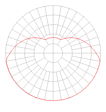 | ||||||||||||||||||
| Azimuth | Ratio | Azimuth | Ratio | Azimuth | Ratio | Azimuth | Ratio | ||||||||||||
| 0 | 0.325 | 10 | 0.325 | 20 | 0.325 | 30 | 0.325 | ||||||||||||
| 40 | 0.400 | 50 | 0.500 | 60 | 0.600 | 70 | 0.700 | ||||||||||||
| 80 | 0.800 | 90 | 0.900 | 100 | 1.000 | 110 | 1.000 | ||||||||||||
| 120 | 1.000 | 130 | 1.000 | 140 | 1.000 | 150 | 1.000 | ||||||||||||
| 160 | 1.000 | 170 | 1.000 | 180 | 1.000 | 190 | 1.000 | ||||||||||||
| 200 | 1.000 | 210 | 1.000 | 220 | 1.000 | 230 | 1.000 | ||||||||||||
| 240 | 1.000 | 250 | 1.000 | 260 | 1.000 | 270 | 0.900 | ||||||||||||
| 280 | 0.800 | 290 | 0.700 | 300 | 0.600 | 310 | 0.500 | ||||||||||||
| 320 | 0.400 | 330 | 0.325 | 340 | 0.325 | 350 | 0.325 | ||||||||||||
Structure Registration Number 1299728 Structure Type: GTOWER Registered To: MJ Leasing LLC Structure Address: Off 833 Road Burwell, NE County Name: Garfield County ASR Issued: 07/07/2016 Date Built: 07/14/2017 Site Elevation: 754.1 m (2474 ft.) Structure Height: 259.1 m (850 ft.) Height Overall: 259.1 m (850 ft.) Overall Height AMSL: 1013.2 m (3324 ft.) FAA Determination: 12/15/2015 FAA Study #: 2015-ACE-3166-OE FAA Circular #: 70/7460-1L Paint & Light FAA Chapters: 3, 4, 5, 12 Removed expiration date from determination. Scenario 1./jjs/case#635066 41-54-06.9 N 99-06-12.4 W (NAD 83) 41-54-06.9 N 99-06-11.0 W (Converted to NAD 27) |
P.o. Box 880 Lexington, NE 68850 Phone: 308-324-2371 Not-for-Profit | Title: President Date: 08/31/2023 Application Certifier THE PRAISE NETWORK, INC. The Praise Network, Inc. 128 South 4th Street O'neil, NE 68763 Applicant DONALD MARTIN Law Office Of Donald E. Martin P.o. Box 8433 Falls Church, VA 22041 Attorney Justin Asher Asher Broadcast Consulting, Llc 579 Babcock Road Bronson, MI 49028 Technical Consultant JOHN WELLS KING, ESQ Law Office Of John Wells King, Pllc 4051 Shoal Creek Lane East Jacksonville, FL 32225 COUNSEL | |||||||||||||||||